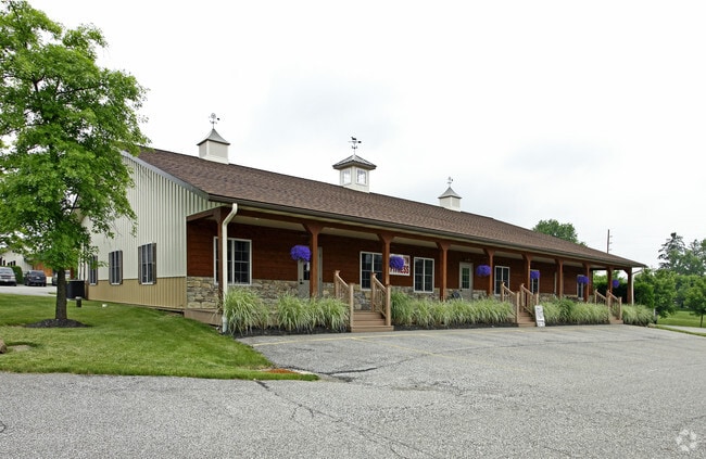
Property Record
9967 Washington St, Chagrin Falls, OH 44023
Property Detail
9967 Washington St
01-119092
BLDG 9 UNIT E1 RADVAN BUSINESS PARK CONDOMINIUMS #4
Officecondo
Geauga
B1
Ohio
B and X Area of moderate flood hazard, usually the area between the limits of the 100-year and 500-year floods.
0.17 AC
2025
Geauga County
2025
Cleveland
311900
Cleveland-Elyria, OH
1,620 SF
NEARBY LISTINGS FOR SALE OR LEASE
DEMOGRAPHICS near 9967 Washington St
1 mile
3 mile
5 mile
2025 Total Population
1,439
9,655
26,300
2030 Population
1,433
9,582
26,245
Pop Growth 2025-2030
(0.42%)
(0.76%)
(0.21%)
Average Age
48
46
45
2025 Total Households
574
3,675
9,691
HH Growth 2025-2030
(0.35%)
(0.82%)
(0.25%)
Median Household Inc
$127,734
$124,104
$127,656
Avg Household Size
2.50
2.60
2.60
2025 Avg HH Vehicles
2.00
2.00
2.00
Median Home Value
$416,223
$400,120
$418,789
Median Year Built
1991
1978
1981
Nearby Places
Map Layers
Map Styles
 Street
 Aerial
Layers
 Traffic
 Biking
Places
Listings with unknown addresses are not visible on the map
- Restaurants
- Banks
- Shops
- Fitness
- Groceries
PUBLIC TRANSPORTATION
AIRPORT
Cleveland-Hopkins International
Drive
Walk
Distance
Cleveland-Hopkins International
48 min
33.1 mi
SALE & LEASE HISTORY
LISTING DATE
SALE/LEASE

Sep 25, 2016
For Lease
Jul 16, 2021
For Sale
Feb 03, 2021
For Sale
Nearby Properties
Address
Land Use
TOTAL SIZE
Lot Size
Zoning
Address
Land Use
TOTAL SIZE
Lot Size
Zoning
227,389 SF
27.75 AC
R5A
Address
Land Use
TOTAL SIZE
Lot Size
Zoning
79,668 SF
14 AC
R5A
Address
Land Use
TOTAL SIZE
Lot Size
Zoning
18,614 SF
45.79 AC
R3A
Address
Land Use
TOTAL SIZE
Lot Size
Zoning
100,601 SF
40.70 AC
R5A
Address
Land Use
TOTAL SIZE
Lot Size
Zoning
120,010 SF
11.92 AC
CB
Address
Land Use
TOTAL SIZE
Lot Size
Zoning
3,124 SF
60.91 AC
R3A
Address
Land Use
TOTAL SIZE
Lot Size
Zoning
30,295 SF
7.12 AC
R5A
Address
Land Use
TOTAL SIZE
Lot Size
Zoning
20,820 SF
7.19 AC
B1
Address
Land Use
TOTAL SIZE
Lot Size
Zoning
35,911 SF
6.50 AC
CB
Address
Land Use
TOTAL SIZE
Lot Size
Zoning
4,814 SF
63.75 AC
R1
Address
Land Use
TOTAL SIZE
Lot Size
Zoning
37,625 SF
5.43 AC
CB
Address
Land Use
TOTAL SIZE
Lot Size
Zoning
71,570 SF
11.04 AC
I1
Address
Land Use
TOTAL SIZE
Lot Size
Zoning
62,290 SF
7.38 AC
I1
Address
Land Use
TOTAL SIZE
Lot Size
Zoning
81,899 SF
2.23 AC
I1
Address
Land Use
TOTAL SIZE
Lot Size
Zoning
1,897 SF
44.70 AC
R5A
Address
Land Use
TOTAL SIZE
Lot Size
Zoning
1,886 SF
4.85 AC
R3A
Address
Land Use
TOTAL SIZE
Lot Size
Zoning
17,910 SF
2.01 AC
CB
Address
Land Use
TOTAL SIZE
Lot Size
Zoning
20,235 SF
0.84 AC
CB
Address
Land Use
TOTAL SIZE
Lot Size
Zoning
15,328 SF
54.91 AC
R1
Address
Land Use
TOTAL SIZE
Lot Size
Zoning
4,887 SF
74.27 AC
R5A
Address
Land Use
TOTAL SIZE
Lot Size
Zoning
34,988 SF
12.36 AC
R5A
Address
Land Use
TOTAL SIZE
Lot Size
Zoning
58,489 SF
3.92 AC
CB
Address
Land Use
TOTAL SIZE
Lot Size
Zoning
57,340 SF
17 AC
R5A
Address
Land Use
TOTAL SIZE
Lot Size
Zoning
2,472 SF
74.27 AC
R1
Address
Land Use
TOTAL SIZE
Lot Size
Zoning
7,173 SF
21.58 AC
R1
Address
Land Use
TOTAL SIZE
Lot Size
Zoning
75.78 AC
R5A
Address
Land Use
TOTAL SIZE
Lot Size
Zoning
250 AC
OS1
Address
Land Use
TOTAL SIZE
Lot Size
Zoning
19,703 SF
12.24 AC
R3A
Address
Land Use
TOTAL SIZE
Lot Size
Zoning
3,152 SF
129.38 AC
R5A
Address
Land Use
TOTAL SIZE
Lot Size
Zoning
62,353 SF
21.10 AC
I1
The World's #1 Commercial Real Estate Marketplace
Connect with us
© 2026 CoStar Group
The information above has been obtained from sources believed reliable. While we do not doubt its accuracy we have not verified it and make no guarantee, warranty or representation about it. It is your responsibility to independently confirm its accuracy and completeness. Any projections, opinions, assumptions, or estimates used are for example only and do not represent the current or future performance of the property. The value of this transaction to you depends on tax and other factors which should be evaluated by your tax, financial, and legal advisors. You and your advisors should conduct a careful, independent investigation of the property to determine to your satisfaction the suitability of the property for your needs.