Property Record
929 2Nd Ave E, Oneonta, AL 35121
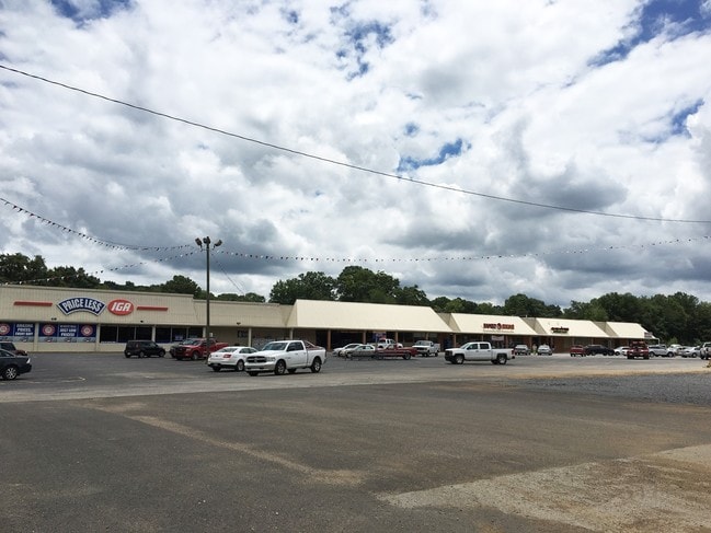

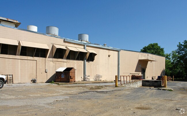
Property Detail
929 2Nd Ave E
16-09-30-4-003-023.000
COM SE COR SE/4 N 35 ALG E SEC LN POB N 550 ALG E LN NWLY 135 TO BR SWLY 196 ALG BR NW 158 TO R/W SW ALG R/W 560 SE 157 SW TO
Stripcommercialcenter
BLOUNT
AE The base floodplain where base flood elevations are provided. AE Zones are now used on new format FIRMs instead of A1-A30 Zones.
Alabama
2025
6.90 AC
2024
Blount County
050105
Birmingham
49,700 SF
Birmingham, AL
NEARBY LISTINGS FOR SALE OR LEASE
DEMOGRAPHICS near 929 2Nd Ave E
1 mile
3 mile
5 mile
2025 Total Population
3,065
7,769
11,864
2030 Population
3,119
7,909
12,110
Pop Growth 2025-2030
+ 1.76%
+ 1.80%
+ 2.07%
Average Age
42
41
41
2025 Total Households
1,155
2,924
4,461
HH Growth 2025-2030
+ 1.73%
+ 1.81%
+ 2.08%
Median Household Inc
$57,468
$54,111
$54,369
Avg Household Size
2.50
2.50
2.50
2025 Avg HH Vehicles
2.00
2.00
2.00
Median Home Value
$237,081
$206,282
$197,844
Median Year Built
1968
1971
1976
Nearby Places
Map Layers
Map Styles
 Street
 Aerial
Transit
 Traffic
 Biking
Places
Listings with unknown addresses are not visible on the map
- Restaurants
- Banks
- Shops
- Fitness
- Groceries
PUBLIC TRANSPORTATION
AIRPORT
Birmingham-Shuttlesworth International
Drive
Walk
Distance
Birmingham-Shuttlesworth International
56 min
35.5 mi
Freight Ports
Port of Mobile
Drive
Walk
Distance
Port of Mobile
337 min
294.4 mi
SALE & LEASE HISTORY
LISTING DATE
SALE/LEASE

Sep 25, 2016
For Lease
Sep 24, 2016
For Sale
Mar 31, 2017
For Lease
Nearby Properties
Address
Land Use
TOTAL SIZE
Lot Size
Zoning
Address
Land Use
TOTAL SIZE
Lot Size
Zoning
147,374 SF
11 AC
Address
Land Use
TOTAL SIZE
Lot Size
Zoning
45,720 SF
5.60 AC
Address
Land Use
TOTAL SIZE
Lot Size
Zoning
42,799 SF
6.10 AC
Address
Land Use
TOTAL SIZE
Lot Size
Zoning
27,944 SF
1.08 AC
Address
Land Use
TOTAL SIZE
Lot Size
Zoning
22,168 SF
2.90 AC
Address
Land Use
TOTAL SIZE
Lot Size
Zoning
32,392 SF
1.34 AC
Address
Land Use
TOTAL SIZE
Lot Size
Zoning
24,872 SF
24 AC
Address
Land Use
TOTAL SIZE
Lot Size
Zoning
23,245 SF
0.99 AC
Address
Land Use
TOTAL SIZE
Lot Size
Zoning
15,626 SF
0.36 AC
Address
Land Use
TOTAL SIZE
Lot Size
Zoning
99,004 SF
18 AC
Address
Land Use
TOTAL SIZE
Lot Size
Zoning
6,418 SF
8.10 AC
Address
Land Use
TOTAL SIZE
Lot Size
Zoning
45,000 SF
7.20 AC
Address
Land Use
TOTAL SIZE
Lot Size
Zoning
18,592 SF
0.50 AC
Address
Land Use
TOTAL SIZE
Lot Size
Zoning
63,040 SF
6 AC
Address
Land Use
TOTAL SIZE
Lot Size
Zoning
8,970 SF
0.65 AC
Address
Land Use
TOTAL SIZE
Lot Size
Zoning
11,921 SF
6.70 AC
Address
Land Use
TOTAL SIZE
Lot Size
Zoning
10,000 SF
1.02 AC
Address
Land Use
TOTAL SIZE
Lot Size
Zoning
9,238 SF
1.71 AC
Address
Land Use
TOTAL SIZE
Lot Size
Zoning
15,928 SF
0.96 AC
Address
Land Use
TOTAL SIZE
Lot Size
Zoning
20,930 SF
2.30 AC
Address
Land Use
TOTAL SIZE
Lot Size
Zoning
38,561 SF
3 AC
Address
Land Use
TOTAL SIZE
Lot Size
Zoning
14,560 SF
4 AC
Address
Land Use
TOTAL SIZE
Lot Size
Zoning
10,004 SF
1.09 AC
Address
Land Use
TOTAL SIZE
Lot Size
Zoning
19,602 SF
4.70 AC
Address
Land Use
TOTAL SIZE
Lot Size
Zoning
14,800 SF
2.98 AC
Address
Land Use
TOTAL SIZE
Lot Size
Zoning
15,855 SF
1.22 AC
Address
Land Use
TOTAL SIZE
Lot Size
Zoning
The World's #1 Commercial Real Estate Marketplace
Connect with us
© 2026 CoStar Group
The information above has been obtained from sources believed reliable. While we do not doubt its accuracy we have not verified it and make no guarantee, warranty or representation about it. It is your responsibility to independently confirm its accuracy and completeness. Any projections, opinions, assumptions, or estimates used are for example only and do not represent the current or future performance of the property. The value of this transaction to you depends on tax and other factors which should be evaluated by your tax, financial, and legal advisors. You and your advisors should conduct a careful, independent investigation of the property to determine to your satisfaction the suitability of the property for your needs.