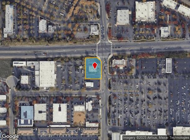
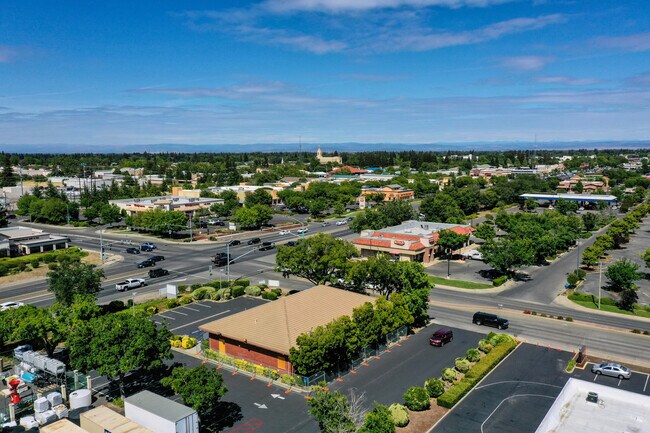
Property Record
998 Tharp Rd, Yuba City, CA 95993
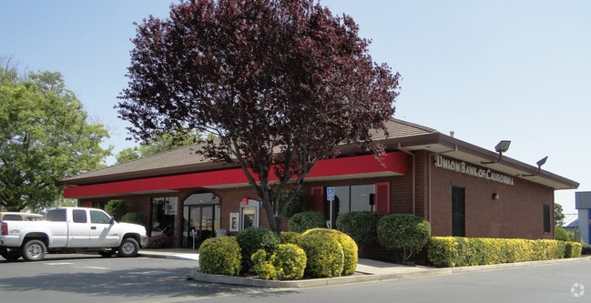

This Property Is For Sale
Current Lease Availabilities
NEARBY LISTINGS FOR SALE OR LEASE
Property Detail
998 Tharp Rd
Sacramento
Parcel Map 862
Yuba City, CA
FORMERLY @: 04-430-037 - ADDED 10-08-2002 PARCEL 1 PARCEL MAP 862
58-050-037
Sutter
Commercialnec
California
2024
2
2025
0.73 AC
050501
Outer Sutter County
4,002 SF
DEMOGRAPHICS near 998 Tharp Rd
1 Mile
3 Mile
5 Mile
2024 Total Population
9,452
71,514
102,364
2029 Population
9,353
70,917
103,760
Pop Growth 2024-2029
(1.05%)
(0.83%)
+ 1.36%
Average Age
39
39
39
2024 Total Households
3,202
24,271
34,378
HH Growth 2024-2029
(1.03%)
(0.78%)
+ 1.56%
Median Household Inc
$55,359
$61,356
$59,854
Avg Household Size
2.90
2.90
2.90
2024 Avg HH Vehicles
2.00
2.00
2.00
Median Home Value
$363,908
$355,189
$344,990
Median Year Built
1986
1979
1979
Nearby Places
Map Layers
Map Styles
 Street
 Aerial
- Restaurants
- Banks
- Shops
- Fitness
- Groceries
PUBLIC TRANSPORTATION
AIRPORT
Sacramento International
DRIVE
WALK
Distance
Sacramento International
51 min
39.1 mi
Nearby Properties
Address
Land Use
TOTAL SIZE
Lot Size
Zoning
Address
Land Use
TOTAL SIZE
Lot Size
Zoning
30,734 SF
1.38 AC
C-3
Address
Land Use
TOTAL SIZE
Lot Size
Zoning
25,580 SF
9.48 AC
C3
Address
Land Use
TOTAL SIZE
Lot Size
Zoning
98,830 SF
0.40 AC
C-3
Address
Land Use
TOTAL SIZE
Lot Size
Zoning
1,028,560 SF
52.30 AC
M1
Address
Land Use
TOTAL SIZE
Lot Size
Zoning
48,348 SF
3.25 AC
Address
Land Use
TOTAL SIZE
Lot Size
Zoning
143,368 SF
11.40 AC
Address
Land Use
TOTAL SIZE
Lot Size
Zoning
92,312 SF
17.04 AC
Address
Land Use
TOTAL SIZE
Lot Size
Zoning
120,622 SF
2.25 AC
Address
Land Use
TOTAL SIZE
Lot Size
Zoning
259,011 SF
14.20 AC
M1
Address
Land Use
TOTAL SIZE
Lot Size
Zoning
147,546 SF
7.55 AC
R3
Address
Land Use
TOTAL SIZE
Lot Size
Zoning
49,817 SF
2.81 AC
C3
Address
Land Use
TOTAL SIZE
Lot Size
Zoning
55,702 SF
3.16 AC
Address
Land Use
TOTAL SIZE
Lot Size
Zoning
18,675 SF
2.98 AC
C3
Address
Land Use
TOTAL SIZE
Lot Size
Zoning
176,181 SF
6.99 AC
CM
Address
Land Use
TOTAL SIZE
Lot Size
Zoning
74,040 SF
5.97 AC
R3
Address
Land Use
TOTAL SIZE
Lot Size
Zoning
53,600 SF
8.15 AC
Address
Land Use
TOTAL SIZE
Lot Size
Zoning
50,270 SF
4.16 AC
CO
Address
Land Use
TOTAL SIZE
Lot Size
Zoning
137,178 SF
11.01 AC
C3
Address
Land Use
TOTAL SIZE
Lot Size
Zoning
140,846 SF
12.98 AC
C3
Address
Land Use
TOTAL SIZE
Lot Size
Zoning
138,490 SF
18.72 AC
C3
Address
Land Use
TOTAL SIZE
Lot Size
Zoning
48,117 SF
1.81 AC
R1
Address
Land Use
TOTAL SIZE
Lot Size
Zoning
115,058 SF
13.03 AC
Address
Land Use
TOTAL SIZE
Lot Size
Zoning
37,854 SF
6 AC
C3
Address
Land Use
TOTAL SIZE
Lot Size
Zoning
105,160 SF
8.99 AC
Address
Land Use
TOTAL SIZE
Lot Size
Zoning
56,257 SF
1.73 AC
Address
Land Use
TOTAL SIZE
Lot Size
Zoning
203,184 SF
17.82 AC
C3
Address
Land Use
TOTAL SIZE
Lot Size
Zoning
39,340 SF
6.51 AC
Address
Land Use
TOTAL SIZE
Lot Size
Zoning
1.67 AC
Address
Land Use
TOTAL SIZE
Lot Size
Zoning
2.53 AC
Address
Land Use
TOTAL SIZE
Lot Size
Zoning
42,986 SF
4.85 AC
C3
The World's #1 Commercial Real Estate Marketplace
Connect with us
© 2025 CoStar Group
The information above has been obtained from sources believed reliable. While we do not doubt its accuracy we have not verified it and make no guarantee, warranty or representation about it. It is your responsibility to independently confirm its accuracy and completeness. Any projections, opinions, assumptions, or estimates used are for example only and do not represent the current or future performance of the property. The value of this transaction to you depends on tax and other factors which should be evaluated by your tax, financial, and legal advisors. You and your advisors should conduct a careful, independent investigation of the property to determine to your satisfaction the suitability of the property for your needs.