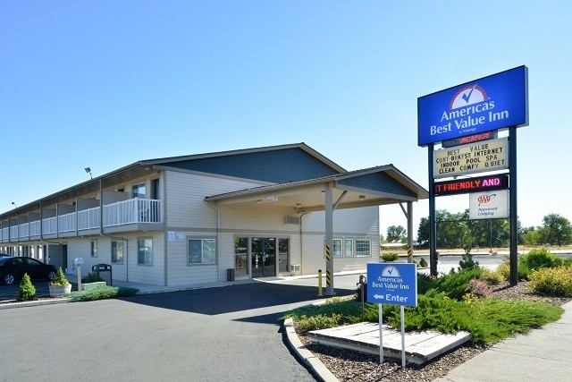
Property Record
999 Oregon Ave, Burns, OR 97720

Property Detail
999 Oregon Ave
Commercialnec
Harney
CG
Oregon
2025
0.81 AC
2025
Oregon East Area
960101
Other Market Areas
17,096 SF
23S 30E 13CA 501
NEARBY LISTINGS FOR SALE OR LEASE
-
-
View all Burns listings for sale on LoopNet.com
DEMOGRAPHICS near 999 Oregon Ave
1 mile
3 mile
5 mile
2025 Total Population
2,009
4,989
5,193
2030 Population
1,975
4,879
5,078
Pop Growth 2025-2030
(1.69%)
(2.20%)
(2.21%)
Average Age
44
44
44
2025 Total Households
851
2,153
2,238
HH Growth 2025-2030
(1.76%)
(2.23%)
(2.23%)
Median Household Inc
$37,329
$42,313
$42,682
Avg Household Size
2.30
2.30
2.30
2025 Avg HH Vehicles
2.00
2.00
2.00
Median Home Value
$167,561
$183,124
$184,866
Median Year Built
1973
1971
1971
Nearby Places
Map Layers
Map Styles
 Street
 Aerial
Layers
 Traffic
 Biking
Places
Listings with unknown addresses are not visible on the map
- Restaurants
- Banks
- Shops
- Fitness
- Groceries
SALE & LEASE HISTORY
LISTING DATE
SALE/LEASE

Sep 26, 2017
For Sale
Sep 19, 2024
For Sale
Oct 28, 2019
For Sale
Mar 16, 2023
For Sale
Jul 02, 2020
For Sale
Aug 23, 2023
For Sale
Nearby Properties
Address
Land Use
TOTAL SIZE
Lot Size
Zoning
Address
Land Use
TOTAL SIZE
Lot Size
Zoning
1.92 AC
Address
Land Use
TOTAL SIZE
Lot Size
Zoning
16,500 SF
30.08 AC
PF
Address
Land Use
TOTAL SIZE
Lot Size
Zoning
30.14 AC
Address
Land Use
TOTAL SIZE
Lot Size
Zoning
233,460 SF
39.90 AC
I
Address
Land Use
TOTAL SIZE
Lot Size
Zoning
33,868 SF
8.37 AC
PF
Address
Land Use
TOTAL SIZE
Lot Size
Zoning
35,480 SF
6.55 AC
RS
Address
Land Use
TOTAL SIZE
Lot Size
Zoning
22,172 SF
0.92 AC
PF
Address
Land Use
TOTAL SIZE
Lot Size
Zoning
1.43 AC
Address
Land Use
TOTAL SIZE
Lot Size
Zoning
33,088 SF
2.71 AC
C
Address
Land Use
TOTAL SIZE
Lot Size
Zoning
0.54 AC
Address
Land Use
TOTAL SIZE
Lot Size
Zoning
34,782 SF
2.19 AC
CG
Address
Land Use
TOTAL SIZE
Lot Size
Zoning
2.71 AC
RM
Address
Land Use
TOTAL SIZE
Lot Size
Zoning
27,528 SF
2.03 AC
C
Address
Land Use
TOTAL SIZE
Lot Size
Zoning
50,230 SF
2.33 AC
Address
Land Use
TOTAL SIZE
Lot Size
Zoning
9,651 SF
1.38 AC
PF
Address
Land Use
TOTAL SIZE
Lot Size
Zoning
14,802 SF
2.40 AC
RM
Address
Land Use
TOTAL SIZE
Lot Size
Zoning
24,956 SF
6.98 AC
C
Address
Land Use
TOTAL SIZE
Lot Size
Zoning
16,809 SF
3.29 AC
C
Address
Land Use
TOTAL SIZE
Lot Size
Zoning
8,700 SF
5.03 AC
Address
Land Use
TOTAL SIZE
Lot Size
Zoning
3,922 SF
0.92 AC
RS
Address
Land Use
TOTAL SIZE
Lot Size
Zoning
520 SF
441.70 AC
Address
Land Use
TOTAL SIZE
Lot Size
Zoning
19,992 SF
2.11 AC
C
Address
Land Use
TOTAL SIZE
Lot Size
Zoning
3,894 SF
1 AC
CG
Address
Land Use
TOTAL SIZE
Lot Size
Zoning
1.56 AC
RM
Address
Land Use
TOTAL SIZE
Lot Size
Zoning
Address
Land Use
TOTAL SIZE
Lot Size
Zoning
7,827 SF
1.24 AC
PF
Address
Land Use
TOTAL SIZE
Lot Size
Zoning
6,480 SF
7.51 AC
C
Address
Land Use
TOTAL SIZE
Lot Size
Zoning
0.23 AC
Address
Land Use
TOTAL SIZE
Lot Size
Zoning
3,120 SF
3.59 AC
C
The World's #1 Commercial Real Estate Marketplace
Connect with us
© 2026 CoStar Group
The information above has been obtained from sources believed reliable. While we do not doubt its accuracy we have not verified it and make no guarantee, warranty or representation about it. It is your responsibility to independently confirm its accuracy and completeness. Any projections, opinions, assumptions, or estimates used are for example only and do not represent the current or future performance of the property. The value of this transaction to you depends on tax and other factors which should be evaluated by your tax, financial, and legal advisors. You and your advisors should conduct a careful, independent investigation of the property to determine to your satisfaction the suitability of the property for your needs.