Property Record
999 Settles Rd, Suwanee, GA 30024

This Property Is For Sale
NEARBY LISTINGS FOR SALE OR LEASE
Property Detail
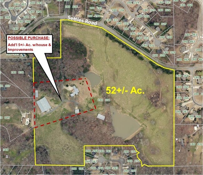
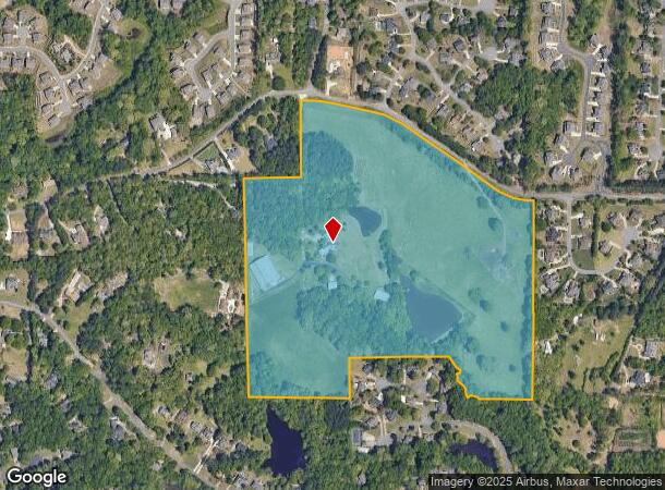
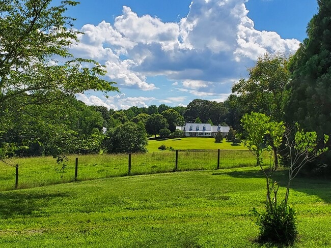
999 Settles Rd
Atlanta-Sandy Springs-Roswell, GA
South Forsyth
180-071
2-1 1003-1013-1014 COMB 180-72----1997 OWN/RETURN
Agriculturalland
Forsyth
X
Georgia
13117C0232F
1003
2024
56.59 AC
2025
N Fulton/Forsyth County
130611
Atlanta
3,626 SF
DEMOGRAPHICS near 999 Settles Rd
1 Mile
3 Mile
5 Mile
2024 Total Population
6,248
58,854
164,169
2029 Population
7,213
66,281
179,917
Pop Growth 2024-2029
+ 15.44%
+ 12.62%
+ 9.59%
Average Age
39
38
38
2024 Total Households
1,853
17,755
52,694
HH Growth 2024-2029
+ 15.43%
+ 12.72%
+ 9.58%
Median Household Inc
$171,012
$155,273
$139,578
Avg Household Size
3.30
3.30
3.10
2024 Avg HH Vehicles
3.00
2.00
2.00
Median Home Value
$608,095
$553,875
$468,249
Median Year Built
1997
2003
2001
Nearby Places
- Restaurants
- Banks
- Shops
- Fitness
- Groceries
Nearby Properties
Address
Land Use
TOTAL SIZE
Lot Size
Zoning
Address
Land Use
TOTAL SIZE
Lot Size
Zoning
424,176 SF
59.62 AC
R3
Address
Land Use
TOTAL SIZE
Lot Size
Zoning
370,414 SF
14.34 AC
PMUD
Address
Land Use
TOTAL SIZE
Lot Size
Zoning
47,721 SF
12.99 AC
CBD
Address
Land Use
TOTAL SIZE
Lot Size
Zoning
99,600 SF
91.27 AC
CR1
Address
Land Use
TOTAL SIZE
Lot Size
Zoning
291,232 SF
71.66 AC
RES3
Address
Land Use
TOTAL SIZE
Lot Size
Zoning
408 SF
217.12 AC
R100
Address
Land Use
TOTAL SIZE
Lot Size
Zoning
186,015 SF
13.72 AC
MP
Address
Land Use
TOTAL SIZE
Lot Size
Zoning
1,682 SF
303.40 AC
A1
Address
Land Use
TOTAL SIZE
Lot Size
Zoning
115,555 SF
34.65 AC
R100MOD
Address
Land Use
TOTAL SIZE
Lot Size
Zoning
14,880 SF
16.51 AC
CBD
Address
Land Use
TOTAL SIZE
Lot Size
Zoning
101,510 SF
15.45 AC
CBD
Address
Land Use
TOTAL SIZE
Lot Size
Zoning
45,603 SF
8.36 AC
CBD
Address
Land Use
TOTAL SIZE
Lot Size
Zoning
73,022 SF
6.57 AC
CBD
Address
Land Use
TOTAL SIZE
Lot Size
Zoning
3,366 SF
20.07 AC
PUD
Address
Land Use
TOTAL SIZE
Lot Size
Zoning
73,963 SF
10.57 AC
CBD
Address
Land Use
TOTAL SIZE
Lot Size
Zoning
126,920 SF
12.25 AC
M1
Address
Land Use
TOTAL SIZE
Lot Size
Zoning
98,593 SF
34.52 AC
R2R
Address
Land Use
TOTAL SIZE
Lot Size
Zoning
99,972 SF
5.61 AC
CBD
Address
Land Use
TOTAL SIZE
Lot Size
Zoning
772.94 AC
MINE
Address
Land Use
TOTAL SIZE
Lot Size
Zoning
18,344 SF
58.35 AC
R2R
Address
Land Use
TOTAL SIZE
Lot Size
Zoning
67,580 SF
10.60 AC
CBD
Address
Land Use
TOTAL SIZE
Lot Size
Zoning
133,842 SF
27.23 AC
CR1
Address
Land Use
TOTAL SIZE
Lot Size
Zoning
67,006 SF
11.59 AC
CBD
Address
Land Use
TOTAL SIZE
Lot Size
Zoning
100 SF
121.48 AC
A1
Address
Land Use
TOTAL SIZE
Lot Size
Zoning
97,794 SF
13.27 AC
M1
Address
Land Use
TOTAL SIZE
Lot Size
Zoning
212,566 SF
23.68 AC
CBD
Address
Land Use
TOTAL SIZE
Lot Size
Zoning
1,872 SF
9.33 AC
CBD
Address
Land Use
TOTAL SIZE
Lot Size
Zoning
120,200 SF
9.04 AC
M1
Address
Land Use
TOTAL SIZE
Lot Size
Zoning
64,432 SF
4.97 AC
CBD
Address
Land Use
TOTAL SIZE
Lot Size
Zoning
124,557 SF
11.60 AC
M1
The World's #1 Commercial Real Estate Marketplace
Connect with us
© 2025 CoStar Group
The information above has been obtained from sources believed reliable. While we do not doubt its accuracy we have not verified it and make no guarantee, warranty or representation about it. It is your responsibility to independently confirm its accuracy and completeness. Any projections, opinions, assumptions, or estimates used are for example only and do not represent the current or future performance of the property. The value of this transaction to you depends on tax and other factors which should be evaluated by your tax, financial, and legal advisors. You and your advisors should conduct a careful, independent investigation of the property to determine to your satisfaction the suitability of the property for your needs.