Property Record
999 Waterside Dr, Norfolk, VA 23510


Save to a Folder
{{folder.Name}}
{{folder.ListingIds.length}} Properties
{{folder.ListingIds.length}} Property
Create a New Folder
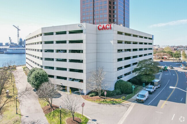
Property Detail
999 Waterside Dr
32757306
95 A-2
Officebuilding
Norfolk City
D1
Virginia
AE The base floodplain where base flood elevations are provided. AE Zones are now used on new format FIRMs instead of A1-A30 Zones.
2.64 AC
2025
Downtown Norfolk
2025
Hampton Roads
004900
Virginia Beach-Chesapeake-Norfolk, VA-NC
421,856 SF
NEARBY LISTINGS FOR SALE OR LEASE
DEMOGRAPHICS near 999 Waterside Dr
1 mile
3 mile
5 mile
2025 Total Population
12,613
112,765
253,728
2030 Population
12,357
112,452
252,130
Pop Growth 2025-2030
(2.03%)
(0.28%)
(0.63%)
Average Age
37
37
38
2025 Total Households
6,490
45,902
102,935
HH Growth 2025-2030
(1.85%)
(0.47%)
(0.76%)
Median Household Inc
$67,278
$54,850
$61,078
Avg Household Size
1.80
2.20
2.30
2025 Avg HH Vehicles
1.00
1.00
2.00
Median Home Value
$363,942
$277,420
$276,469
Median Year Built
1970
1964
1966
Nearby Places
Map Layers
Map Styles
 Street
 Aerial
Layers
 Traffic
 Biking
Places
Listings with unknown addresses are not visible on the map
- Restaurants
- Banks
- Shops
- Fitness
- Groceries
PUBLIC TRANSPORTATION
TRANSIT/SUBWAY
Civic Plaza (Tide Light Rail - Hampton Roads Transit (HRT))
Drive
Walk
Distance
Civic Plaza (Tide Light Rail - Hampton Roads Transit (HRT))
0 min
5 min
0.2 mi
Macarthur Square (Tide Light Rail - Hampton Roads Transit (HRT))
Drive
Walk
Distance
Macarthur Square (Tide Light Rail - Hampton Roads Transit (HRT))
1 min
7 min
0.4 mi
Harbor Park (Tide Light Rail - Hampton Roads Transit (HRT))
Drive
Walk
Distance
Harbor Park (Tide Light Rail - Hampton Roads Transit (HRT))
2 min
11 min
0.6 mi
Monticello (LIGHT RAIL TIDE - Hampton Roads Transit (HRT))
Drive
Walk
Distance
Monticello (LIGHT RAIL TIDE - Hampton Roads Transit (HRT))
2 min
13 min
0.7 mi
COMMUTER RAIL
Norfolk (Northeast Regional - Amtrak)
Drive
Walk
Distance
Norfolk (Northeast Regional - Amtrak)
2 min
14 min
0.7 mi
AIRPORT
Norfolk International
Drive
Walk
Distance
Norfolk International
14 min
7.3 mi
Newport News/Williamsburg International
Drive
Walk
Distance
Newport News/Williamsburg International
43 min
28.8 mi
Freight Ports
Virginia Port Authority - Portsmouth
Drive
Walk
Distance
Virginia Port Authority - Portsmouth
13 min
5.4 mi
Nearby Properties
Address
Land Use
TOTAL SIZE
Lot Size
Zoning
Address
Land Use
TOTAL SIZE
Lot Size
Zoning
331,760 SF
24.97 AC
Address
Land Use
TOTAL SIZE
Lot Size
Zoning
5,704 SF
4.67 AC
D2
Address
Land Use
TOTAL SIZE
Lot Size
Zoning
85,756 SF
3.59 AC
D5
Address
Land Use
TOTAL SIZE
Lot Size
Zoning
421,540 SF
2.37 AC
Address
Land Use
TOTAL SIZE
Lot Size
Zoning
192,422 SF
10.70 AC
D4
Address
Land Use
TOTAL SIZE
Lot Size
Zoning
250,766 SF
31.14 AC
NMU
Address
Land Use
TOTAL SIZE
Lot Size
Zoning
390,960 SF
4.43 AC
Address
Land Use
TOTAL SIZE
Lot Size
Zoning
390,960 SF
4.43 AC
Address
Land Use
TOTAL SIZE
Lot Size
Zoning
73,136 SF
5.34 AC
IN2
Address
Land Use
TOTAL SIZE
Lot Size
Zoning
55.11 AC
IN2
Address
Land Use
TOTAL SIZE
Lot Size
Zoning
92.17 AC
OSP
Address
Land Use
TOTAL SIZE
Lot Size
Zoning
971,654 SF
6.01 AC
D2
Address
Land Use
TOTAL SIZE
Lot Size
Zoning
310,912 SF
3.94 AC
Address
Land Use
TOTAL SIZE
Lot Size
Zoning
689,954 SF
63.25 AC
Address
Land Use
TOTAL SIZE
Lot Size
Zoning
473,072 SF
9.72 AC
SD
Address
Land Use
TOTAL SIZE
Lot Size
Zoning
258,000 SF
1.38 AC
M2: GENERA
Address
Land Use
TOTAL SIZE
Lot Size
Zoning
192,270 SF
1.99 AC
D2
Address
Land Use
TOTAL SIZE
Lot Size
Zoning
126,088 SF
4.91 AC
C2
Address
Land Use
TOTAL SIZE
Lot Size
Zoning
363,974 SF
1.49 AC
Address
Land Use
TOTAL SIZE
Lot Size
Zoning
66,718 SF
4.09 AC
D5
Address
Land Use
TOTAL SIZE
Lot Size
Zoning
4.92 AC
IN1
Address
Land Use
TOTAL SIZE
Lot Size
Zoning
356,598 SF
1.84 AC
D2
Address
Land Use
TOTAL SIZE
Lot Size
Zoning
50,384 SF
0.74 AC
Address
Land Use
TOTAL SIZE
Lot Size
Zoning
291,748 SF
3.40 AC
G1
Address
Land Use
TOTAL SIZE
Lot Size
Zoning
252,524 SF
20 AC
R8S: RESID
Address
Land Use
TOTAL SIZE
Lot Size
Zoning
79,577 SF
3.04 AC
C2
Address
Land Use
TOTAL SIZE
Lot Size
Zoning
35,091 SF
0.71 AC
Address
Land Use
TOTAL SIZE
Lot Size
Zoning
197,074 SF
6.69 AC
Address
Land Use
TOTAL SIZE
Lot Size
Zoning
640,920 SF
3.67 AC
HCEF
The World's #1 Commercial Real Estate Marketplace
Connect with us
© 2026 CoStar Group
The information above has been obtained from sources believed reliable. While we do not doubt its accuracy we have not verified it and make no guarantee, warranty or representation about it. It is your responsibility to independently confirm its accuracy and completeness. Any projections, opinions, assumptions, or estimates used are for example only and do not represent the current or future performance of the property. The value of this transaction to you depends on tax and other factors which should be evaluated by your tax, financial, and legal advisors. You and your advisors should conduct a careful, independent investigation of the property to determine to your satisfaction the suitability of the property for your needs.