Property Record
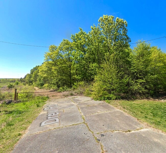
Lucia Riverbend Hwy, Stanley, NC 28164

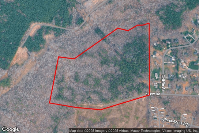
This Property Is For Sale
Property Detail
Lucia Riverbend Hwy
172756
14 011 003 00 000
Vacantlandnec
GASTON
R1
North Carolina
B and X Area of moderate flood hazard, usually the area between the limits of the 100-year and 500-year floods.
58.54 AC
2025
Gaston County
2025
Charlotte
030203
Charlotte-Concord-Gastonia, NC-SC
NEARBY LISTINGS FOR SALE OR LEASE
-
-
View all Stanley listings for sale on LoopNet.com
DEMOGRAPHICS near Lucia Riverbend Hwy
1 mile
3 mile
5 mile
2025 Total Population
1,010
5,752
27,692
2030 Population
1,071
6,152
30,025
Pop Growth 2025-2030
+ 6.04%
+ 6.95%
+ 8.42%
Average Age
45
44
43
2025 Total Households
429
2,321
10,833
HH Growth 2025-2030
+ 6.06%
+ 7.15%
+ 8.64%
Median Household Inc
$90,140
$94,313
$96,377
Avg Household Size
2.40
2.50
2.50
2025 Avg HH Vehicles
2.00
2.00
2.00
Median Home Value
$379,166
$371,020
$401,483
Median Year Built
1987
1994
2000
Nearby Places
Map Layers
Map Styles
 Street
 Aerial
Transit
 Traffic
 Biking
Places
Listings with unknown addresses are not visible on the map
- Restaurants
- Banks
- Shops
- Fitness
- Groceries
PUBLIC TRANSPORTATION
AIRPORT
Charlotte/Douglas International
Drive
Walk
Distance
Charlotte/Douglas International
31 min
16.8 mi
Concord-Padgett Regional
Drive
Walk
Distance
Concord-Padgett Regional
31 min
22.2 mi
Freight Ports
North Charleston Terminal
Drive
Walk
Distance
North Charleston Terminal
242 min
212.7 mi
Nearby Properties
Address
Land Use
TOTAL SIZE
Lot Size
Zoning
Address
Land Use
TOTAL SIZE
Lot Size
Zoning
44,424 SF
36.31 AC
ELDD PD-I
Address
Land Use
TOTAL SIZE
Lot Size
Zoning
4,506 SF
38.05 AC
I-G & R-T
Address
Land Use
TOTAL SIZE
Lot Size
Zoning
637.85 AC
R-T & PD-I
Address
Land Use
TOTAL SIZE
Lot Size
Zoning
93,840 SF
32.50 AC
ELDD I-G
Address
Land Use
TOTAL SIZE
Lot Size
Zoning
1,500 SF
24.66 AC
Address
Land Use
TOTAL SIZE
Lot Size
Zoning
6,506 SF
312.12 AC
R1
Address
Land Use
TOTAL SIZE
Lot Size
Zoning
424.03 AC
R1
Address
Land Use
TOTAL SIZE
Lot Size
Zoning
5,195 SF
8.09 AC
ELDD B-G
Address
Land Use
TOTAL SIZE
Lot Size
Zoning
15,354 SF
28.48 AC
ELDD I-G
Address
Land Use
TOTAL SIZE
Lot Size
Zoning
13,222 SF
31.38 AC
CHUR2
Address
Land Use
TOTAL SIZE
Lot Size
Zoning
261.96 AC
PD-MU
Address
Land Use
TOTAL SIZE
Lot Size
Zoning
57.29 AC
R-T
Address
Land Use
TOTAL SIZE
Lot Size
Zoning
5,366 SF
125.67 AC
R1
Address
Land Use
TOTAL SIZE
Lot Size
Zoning
235.90 AC
I-G CU
Address
Land Use
TOTAL SIZE
Lot Size
Zoning
26,807 SF
10.38 AC
CHUR2
Address
Land Use
TOTAL SIZE
Lot Size
Zoning
7,500 SF
3.62 AC
ELDD I-G
Address
Land Use
TOTAL SIZE
Lot Size
Zoning
45,741 SF
2.84 AC
ELDD I-G
Address
Land Use
TOTAL SIZE
Lot Size
Zoning
1,200 SF
18.85 AC
Address
Land Use
TOTAL SIZE
Lot Size
Zoning
194.23 AC
Address
Land Use
TOTAL SIZE
Lot Size
Zoning
3,400 SF
117.67 AC
R-T
Address
Land Use
TOTAL SIZE
Lot Size
Zoning
9,016 SF
1.47 AC
ELDD B-N
Address
Land Use
TOTAL SIZE
Lot Size
Zoning
10,256 SF
4.24 AC
ELDD I-G
Address
Land Use
TOTAL SIZE
Lot Size
Zoning
90.03 AC
R-SF
Address
Land Use
TOTAL SIZE
Lot Size
Zoning
91.75 AC
R-T
Address
Land Use
TOTAL SIZE
Lot Size
Zoning
1,292 SF
36.78 AC
PD-R & R-T
Address
Land Use
TOTAL SIZE
Lot Size
Zoning
1,701 SF
294.17 AC
R1U
Address
Land Use
TOTAL SIZE
Lot Size
Zoning
1,600 SF
12.86 AC
I-G CU
Address
Land Use
TOTAL SIZE
Lot Size
Zoning
3,274 SF
5.04 AC
R1
Address
Land Use
TOTAL SIZE
Lot Size
Zoning
2,850 SF
15.25 AC
ELDD R-SF
Address
Land Use
TOTAL SIZE
Lot Size
Zoning
11,200 SF
2.66 AC
ELDD R-T
The World's #1 Commercial Real Estate Marketplace
Connect with us
© 2026 CoStar Group
The information above has been obtained from sources believed reliable. While we do not doubt its accuracy we have not verified it and make no guarantee, warranty or representation about it. It is your responsibility to independently confirm its accuracy and completeness. Any projections, opinions, assumptions, or estimates used are for example only and do not represent the current or future performance of the property. The value of this transaction to you depends on tax and other factors which should be evaluated by your tax, financial, and legal advisors. You and your advisors should conduct a careful, independent investigation of the property to determine to your satisfaction the suitability of the property for your needs.