Property Record
12801 S Us Highway 95 Hwy, Henderson, NV 89002
Property Detail
12801 S Us Highway 95 Hwy
Las Vegas-Henderson-North Las Vegas, NV
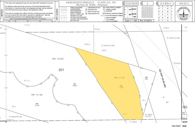
PARCEL MAP FILE 116 PAGE 65 LOT 2-1
189-02-201-007
CLARK
Vacantlandnec
Nevada
RH24
2
B and X Area of moderate flood hazard, usually the area between the limits of the 100-year and 500-year floods.
44.36 AC
2026
SE Las Vegas/Henderson
2026
Las Vegas
005360
NEARBY LISTINGS FOR SALE OR LEASE
DEMOGRAPHICS near 12801 S Us Highway 95 Hwy
1 mile
3 mile
5 mile
2025 Total Population
1,744
19,600
72,507
2030 Population
1,887
20,717
76,430
Pop Growth 2025-2030
+ 8.20%
+ 5.70%
+ 5.41%
Average Age
39
40
42
2025 Total Households
715
7,273
27,397
HH Growth 2025-2030
+ 8.25%
+ 5.83%
+ 5.53%
Median Household Inc
$74,847
$90,183
$90,041
Avg Household Size
2.40
2.60
2.60
2025 Avg HH Vehicles
2.00
2.00
2.00
Median Home Value
$630,435
$479,439
$458,433
Median Year Built
2005
2001
1996
Nearby Places
Map Layers
Map Styles
 Street
 Aerial
Transit
 Traffic
 Biking
Places
Listings with unknown addresses are not visible on the map
- Restaurants
- Banks
- Shops
- Fitness
- Groceries
PUBLIC TRANSPORTATION
AIRPORT
Boulder City Municipal
Drive
Walk
Distance
Boulder City Municipal
12 min
5.7 mi
Harry Reid International
Drive
Walk
Distance
Harry Reid International
28 min
19.0 mi
Freight Ports
Port of Long Beach
Drive
Walk
Distance
Port of Long Beach
326 min
287.7 mi
Nearby Properties
Address
Land Use
TOTAL SIZE
Lot Size
Zoning
Address
Land Use
TOTAL SIZE
Lot Size
Zoning
917,210 SF
60.42 AC
Address
Land Use
TOTAL SIZE
Lot Size
Zoning
295,238 SF
23.49 AC
IP
Address
Land Use
TOTAL SIZE
Lot Size
Zoning
30.74 AC
H
Address
Land Use
TOTAL SIZE
Lot Size
Zoning
4,627 SF
7.01 AC
MC
Address
Land Use
TOTAL SIZE
Lot Size
Zoning
51,777 SF
261.30 AC
SR
Address
Land Use
TOTAL SIZE
Lot Size
Zoning
2,650 SF
11.93 AC
H:RM-16-MP
Address
Land Use
TOTAL SIZE
Lot Size
Zoning
10.01 AC
PS
Address
Land Use
TOTAL SIZE
Lot Size
Zoning
416 SF
320 AC
PS
Address
Land Use
TOTAL SIZE
Lot Size
Zoning
Address
Land Use
TOTAL SIZE
Lot Size
Zoning
510.81 AC
Address
Land Use
TOTAL SIZE
Lot Size
Zoning
41,199 SF
39.37 AC
Address
Land Use
TOTAL SIZE
Lot Size
Zoning
122,482 SF
157.34 AC
RU
Address
Land Use
TOTAL SIZE
Lot Size
Zoning
411,144 SF
22.69 AC
IP
Address
Land Use
TOTAL SIZE
Lot Size
Zoning
320 AC
DH
Address
Land Use
TOTAL SIZE
Lot Size
Zoning
2,450 SF
4.95 AC
MC
Address
Land Use
TOTAL SIZE
Lot Size
Zoning
15.64 AC
PS
Address
Land Use
TOTAL SIZE
Lot Size
Zoning
32,996 SF
23.62 AC
Address
Land Use
TOTAL SIZE
Lot Size
Zoning
Address
Land Use
TOTAL SIZE
Lot Size
Zoning
81,519 SF
3.50 AC
IP
Address
Land Use
TOTAL SIZE
Lot Size
Zoning
15,999 SF
10.29 AC
Address
Land Use
TOTAL SIZE
Lot Size
Zoning
148.64 AC
RU
Address
Land Use
TOTAL SIZE
Lot Size
Zoning
8,203 SF
14.87 AC
Address
Land Use
TOTAL SIZE
Lot Size
Zoning
191,805 SF
7.01 AC
IP
Address
Land Use
TOTAL SIZE
Lot Size
Zoning
1,170 SF
26.39 AC
PS
Address
Land Use
TOTAL SIZE
Lot Size
Zoning
16.62 AC
IP
Address
Land Use
TOTAL SIZE
Lot Size
Zoning
7,119 SF
10.51 AC
PS
Address
Land Use
TOTAL SIZE
Lot Size
Zoning
93,137 SF
4.50 AC
Address
Land Use
TOTAL SIZE
Lot Size
Zoning
Address
Land Use
TOTAL SIZE
Lot Size
Zoning
28,847 SF
4.44 AC
MC
The World's #1 Commercial Real Estate Marketplace
Connect with us
© 2026 CoStar Group
The information above has been obtained from sources believed reliable. While we do not doubt its accuracy we have not verified it and make no guarantee, warranty or representation about it. It is your responsibility to independently confirm its accuracy and completeness. Any projections, opinions, assumptions, or estimates used are for example only and do not represent the current or future performance of the property. The value of this transaction to you depends on tax and other factors which should be evaluated by your tax, financial, and legal advisors. You and your advisors should conduct a careful, independent investigation of the property to determine to your satisfaction the suitability of the property for your needs.