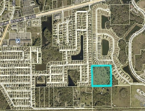
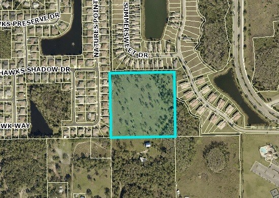
Property Record
Access Undetermined, Alva, FL 33920

Save to a Folder
{{folder.Name}}
{{folder.ListingIds.length}} Properties
{{folder.ListingIds.length}} Property
Create a New Folder
Property Detail
Access Undetermined
27-43-26-00-00020.0000
SW 1/4 OF NW 1/4 OF SW 1/4
Residentialacreage
LEE
AG-2
Florida
AE The base floodplain where base flood elevations are provided. AE Zones are now used on new format FIRMs instead of A1-A30 Zones.
10 AC
2025
City of Ft Myers
2026
Southwest Florida
030300
Cape Coral-Fort Myers, FL
NEARBY LISTINGS FOR SALE OR LEASE
DEMOGRAPHICS near Access Undetermined
1 mile
3 mile
5 mile
2025 Total Population
3,521
20,142
35,170
2030 Population
3,920
22,384
39,019
Pop Growth 2025-2030
+ 11.33%
+ 11.13%
+ 10.94%
Average Age
43
44
42
2025 Total Households
1,336
7,831
12,983
HH Growth 2025-2030
+ 10.63%
+ 10.50%
+ 10.40%
Median Household Inc
$87,184
$84,060
$82,529
Avg Household Size
2.50
2.50
2.60
2025 Avg HH Vehicles
2.00
2.00
2.00
Median Home Value
$391,184
$416,537
$398,443
Median Year Built
2006
2004
2004
Nearby Places
Map Layers
Map Styles
 Street
 Aerial
Layers
 Traffic
 Biking
Places
Listings with unknown addresses are not visible on the map
- Restaurants
- Banks
- Shops
- Fitness
- Groceries
PUBLIC TRANSPORTATION
AIRPORT
Southwest Florida International
Drive
Walk
Distance
Southwest Florida International
29 min
15.3 mi
Punta Gorda
Drive
Walk
Distance
Punta Gorda
37 min
27.8 mi
SALE & LEASE HISTORY
LISTING DATE
SALE/LEASE

Nov 07, 2018
For Sale
Nearby Properties
Address
Land Use
TOTAL SIZE
Lot Size
Zoning
Address
Land Use
TOTAL SIZE
Lot Size
Zoning
254,384 SF
42.57 AC
AG-2
Address
Land Use
TOTAL SIZE
Lot Size
Zoning
149,757 SF
20 AC
AG-2
Address
Land Use
TOTAL SIZE
Lot Size
Zoning
3,111.65 AC
AG-2
Address
Land Use
TOTAL SIZE
Lot Size
Zoning
1.56 AC
CPD
Address
Land Use
TOTAL SIZE
Lot Size
Zoning
51,512 SF
128.26 AC
AG-2
Address
Land Use
TOTAL SIZE
Lot Size
Zoning
56,189 SF
5.51 AC
CC
Address
Land Use
TOTAL SIZE
Lot Size
Zoning
85.68 AC
Address
Land Use
TOTAL SIZE
Lot Size
Zoning
40,378 SF
21.23 AC
AG-2
Address
Land Use
TOTAL SIZE
Lot Size
Zoning
0.96 AC
C-2
Address
Land Use
TOTAL SIZE
Lot Size
Zoning
34,257 SF
14.87 AC
AG-2
Address
Land Use
TOTAL SIZE
Lot Size
Zoning
59,438 SF
8.95 AC
CPD
Address
Land Use
TOTAL SIZE
Lot Size
Zoning
426.40 AC
AG-2
Address
Land Use
TOTAL SIZE
Lot Size
Zoning
41,605 SF
14.31 AC
MPD
Address
Land Use
TOTAL SIZE
Lot Size
Zoning
16,065 SF
2.36 AC
MPD
Address
Land Use
TOTAL SIZE
Lot Size
Zoning
25,884 SF
4.83 AC
CC
Address
Land Use
TOTAL SIZE
Lot Size
Zoning
320 SF
201.17 AC
CG
Address
Land Use
TOTAL SIZE
Lot Size
Zoning
36,371 SF
4.90 AC
CC
Address
Land Use
TOTAL SIZE
Lot Size
Zoning
5,963 SF
2.67 AC
C-1
Address
Land Use
TOTAL SIZE
Lot Size
Zoning
24,849 SF
6.29 AC
CFPD
Address
Land Use
TOTAL SIZE
Lot Size
Zoning
15,427 SF
21.38 AC
AG-2
Address
Land Use
TOTAL SIZE
Lot Size
Zoning
12,523 SF
2 AC
C-1
Address
Land Use
TOTAL SIZE
Lot Size
Zoning
46,998 SF
10.60 AC
CFPD
Address
Land Use
TOTAL SIZE
Lot Size
Zoning
2.25 AC
CPD
Address
Land Use
TOTAL SIZE
Lot Size
Zoning
12,802 SF
1.43 AC
C-1
Address
Land Use
TOTAL SIZE
Lot Size
Zoning
6,435 SF
27.17 AC
AG-2
Address
Land Use
TOTAL SIZE
Lot Size
Zoning
3.44 AC
CPD
Address
Land Use
TOTAL SIZE
Lot Size
Zoning
14,835 SF
2.68 AC
CPD
Address
Land Use
TOTAL SIZE
Lot Size
Zoning
9,284 SF
1.86 AC
CC
Address
Land Use
TOTAL SIZE
Lot Size
Zoning
27,572 SF
1.66 AC
C-1
Address
Land Use
TOTAL SIZE
Lot Size
Zoning
3,217 SF
0.76 AC
CPD
The World's #1 Commercial Real Estate Marketplace
Connect with us
© 2026 CoStar Group
The information above has been obtained from sources believed reliable. While we do not doubt its accuracy we have not verified it and make no guarantee, warranty or representation about it. It is your responsibility to independently confirm its accuracy and completeness. Any projections, opinions, assumptions, or estimates used are for example only and do not represent the current or future performance of the property. The value of this transaction to you depends on tax and other factors which should be evaluated by your tax, financial, and legal advisors. You and your advisors should conduct a careful, independent investigation of the property to determine to your satisfaction the suitability of the property for your needs.