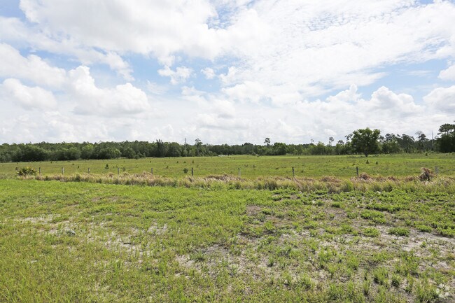
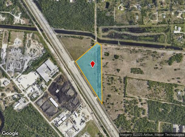
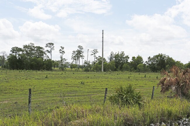
Property Record
Access Undetermined, Fort Myers, FL 33912
NEARBY LISTINGS FOR SALE OR LEASE
Property Detail
Access Undetermined
Cape Coral-Fort Myers, FL
S. 41 Corridor
06-46-25-00-00003.0080
PARL IN W 1/2 OF SEC 6 TWP 46 R 25 DESC IN OR 1220 PG 607 LS PAR 3.008A LESS R/W OR 3851 PG 2943
Pasture
Lee
AE
Florida
12071C0438H
20&21
2024
10.08 AC
2025
S Ft Myers/San Carlos
040113
Southwest Florida
DEMOGRAPHICS near Access Undetermined
1 Mile
3 Mile
5 Mile
2024 Total Population
1,802
34,250
114,543
2029 Population
2,123
40,336
135,593
Pop Growth 2024-2029
+ 17.81%
+ 17.77%
+ 18.38%
Average Age
49
48
48
2024 Total Households
853
15,334
51,847
HH Growth 2024-2029
+ 17.47%
+ 17.46%
+ 18.14%
Median Household Inc
$72,379
$74,190
$68,913
Avg Household Size
2.10
2.20
2.10
2024 Avg HH Vehicles
2.00
2.00
2.00
Median Home Value
$305,147
$286,620
$271,111
Median Year Built
1987
1990
1992
Nearby Places
- Restaurants
- Banks
- Shops
- Fitness
- Groceries
PUBLIC TRANSPORTATION
AIRPORT
Southwest Florida International
DRIVE
WALK
Distance
Southwest Florida International
17 min
9.7 mi
Punta Gorda
DRIVE
WALK
Distance
Punta Gorda
45 min
35.8 mi
Freight Ports
Port Manatee
DRIVE
WALK
Distance
Port Manatee
125 min
107.5 mi
Nearby Properties
Address
Land Use
TOTAL SIZE
Lot Size
Zoning
Address
Land Use
TOTAL SIZE
Lot Size
Zoning
741,488 SF
23.22 AC
CPD
Address
Land Use
TOTAL SIZE
Lot Size
Zoning
462,334 SF
32.45 AC
MPD
Address
Land Use
TOTAL SIZE
Lot Size
Zoning
576,858 SF
77.73 AC
CF-2
Address
Land Use
TOTAL SIZE
Lot Size
Zoning
562,104 SF
18.98 AC
RPD
Address
Land Use
TOTAL SIZE
Lot Size
Zoning
15.08 AC
Address
Land Use
TOTAL SIZE
Lot Size
Zoning
346,817 SF
26.28 AC
MPD
Address
Land Use
TOTAL SIZE
Lot Size
Zoning
24,552 SF
71.20 AC
IPD
Address
Land Use
TOTAL SIZE
Lot Size
Zoning
34.63 AC
AG-2
Address
Land Use
TOTAL SIZE
Lot Size
Zoning
444,774 SF
36.07 AC
MPD
Address
Land Use
TOTAL SIZE
Lot Size
Zoning
270,752 SF
45.08 AC
IPD
Address
Land Use
TOTAL SIZE
Lot Size
Zoning
59,832 SF
4.23 AC
CPD
Address
Land Use
TOTAL SIZE
Lot Size
Zoning
33.21 AC
AG-2
Address
Land Use
TOTAL SIZE
Lot Size
Zoning
9,670 SF
9.12 AC
AG-2
Address
Land Use
TOTAL SIZE
Lot Size
Zoning
170,495 SF
7.80 AC
CPD
Address
Land Use
TOTAL SIZE
Lot Size
Zoning
10.50 AC
AG-2
Address
Land Use
TOTAL SIZE
Lot Size
Zoning
263,160 SF
19.96 AC
IPD
Address
Land Use
TOTAL SIZE
Lot Size
Zoning
198,225 SF
28.77 AC
IPD
Address
Land Use
TOTAL SIZE
Lot Size
Zoning
316,597 SF
19.19 AC
IPD
Address
Land Use
TOTAL SIZE
Lot Size
Zoning
7.06 AC
MPD
Address
Land Use
TOTAL SIZE
Lot Size
Zoning
129,016 SF
9.76 AC
CPD
Address
Land Use
TOTAL SIZE
Lot Size
Zoning
406,192 SF
2.75 AC
CPD
Address
Land Use
TOTAL SIZE
Lot Size
Zoning
2.54 AC
MPD
Address
Land Use
TOTAL SIZE
Lot Size
Zoning
21.13 AC
H
Address
Land Use
TOTAL SIZE
Lot Size
Zoning
180,386 SF
10.11 AC
IPD
Address
Land Use
TOTAL SIZE
Lot Size
Zoning
118,193 SF
11.05 AC
CPD
Address
Land Use
TOTAL SIZE
Lot Size
Zoning
122,339 SF
19.39 AC
RPD
Address
Land Use
TOTAL SIZE
Lot Size
Zoning
221,486 SF
74.60 AC
PUD
Address
Land Use
TOTAL SIZE
Lot Size
Zoning
126,768 SF
11.87 AC
CPD
Address
Land Use
TOTAL SIZE
Lot Size
Zoning
125,656 SF
20.82 AC
AG-2
Address
Land Use
TOTAL SIZE
Lot Size
Zoning
277,794 SF
47.85 AC
IPD
The World's #1 Commercial Real Estate Marketplace
Connect with us
© 2025 CoStar Group
The information above has been obtained from sources believed reliable. While we do not doubt its accuracy we have not verified it and make no guarantee, warranty or representation about it. It is your responsibility to independently confirm its accuracy and completeness. Any projections, opinions, assumptions, or estimates used are for example only and do not represent the current or future performance of the property. The value of this transaction to you depends on tax and other factors which should be evaluated by your tax, financial, and legal advisors. You and your advisors should conduct a careful, independent investigation of the property to determine to your satisfaction the suitability of the property for your needs.