Property Record
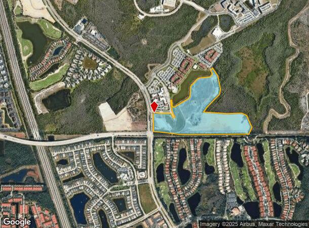
Access Undetermined, Fort Myers, FL 33913
NEARBY LISTINGS FOR SALE OR LEASE
Property Detail
Access Undetermined
Cape Coral-Fort Myers, FL
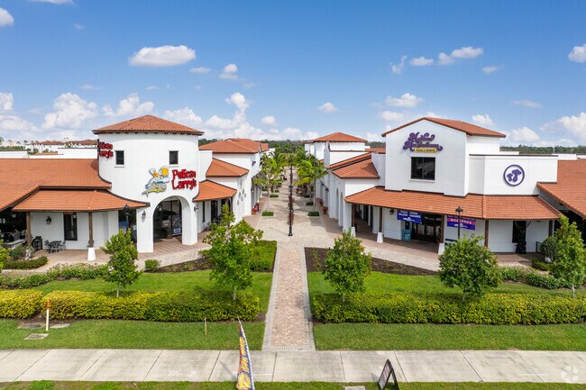
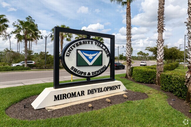
Miromar Lakes
24-46-25-L4-10FD2.0000
UNIVERSITY VILLAGE TRACT FD-2 AS DESC IN INST 2017000253716
Commercialacreage
Lee
X
Florida
12071C0584F
44.41 AC
2024
Estero
2025
Southwest Florida
980000
DEMOGRAPHICS near Access Undetermined
1 Mile
3 Mile
5 Mile
2024 Total Population
3,749
41,690
77,663
2029 Population
4,534
49,761
92,675
Pop Growth 2024-2029
+ 20.94%
+ 19.36%
+ 19.33%
Average Age
49
45
48
2024 Total Households
1,823
17,411
33,613
HH Growth 2024-2029
+ 20.63%
+ 19.30%
+ 19.26%
Median Household Inc
$91,569
$87,762
$85,575
Avg Household Size
1.90
2.30
2.20
2024 Avg HH Vehicles
2.00
2.00
2.00
Median Home Value
$441,065
$347,461
$341,510
Median Year Built
2009
2003
2002
Nearby Places
Map Layers
Map Styles
 Street
 Aerial
- Restaurants
- Banks
- Shops
- Fitness
- Groceries
PUBLIC TRANSPORTATION
AIRPORT
Southwest Florida International
DRIVE
WALK
Distance
Southwest Florida International
19 min
9.9 mi
Freight Ports
Port Manatee
DRIVE
WALK
Distance
Port Manatee
129 min
110.6 mi
SALE & LEASE HISTORY
LISTING DATE
SALE/LEASE

Feb 16, 2021
For Lease
Nearby Properties
Address
Land Use
TOTAL SIZE
Lot Size
Zoning
Address
Land Use
TOTAL SIZE
Lot Size
Zoning
4,413,774 SF
760.09 AC
AG-2
Address
Land Use
TOTAL SIZE
Lot Size
Zoning
Address
Land Use
TOTAL SIZE
Lot Size
Zoning
1,029,818 SF
83.07 AC
MPD
Address
Land Use
TOTAL SIZE
Lot Size
Zoning
100,557 SF
17.66 AC
CPD
Address
Land Use
TOTAL SIZE
Lot Size
Zoning
20.19 AC
MPD
Address
Land Use
TOTAL SIZE
Lot Size
Zoning
395,259 SF
16.56 AC
MPD
Address
Land Use
TOTAL SIZE
Lot Size
Zoning
420,851 SF
23.83 AC
MPD
Address
Land Use
TOTAL SIZE
Lot Size
Zoning
385,229 SF
16.69 AC
RPD
Address
Land Use
TOTAL SIZE
Lot Size
Zoning
369,577 SF
16.39 AC
RPD
Address
Land Use
TOTAL SIZE
Lot Size
Zoning
482,782 SF
27.98 AC
CPD
Address
Land Use
TOTAL SIZE
Lot Size
Zoning
294,689 SF
17.95 AC
MPD
Address
Land Use
TOTAL SIZE
Lot Size
Zoning
345,170 SF
21.32 AC
RPD
Address
Land Use
TOTAL SIZE
Lot Size
Zoning
291,157 SF
23.38 AC
RPD
Address
Land Use
TOTAL SIZE
Lot Size
Zoning
320,574 SF
16.10 AC
MPD
Address
Land Use
TOTAL SIZE
Lot Size
Zoning
245,356 SF
12.54 AC
MPD
Address
Land Use
TOTAL SIZE
Lot Size
Zoning
274,691 SF
6.62 AC
MPD
Address
Land Use
TOTAL SIZE
Lot Size
Zoning
348,757 SF
69.01 AC
CF-2
Address
Land Use
TOTAL SIZE
Lot Size
Zoning
240,044 SF
14.19 AC
MPD
Address
Land Use
TOTAL SIZE
Lot Size
Zoning
69.37 AC
RPD
Address
Land Use
TOTAL SIZE
Lot Size
Zoning
14.42 AC
RPD
Address
Land Use
TOTAL SIZE
Lot Size
Zoning
236,456 SF
27.05 AC
MPD
Address
Land Use
TOTAL SIZE
Lot Size
Zoning
239.40 AC
Address
Land Use
TOTAL SIZE
Lot Size
Zoning
76,548 SF
2.72 AC
MPD
Address
Land Use
TOTAL SIZE
Lot Size
Zoning
166,672 SF
8.58 AC
CPD
Address
Land Use
TOTAL SIZE
Lot Size
Zoning
79,833 SF
9.16 AC
Address
Land Use
TOTAL SIZE
Lot Size
Zoning
174,712 SF
9.70 AC
MPD
Address
Land Use
TOTAL SIZE
Lot Size
Zoning
16.16 AC
MPD
Address
Land Use
TOTAL SIZE
Lot Size
Zoning
87,959 SF
2.72 AC
MPD
Address
Land Use
TOTAL SIZE
Lot Size
Zoning
139,174 SF
4.73 AC
CPD
Address
Land Use
TOTAL SIZE
Lot Size
Zoning
247,870 SF
15.95 AC
MPD
The World's #1 Commercial Real Estate Marketplace
Connect with us
© 2025 CoStar Group
The information above has been obtained from sources believed reliable. While we do not doubt its accuracy we have not verified it and make no guarantee, warranty or representation about it. It is your responsibility to independently confirm its accuracy and completeness. Any projections, opinions, assumptions, or estimates used are for example only and do not represent the current or future performance of the property. The value of this transaction to you depends on tax and other factors which should be evaluated by your tax, financial, and legal advisors. You and your advisors should conduct a careful, independent investigation of the property to determine to your satisfaction the suitability of the property for your needs.