Property Record
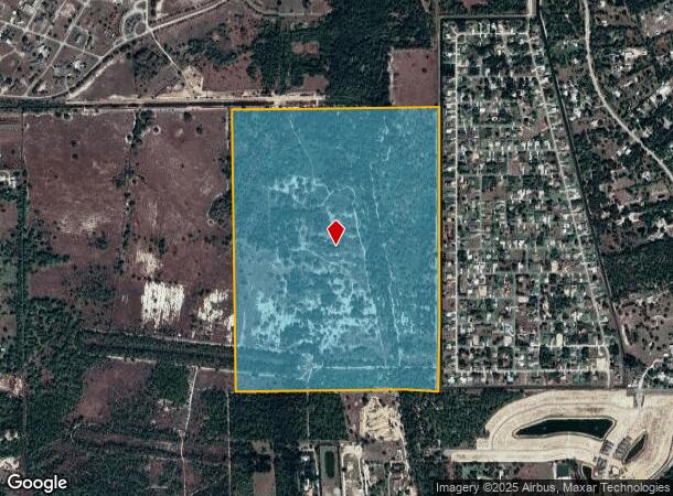
Access Undetermined, Fort Myers, FL
NEARBY LISTINGS FOR SALE OR LEASE
Property Detail
Access Undetermined
Cape Coral-Fort Myers, FL
East Of I-75 Buckingham
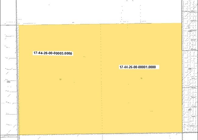
17-44-26-00-00001.0000
PARL IN E 1/2 SEC 17 T44 R26 DESC IN OR 1354 PG 1251
Vacantlandnec
Lee
X
Florida
12071C0313F
213.91 AC
0
City of Ft Myers
2025
Southwest Florida
040123
DEMOGRAPHICS near Access Undetermined
1 Mile
3 Mile
5 Mile
2024 Total Population
1,832
27,855
96,173
2029 Population
2,146
32,749
114,079
Pop Growth 2024-2029
+ 17.14%
+ 17.57%
+ 18.62%
Average Age
36
35
39
2024 Total Households
612
8,762
33,483
HH Growth 2024-2029
+ 16.67%
+ 17.21%
+ 18.44%
Median Household Inc
$77,717
$65,685
$68,341
Avg Household Size
2.90
3.10
2.70
2024 Avg HH Vehicles
2.00
2.00
2.00
Median Home Value
$256,043
$246,951
$260,526
Median Year Built
2002
2003
2004
Nearby Places
Map Layers
Map Styles
 Street
 Aerial
- Restaurants
- Banks
- Shops
- Fitness
- Groceries
PUBLIC TRANSPORTATION
AIRPORT
Southwest Florida International
DRIVE
WALK
Distance
Southwest Florida International
22 min
10.9 mi
Punta Gorda
DRIVE
WALK
Distance
Punta Gorda
43 min
28.5 mi
Freight Ports
Port Manatee
DRIVE
WALK
Distance
Port Manatee
123 min
100.2 mi
Nearby Properties
Address
Land Use
TOTAL SIZE
Lot Size
Zoning
Address
Land Use
TOTAL SIZE
Lot Size
Zoning
294,457 SF
46.06 AC
RS-1
Address
Land Use
TOTAL SIZE
Lot Size
Zoning
519,706 SF
95.18 AC
RS-1
Address
Land Use
TOTAL SIZE
Lot Size
Zoning
320,566 SF
500.70 AC
AG-2
Address
Land Use
TOTAL SIZE
Lot Size
Zoning
333,614 SF
294.30 AC
AG-2
Address
Land Use
TOTAL SIZE
Lot Size
Zoning
173,791 SF
119.05 AC
AG-2
Address
Land Use
TOTAL SIZE
Lot Size
Zoning
135,503 SF
15.29 AC
AG-2
Address
Land Use
TOTAL SIZE
Lot Size
Zoning
85,812 SF
15.76 AC
PUD
Address
Land Use
TOTAL SIZE
Lot Size
Zoning
142,693 SF
5.97 AC
C-2
Address
Land Use
TOTAL SIZE
Lot Size
Zoning
43,676 SF
10.48 AC
CF-2
Address
Land Use
TOTAL SIZE
Lot Size
Zoning
108,797 SF
7.39 AC
IL
Address
Land Use
TOTAL SIZE
Lot Size
Zoning
35,974 SF
3.16 AC
IL
Address
Land Use
TOTAL SIZE
Lot Size
Zoning
70,622 SF
2.17 AC
CPD
Address
Land Use
TOTAL SIZE
Lot Size
Zoning
76,999 SF
34.31 AC
C-2
Address
Land Use
TOTAL SIZE
Lot Size
Zoning
35,087 SF
3.34 AC
MU
Address
Land Use
TOTAL SIZE
Lot Size
Zoning
22,254 SF
2.35 AC
IL
Address
Land Use
TOTAL SIZE
Lot Size
Zoning
573.90 AC
AG-2
Address
Land Use
TOTAL SIZE
Lot Size
Zoning
27,521 SF
3.26 AC
CPD
Address
Land Use
TOTAL SIZE
Lot Size
Zoning
20,220 SF
9.67 AC
CF
Address
Land Use
TOTAL SIZE
Lot Size
Zoning
10,044 SF
1.60 AC
CPD
Address
Land Use
TOTAL SIZE
Lot Size
Zoning
44,867 SF
2.77 AC
CPD
Address
Land Use
TOTAL SIZE
Lot Size
Zoning
217.72 AC
AG-2
Address
Land Use
TOTAL SIZE
Lot Size
Zoning
64,659 SF
4.64 AC
IL
Address
Land Use
TOTAL SIZE
Lot Size
Zoning
53,960 SF
13.23 AC
IL
Address
Land Use
TOTAL SIZE
Lot Size
Zoning
19,278 SF
2.08 AC
CPD
Address
Land Use
TOTAL SIZE
Lot Size
Zoning
16,296 SF
2.43 AC
CPD
Address
Land Use
TOTAL SIZE
Lot Size
Zoning
4,362 SF
1.19 AC
MU
Address
Land Use
TOTAL SIZE
Lot Size
Zoning
23,994 SF
2 AC
CPD
Address
Land Use
TOTAL SIZE
Lot Size
Zoning
328.57 AC
RS-6
Address
Land Use
TOTAL SIZE
Lot Size
Zoning
10,052 SF
137.52 AC
CF-2
The World's #1 Commercial Real Estate Marketplace
Connect with us
© 2026 CoStar Group
The information above has been obtained from sources believed reliable. While we do not doubt its accuracy we have not verified it and make no guarantee, warranty or representation about it. It is your responsibility to independently confirm its accuracy and completeness. Any projections, opinions, assumptions, or estimates used are for example only and do not represent the current or future performance of the property. The value of this transaction to you depends on tax and other factors which should be evaluated by your tax, financial, and legal advisors. You and your advisors should conduct a careful, independent investigation of the property to determine to your satisfaction the suitability of the property for your needs.