Property Record
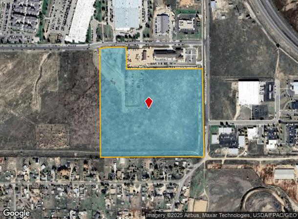
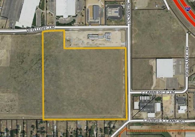
Adams St, Laramie, WY 82070

NEARBY LISTINGS FOR SALE OR LEASE
Property Detail
Adams St
05-1573-06-1-00-035.00
15 N 73 W 6 SENE TR IN. TOTAL AC: 32.522
Commercialacreage
Albany
X
Wyoming
56001C1765E
32.52 AC
2024
I-80 Corridor/Cheyenne
2025
Other Market Areas
962700
Laramie, WY
DEMOGRAPHICS near Adams St
1 Mile
3 Mile
5 Mile
2024 Total Population
2,879
25,739
34,633
2029 Population
3,046
26,771
36,213
Pop Growth 2024-2029
+ 5.80%
+ 4.01%
+ 4.56%
Average Age
36
34
34
2024 Total Households
1,208
11,250
14,866
HH Growth 2024-2029
+ 5.79%
+ 4.33%
+ 4.90%
Median Household Inc
$54,216
$43,068
$46,914
Avg Household Size
2.20
2.00
2.10
2024 Avg HH Vehicles
2.00
2.00
2.00
Median Home Value
$172,940
$236,920
$274,930
Median Year Built
1978
1973
1977
Nearby Places
Map Layers
Map Styles
 Street
 Aerial
- Restaurants
- Banks
- Shops
- Fitness
- Groceries
SALE & LEASE HISTORY
LISTING DATE
SALE/LEASE

Jun 01, 2017
For Sale
Nearby Properties
Address
Land Use
TOTAL SIZE
Lot Size
Zoning
Address
Land Use
TOTAL SIZE
Lot Size
Zoning
4,754 SF
41.54 AC
Address
Land Use
TOTAL SIZE
Lot Size
Zoning
1 SF
75.17 AC
Address
Land Use
TOTAL SIZE
Lot Size
Zoning
184,618 SF
0.62 AC
Address
Land Use
TOTAL SIZE
Lot Size
Zoning
129,760 SF
4.15 AC
Address
Land Use
TOTAL SIZE
Lot Size
Zoning
164,069 SF
9.62 AC
Address
Land Use
TOTAL SIZE
Lot Size
Zoning
167,415 SF
12.68 AC
Address
Land Use
TOTAL SIZE
Lot Size
Zoning
190,796 SF
11.18 AC
Address
Land Use
TOTAL SIZE
Lot Size
Zoning
131,020 SF
8.54 AC
Address
Land Use
TOTAL SIZE
Lot Size
Zoning
48,116 SF
5.63 AC
Address
Land Use
TOTAL SIZE
Lot Size
Zoning
24,164 SF
2.56 AC
Address
Land Use
TOTAL SIZE
Lot Size
Zoning
85,866 SF
35.47 AC
Address
Land Use
TOTAL SIZE
Lot Size
Zoning
57,539 SF
1.70 AC
Address
Land Use
TOTAL SIZE
Lot Size
Zoning
147,598 SF
10.25 AC
Address
Land Use
TOTAL SIZE
Lot Size
Zoning
57,916 SF
40.14 AC
Address
Land Use
TOTAL SIZE
Lot Size
Zoning
44,728 SF
2.50 AC
Address
Land Use
TOTAL SIZE
Lot Size
Zoning
333,540 SF
22.20 AC
Address
Land Use
TOTAL SIZE
Lot Size
Zoning
109,672 SF
3.13 AC
Address
Land Use
TOTAL SIZE
Lot Size
Zoning
2,401 SF
27.27 AC
Address
Land Use
TOTAL SIZE
Lot Size
Zoning
58,752 SF
1.35 AC
Address
Land Use
TOTAL SIZE
Lot Size
Zoning
64,632 SF
5.89 AC
Address
Land Use
TOTAL SIZE
Lot Size
Zoning
72,020 SF
2.89 AC
Address
Land Use
TOTAL SIZE
Lot Size
Zoning
41,961 SF
7.27 AC
Address
Land Use
TOTAL SIZE
Lot Size
Zoning
61,241 SF
3.99 AC
Address
Land Use
TOTAL SIZE
Lot Size
Zoning
51,466 SF
1.86 AC
Address
Land Use
TOTAL SIZE
Lot Size
Zoning
50,980 SF
1.26 AC
Address
Land Use
TOTAL SIZE
Lot Size
Zoning
21,332 SF
93 AC
Address
Land Use
TOTAL SIZE
Lot Size
Zoning
51,828 SF
1.60 AC
Address
Land Use
TOTAL SIZE
Lot Size
Zoning
45,192 SF
2.03 AC
Address
Land Use
TOTAL SIZE
Lot Size
Zoning
6,435 SF
21.58 AC
Address
Land Use
TOTAL SIZE
Lot Size
Zoning
45,889 SF
3.03 AC
The World's #1 Commercial Real Estate Marketplace
Connect with us
© 2025 CoStar Group
The information above has been obtained from sources believed reliable. While we do not doubt its accuracy we have not verified it and make no guarantee, warranty or representation about it. It is your responsibility to independently confirm its accuracy and completeness. Any projections, opinions, assumptions, or estimates used are for example only and do not represent the current or future performance of the property. The value of this transaction to you depends on tax and other factors which should be evaluated by your tax, financial, and legal advisors. You and your advisors should conduct a careful, independent investigation of the property to determine to your satisfaction the suitability of the property for your needs.