Property Record
Adamson Rd, Huntley, IL 60142
Property Detail
Adamson Rd
Chicago-Naperville-Elgin, IL-IN
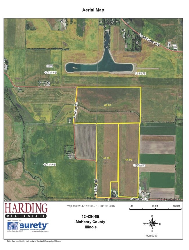
DOC 2021R0063439 PT SE1/4 SE1/4 LYING E OF CEN HWY & N OF CEN KISHWAUKEE RIVER
18-18-100-003
MCHENRY
Farms
Illinois
AE The base floodplain where base flood elevations are provided. AE Zones are now used on new format FIRMs instead of A1-A30 Zones.
83.76 AC
2024
Far Northwest
2024
Chicago
871501
NEARBY LISTINGS FOR SALE OR LEASE
-
-
View all Huntley listings for sale on LoopNet.com
DEMOGRAPHICS near Adamson Rd
1 mile
3 mile
5 mile
2025 Total Population
53
6,001
46,298
2030 Population
54
6,197
47,113
Pop Growth 2025-2030
+ 1.89%
+ 3.27%
+ 1.76%
Average Age
37
36
43
2025 Total Households
16
1,892
16,624
HH Growth 2025-2030
+ 6.25%
+ 3.33%
+ 1.86%
Median Household Inc
$124,999
$134,876
$109,493
Avg Household Size
3.20
3.10
2.70
2025 Avg HH Vehicles
2.00
2.00
2.00
Median Home Value
$421,428
$410,039
$351,550
Median Year Built
2010
2009
2002
Nearby Places
Map Layers
Map Styles
 Street
 Aerial
Layers
 Traffic
 Biking
Places
Listings with unknown addresses are not visible on the map
- Restaurants
- Banks
- Shops
- Fitness
- Groceries
SALE & LEASE HISTORY
LISTING DATE
SALE/LEASE

Nov 09, 2017
For Sale
Nearby Properties
Address
Land Use
TOTAL SIZE
Lot Size
Zoning
Address
Land Use
TOTAL SIZE
Lot Size
Zoning
8.23 AC
Address
Land Use
TOTAL SIZE
Lot Size
Zoning
85,500 SF
7 AC
Address
Land Use
TOTAL SIZE
Lot Size
Zoning
4,838 SF
12.62 AC
Address
Land Use
TOTAL SIZE
Lot Size
Zoning
21,429 SF
1.31 AC
Address
Land Use
TOTAL SIZE
Lot Size
Zoning
9.13 AC
Address
Land Use
TOTAL SIZE
Lot Size
Zoning
14,410 SF
1 AC
Address
Land Use
TOTAL SIZE
Lot Size
Zoning
14,781 SF
2.62 AC
Address
Land Use
TOTAL SIZE
Lot Size
Zoning
1.78 AC
Address
Land Use
TOTAL SIZE
Lot Size
Zoning
8,797 SF
2.46 AC
Address
Land Use
TOTAL SIZE
Lot Size
Zoning
1.83 AC
Address
Land Use
TOTAL SIZE
Lot Size
Zoning
11,936 SF
11.47 AC
Address
Land Use
TOTAL SIZE
Lot Size
Zoning
6,529 SF
0.49 AC
Address
Land Use
TOTAL SIZE
Lot Size
Zoning
2.65 AC
Address
Land Use
TOTAL SIZE
Lot Size
Zoning
4,295 SF
2 AC
Address
Land Use
TOTAL SIZE
Lot Size
Zoning
Address
Land Use
TOTAL SIZE
Lot Size
Zoning
3,482 SF
0.50 AC
Address
Land Use
TOTAL SIZE
Lot Size
Zoning
5,822 SF
0.49 AC
Address
Land Use
TOTAL SIZE
Lot Size
Zoning
4,304 SF
0.49 AC
Address
Land Use
TOTAL SIZE
Lot Size
Zoning
3,000 SF
2.46 AC
Address
Land Use
TOTAL SIZE
Lot Size
Zoning
6,434 SF
0.49 AC
Address
Land Use
TOTAL SIZE
Lot Size
Zoning
5,000 SF
0.49 AC
Address
Land Use
TOTAL SIZE
Lot Size
Zoning
3,404 SF
0.49 AC
Address
Land Use
TOTAL SIZE
Lot Size
Zoning
0.30 AC
Address
Land Use
TOTAL SIZE
Lot Size
Zoning
4,591 SF
0.53 AC
Address
Land Use
TOTAL SIZE
Lot Size
Zoning
1.38 AC
Address
Land Use
TOTAL SIZE
Lot Size
Zoning
1,950 SF
1.34 AC
Address
Land Use
TOTAL SIZE
Lot Size
Zoning
Address
Land Use
TOTAL SIZE
Lot Size
Zoning
Address
Land Use
TOTAL SIZE
Lot Size
Zoning
3,038 SF
5 AC
Address
Land Use
TOTAL SIZE
Lot Size
Zoning
14.02 AC
The World's #1 Commercial Real Estate Marketplace
Connect with us
© 2026 CoStar Group
The information above has been obtained from sources believed reliable. While we do not doubt its accuracy we have not verified it and make no guarantee, warranty or representation about it. It is your responsibility to independently confirm its accuracy and completeness. Any projections, opinions, assumptions, or estimates used are for example only and do not represent the current or future performance of the property. The value of this transaction to you depends on tax and other factors which should be evaluated by your tax, financial, and legal advisors. You and your advisors should conduct a careful, independent investigation of the property to determine to your satisfaction the suitability of the property for your needs.