Property Record
Address Unknown, Eugene, OR 97404
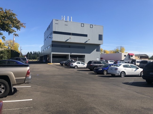


Property Detail
Address Unknown
Eugene-Springfield, OR
TL 01001
1424066
Lane
Commercialbuilding
Oregon
X
1001
41039C1107F
0.18 AC
2025
Lane County
2025
Portland
0010023028
NEARBY LISTINGS FOR SALE OR LEASE
DEMOGRAPHICS near Address Unknown
1 mile
3 mile
5 mile
2024 Total Population
13,400
74,881
160,068
2029 Population
13,295
74,902
160,381
Pop Growth 2024-2029
(0.78%)
+ 0.03%
+ 0.20%
Average Age
42
42
40
2024 Total Households
5,297
29,721
67,489
HH Growth 2024-2029
(0.94%)
(0.03%)
+ 0.21%
Median Household Inc
$69,052
$72,562
$58,909
Avg Household Size
2.50
2.30
2.20
2024 Avg HH Vehicles
2.00
2.00
2.00
Median Home Value
$343,977
$355,156
$360,811
Median Year Built
1969
1978
1978
Nearby Places
Map Layers
Map Styles
 Street
 Aerial
Transit
 Traffic
 Biking
Places
Listings with unknown addresses are not visible on the map
- Restaurants
- Banks
- Shops
- Fitness
- Groceries
PUBLIC TRANSPORTATION
COMMUTER RAIL
Eugene (Amtrak Cascades - Amtrak, Coast Starlight - Amtrak)
Drive
Walk
Distance
Eugene (Amtrak Cascades - Amtrak, Coast Starlight - Amtrak)
9 min
5.1 mi
AIRPORT
Mahlon Sweet Field
Drive
Walk
Distance
Mahlon Sweet Field
11 min
5.3 mi
Freight Ports
Port of Coos Bay, OR
Drive
Walk
Distance
Port of Coos Bay, OR
151 min
109.5 mi
SALE & LEASE HISTORY
LISTING DATE
SALE/LEASE

Sep 25, 2016
For Lease
Oct 17, 2019
For Sale
Nov 20, 2023
For Lease
Mar 16, 2021
For Lease
Jul 24, 2020
For Sale
Jan 04, 2018
For Lease
Apr 11, 2022
For Lease
Nearby Properties
Address
Land Use
TOTAL SIZE
Lot Size
Zoning
Address
Land Use
TOTAL SIZE
Lot Size
Zoning
Address
Land Use
TOTAL SIZE
Lot Size
Zoning
44.56 AC
PL
Address
Land Use
TOTAL SIZE
Lot Size
Zoning
12.42 AC
AG
Address
Land Use
TOTAL SIZE
Lot Size
Zoning
11.80 AC
PL
Address
Land Use
TOTAL SIZE
Lot Size
Zoning
480 SF
35.67 AC
AG
Address
Land Use
TOTAL SIZE
Lot Size
Zoning
26.13 AC
E30
Address
Land Use
TOTAL SIZE
Lot Size
Zoning
15.95 AC
Address
Land Use
TOTAL SIZE
Lot Size
Zoning
25.78 AC
C-2
Address
Land Use
TOTAL SIZE
Lot Size
Zoning
22.83 AC
PL
Address
Land Use
TOTAL SIZE
Lot Size
Zoning
Address
Land Use
TOTAL SIZE
Lot Size
Zoning
6.94 AC
PL
Address
Land Use
TOTAL SIZE
Lot Size
Zoning
8.69 AC
R-1
Address
Land Use
TOTAL SIZE
Lot Size
Zoning
12.53 AC
R-2
Address
Land Use
TOTAL SIZE
Lot Size
Zoning
4.67 AC
PL
Address
Land Use
TOTAL SIZE
Lot Size
Zoning
44.67 AC
I-2
Address
Land Use
TOTAL SIZE
Lot Size
Zoning
4.85 AC
PL
Address
Land Use
TOTAL SIZE
Lot Size
Zoning
14.20 AC
R-1
Address
Land Use
TOTAL SIZE
Lot Size
Zoning
3,634 SF
6.34 AC
R-2
Address
Land Use
TOTAL SIZE
Lot Size
Zoning
5.38 AC
PL
Address
Land Use
TOTAL SIZE
Lot Size
Zoning
12.36 AC
C-1
Address
Land Use
TOTAL SIZE
Lot Size
Zoning
5.98 AC
PL
Address
Land Use
TOTAL SIZE
Lot Size
Zoning
7.38 AC
C-2
Address
Land Use
TOTAL SIZE
Lot Size
Zoning
0.97 AC
PL
Address
Land Use
TOTAL SIZE
Lot Size
Zoning
6.94 AC
R-1
Address
Land Use
TOTAL SIZE
Lot Size
Zoning
6.67 AC
PL
Address
Land Use
TOTAL SIZE
Lot Size
Zoning
16.81 AC
SG
Address
Land Use
TOTAL SIZE
Lot Size
Zoning
12.37 AC
R-1
Address
Land Use
TOTAL SIZE
Lot Size
Zoning
3.53 AC
PL
Address
Land Use
TOTAL SIZE
Lot Size
Zoning
37.58 AC
PL
Address
Land Use
TOTAL SIZE
Lot Size
Zoning
21.88 AC
PL
The World's #1 Commercial Real Estate Marketplace
Connect with us
© 2026 CoStar Group
The information above has been obtained from sources believed reliable. While we do not doubt its accuracy we have not verified it and make no guarantee, warranty or representation about it. It is your responsibility to independently confirm its accuracy and completeness. Any projections, opinions, assumptions, or estimates used are for example only and do not represent the current or future performance of the property. The value of this transaction to you depends on tax and other factors which should be evaluated by your tax, financial, and legal advisors. You and your advisors should conduct a careful, independent investigation of the property to determine to your satisfaction the suitability of the property for your needs.