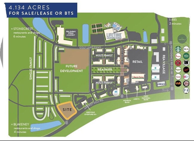
Property Record
11420 Red Rust Ln, Charlotte, NC 28277

Property Detail
11420 Red Rust Ln
229-171-39
L2 M60-325 THRU 329
Commercialnec
MECKLENBURG
MUDD-O
North Carolina
B and X Area of moderate flood hazard, usually the area between the limits of the 100-year and 500-year floods.
2
2024
4.13 AC
2025
South/485
005859
Charlotte
31,806 SF
Charlotte-Concord-Gastonia, NC-SC
NEARBY LISTINGS FOR SALE OR LEASE
DEMOGRAPHICS near 11420 Red Rust Ln
1 mile
3 mile
5 mile
2025 Total Population
10,692
62,566
175,457
2030 Population
11,629
67,211
188,726
Pop Growth 2025-2030
+ 8.76%
+ 7.42%
+ 7.56%
Average Age
38
40
40
2025 Total Households
4,054
23,205
64,622
HH Growth 2025-2030
+ 9.15%
+ 7.61%
+ 7.70%
Median Household Inc
$149,699
$148,822
$136,100
Avg Household Size
2.60
2.70
2.70
2025 Avg HH Vehicles
2.00
2.00
2.00
Median Home Value
$697,874
$687,531
$678,878
Median Year Built
2010
1999
1999
Nearby Places
Map Layers
Map Styles
 Street
 Aerial
Layers
 Traffic
 Biking
Places
Listings with unknown addresses are not visible on the map
- Restaurants
- Banks
- Shops
- Fitness
- Groceries
PUBLIC TRANSPORTATION
AIRPORT
Charlotte/Douglas International
Drive
Walk
Distance
Charlotte/Douglas International
30 min
19.3 mi
Concord-Padgett Regional
Drive
Walk
Distance
Concord-Padgett Regional
40 min
31.7 mi
SALE & LEASE HISTORY
LISTING DATE
SALE/LEASE

Feb 14, 2018
For Sale
Nearby Properties
Address
Land Use
TOTAL SIZE
Lot Size
Zoning
Address
Land Use
TOTAL SIZE
Lot Size
Zoning
476,565 SF
13.18 AC
Address
Land Use
TOTAL SIZE
Lot Size
Zoning
339,072 SF
20.65 AC
B1SCD
Address
Land Use
TOTAL SIZE
Lot Size
Zoning
295,548 SF
43.48 AC
CC
Address
Land Use
TOTAL SIZE
Lot Size
Zoning
343,125 SF
24.48 AC
R12MFCD
Address
Land Use
TOTAL SIZE
Lot Size
Zoning
324,188 SF
51.13 AC
Address
Land Use
TOTAL SIZE
Lot Size
Zoning
291,482 SF
23.12 AC
R12MFCD
Address
Land Use
TOTAL SIZE
Lot Size
Zoning
261,874 SF
7.18 AC
Address
Land Use
TOTAL SIZE
Lot Size
Zoning
28.27 AC
Address
Land Use
TOTAL SIZE
Lot Size
Zoning
248,806 SF
6.12 AC
Address
Land Use
TOTAL SIZE
Lot Size
Zoning
353,996 SF
58.49 AC
R3
Address
Land Use
TOTAL SIZE
Lot Size
Zoning
257,686 SF
26.78 AC
R8MFCD
Address
Land Use
TOTAL SIZE
Lot Size
Zoning
296,002 SF
3 AC
Address
Land Use
TOTAL SIZE
Lot Size
Zoning
315,524 SF
3.84 AC
Address
Land Use
TOTAL SIZE
Lot Size
Zoning
234,773 SF
12.96 AC
Address
Land Use
TOTAL SIZE
Lot Size
Zoning
201,638 SF
7.44 AC
R-12PUD
Address
Land Use
TOTAL SIZE
Lot Size
Zoning
222,310 SF
3.51 AC
Address
Land Use
TOTAL SIZE
Lot Size
Zoning
117,672 SF
16.68 AC
CC
Address
Land Use
TOTAL SIZE
Lot Size
Zoning
192,527 SF
24.08 AC
Address
Land Use
TOTAL SIZE
Lot Size
Zoning
154,021 SF
15.08 AC
Address
Land Use
TOTAL SIZE
Lot Size
Zoning
121,464 SF
13.35 AC
Address
Land Use
TOTAL SIZE
Lot Size
Zoning
185,302 SF
47.89 AC
R3
Address
Land Use
TOTAL SIZE
Lot Size
Zoning
159,801 SF
17.02 AC
CC
Address
Land Use
TOTAL SIZE
Lot Size
Zoning
7.54 AC
Address
Land Use
TOTAL SIZE
Lot Size
Zoning
132,576 SF
3.54 AC
Address
Land Use
TOTAL SIZE
Lot Size
Zoning
214,445 SF
15.80 AC
R15MFCD
Address
Land Use
TOTAL SIZE
Lot Size
Zoning
160,395 SF
34.25 AC
R3
Address
Land Use
TOTAL SIZE
Lot Size
Zoning
134,936 SF
10 AC
MX-1(INNOV
Address
Land Use
TOTAL SIZE
Lot Size
Zoning
182,894 SF
14.51 AC
R15MFCD
Address
Land Use
TOTAL SIZE
Lot Size
Zoning
84,475 SF
15.19 AC
CC
Address
Land Use
TOTAL SIZE
Lot Size
Zoning
121,812 SF
13.92 AC
CC
The World's #1 Commercial Real Estate Marketplace
Connect with us
© 2026 CoStar Group
The information above has been obtained from sources believed reliable. While we do not doubt its accuracy we have not verified it and make no guarantee, warranty or representation about it. It is your responsibility to independently confirm its accuracy and completeness. Any projections, opinions, assumptions, or estimates used are for example only and do not represent the current or future performance of the property. The value of this transaction to you depends on tax and other factors which should be evaluated by your tax, financial, and legal advisors. You and your advisors should conduct a careful, independent investigation of the property to determine to your satisfaction the suitability of the property for your needs.