Property Record
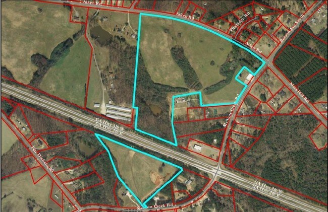
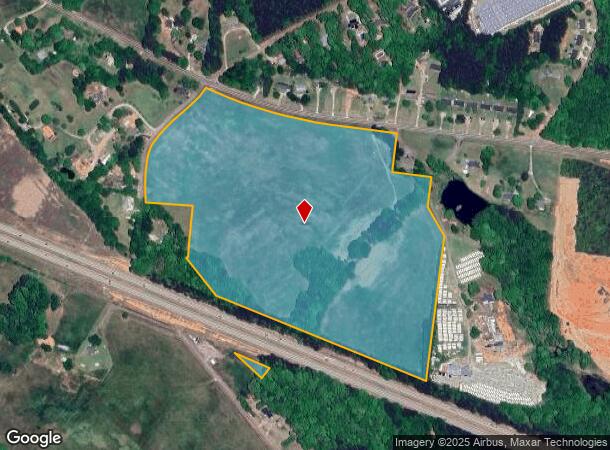
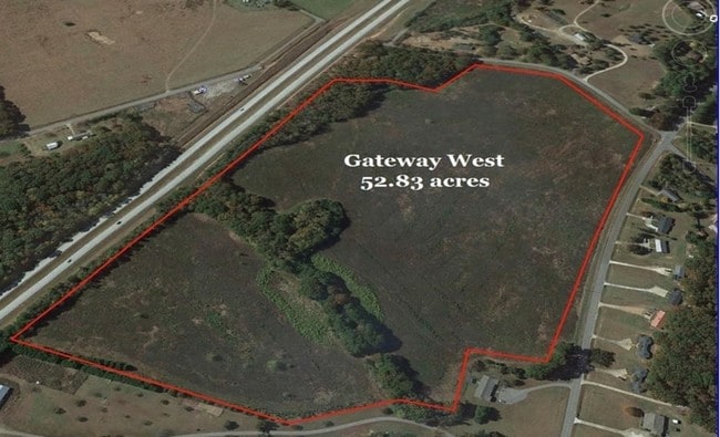
Aiken Rd, Bogart, GA 30622
NEARBY LISTINGS FOR SALE OR LEASE
Property Detail
Aiken Rd
Athens-Clarke County, GA
Exempt Development Authority
B01-0-72
496/225 32/ 7
Governmentalpublicusegeneral
Oconee
X
Georgia
13013C0175D
52.83 AC
2025
Athens/Gainesville
2024
Other Market Areas
030103
DEMOGRAPHICS near Aiken Rd
1 Mile
3 Mile
5 Mile
2024 Total Population
1,280
12,776
33,060
2029 Population
1,435
14,424
37,200
Pop Growth 2024-2029
+ 12.11%
+ 12.90%
+ 12.52%
Average Age
37
38
39
2024 Total Households
446
4,512
11,967
HH Growth 2024-2029
+ 12.33%
+ 12.81%
+ 12.07%
Median Household Inc
$90,561
$87,444
$81,709
Avg Household Size
2.90
2.80
2.70
2024 Avg HH Vehicles
2.00
2.00
2.00
Median Home Value
$282,777
$286,621
$299,855
Median Year Built
1996
2003
2001
Nearby Places
- Restaurants
- Banks
- Shops
- Fitness
- Groceries
SALE & LEASE HISTORY
LISTING DATE
SALE/LEASE

Sep 24, 2016
For Sale
Nearby Properties
Address
Land Use
TOTAL SIZE
Lot Size
Zoning
Address
Land Use
TOTAL SIZE
Lot Size
Zoning
93,677 SF
74.41 AC
AG
Address
Land Use
TOTAL SIZE
Lot Size
Zoning
1 SF
126.93 AC
E-I
Address
Land Use
TOTAL SIZE
Lot Size
Zoning
160,000 SF
29.40 AC
O-I
Address
Land Use
TOTAL SIZE
Lot Size
Zoning
425,000 SF
45.22 AC
I
Address
Land Use
TOTAL SIZE
Lot Size
Zoning
30,056 SF
311.70 AC
R-2
Address
Land Use
TOTAL SIZE
Lot Size
Zoning
4,500 SF
6.06 AC
C-G
Address
Land Use
TOTAL SIZE
Lot Size
Zoning
2,979 SF
203.51 AC
I
Address
Land Use
TOTAL SIZE
Lot Size
Zoning
11,060 SF
5.42 AC
Address
Land Use
TOTAL SIZE
Lot Size
Zoning
99,600 SF
10.12 AC
001
Address
Land Use
TOTAL SIZE
Lot Size
Zoning
33,704 SF
14.20 AC
O-I
Address
Land Use
TOTAL SIZE
Lot Size
Zoning
11,130 SF
32.08 AC
B-2
Address
Land Use
TOTAL SIZE
Lot Size
Zoning
147.09 AC
E-I
Address
Land Use
TOTAL SIZE
Lot Size
Zoning
Address
Land Use
TOTAL SIZE
Lot Size
Zoning
36,000 SF
0.80 AC
Address
Land Use
TOTAL SIZE
Lot Size
Zoning
36.07 AC
B-2
Address
Land Use
TOTAL SIZE
Lot Size
Zoning
6,191 SF
2.37 AC
B-2
Address
Land Use
TOTAL SIZE
Lot Size
Zoning
25,044 SF
9.20 AC
M-1
Address
Land Use
TOTAL SIZE
Lot Size
Zoning
18,232 SF
34.79 AC
AG
Address
Land Use
TOTAL SIZE
Lot Size
Zoning
199.34 AC
AG
Address
Land Use
TOTAL SIZE
Lot Size
Zoning
152.78 AC
AR
Address
Land Use
TOTAL SIZE
Lot Size
Zoning
16,870 SF
4.17 AC
C-G
Address
Land Use
TOTAL SIZE
Lot Size
Zoning
6,600 SF
4.32 AC
B-2
Address
Land Use
TOTAL SIZE
Lot Size
Zoning
37,005 SF
4.01 AC
C-G
Address
Land Use
TOTAL SIZE
Lot Size
Zoning
11,440 SF
4.03 AC
B-2
Address
Land Use
TOTAL SIZE
Lot Size
Zoning
60.25 AC
E-I
Address
Land Use
TOTAL SIZE
Lot Size
Zoning
75.46 AC
B-2
Address
Land Use
TOTAL SIZE
Lot Size
Zoning
9,165 SF
1.61 AC
B-2
Address
Land Use
TOTAL SIZE
Lot Size
Zoning
77.70 AC
OBP
Address
Land Use
TOTAL SIZE
Lot Size
Zoning
104.60 AC
003
Address
Land Use
TOTAL SIZE
Lot Size
Zoning
3,619 SF
4.90 AC
001
The World's #1 Commercial Real Estate Marketplace
Connect with us
© 2025 CoStar Group
The information above has been obtained from sources believed reliable. While we do not doubt its accuracy we have not verified it and make no guarantee, warranty or representation about it. It is your responsibility to independently confirm its accuracy and completeness. Any projections, opinions, assumptions, or estimates used are for example only and do not represent the current or future performance of the property. The value of this transaction to you depends on tax and other factors which should be evaluated by your tax, financial, and legal advisors. You and your advisors should conduct a careful, independent investigation of the property to determine to your satisfaction the suitability of the property for your needs.