No Photo
Property Record
Airport Rd, Georgetown, TX 78628

Save to a Folder
{{folder.Name}}
{{folder.ListingIds.length}} Properties
{{folder.ListingIds.length}} Property
Create a New Folder
Property Detail
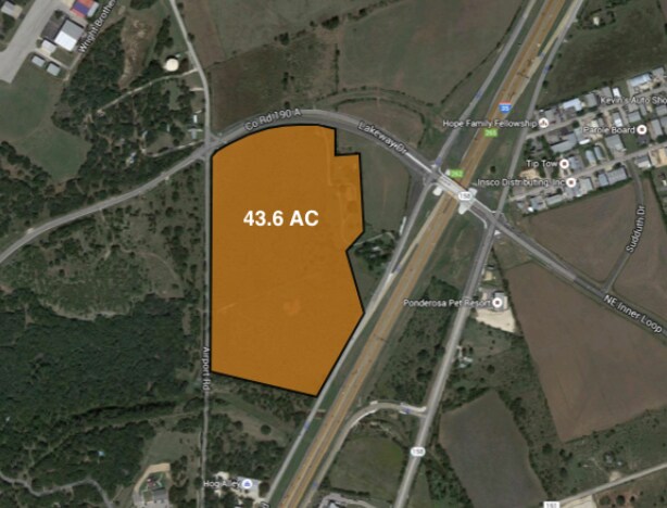
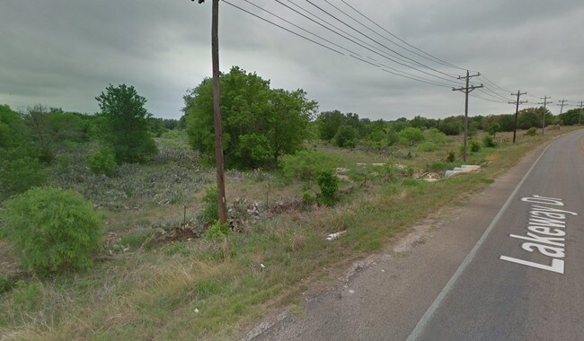
Airport Rd
Austin-Round Rock-San Marcos, TX
AW0013 AW0013 - WRIGHT, D. SUR., ACRES 23.232
R038684
WILLIAMSON
Agriculturalland
Texas
AE The base floodplain where base flood elevations are provided. AE Zones are now used on new format FIRMs instead of A1-A30 Zones.
23.23 AC
2024
Georgetown
2025
Austin
020121
NEARBY LISTINGS FOR SALE OR LEASE
DEMOGRAPHICS near Airport Rd
1 mile
3 mile
5 mile
2025 Total Population
3,239
41,379
87,902
2030 Population
3,756
47,714
101,528
Pop Growth 2025-2030
+ 15.96%
+ 15.31%
+ 15.50%
Average Age
38
42
44
2025 Total Households
1,230
16,444
36,228
HH Growth 2025-2030
+ 16.67%
+ 15.90%
+ 15.90%
Median Household Inc
$70,570
$96,476
$97,684
Avg Household Size
2.60
2.40
2.30
2025 Avg HH Vehicles
2.00
2.00
2.00
Median Home Value
$330,465
$453,772
$451,497
Median Year Built
1997
2004
2005
Nearby Places
Map Layers
Map Styles
 Street
 Aerial
Layers
 Traffic
 Biking
Places
Listings with unknown addresses are not visible on the map
- Restaurants
- Banks
- Shops
- Fitness
- Groceries
PUBLIC TRANSPORTATION
AIRPORT
Killeen Municipal
Drive
Walk
Distance
Killeen Municipal
50 min
39.2 mi
Robert Gray AAF
Drive
Walk
Distance
Robert Gray AAF
54 min
40.0 mi
Freight Ports
Calhoun Port
Drive
Walk
Distance
Calhoun Port
212 min
186.7 mi
SALE & LEASE HISTORY
LISTING DATE
SALE/LEASE

Feb 20, 2018
For Sale
Nearby Properties
Address
Land Use
TOTAL SIZE
Lot Size
Zoning
Address
Land Use
TOTAL SIZE
Lot Size
Zoning
71.65 AC
1-RS
Address
Land Use
TOTAL SIZE
Lot Size
Zoning
389,888 SF
30 AC
1-MF
Address
Land Use
TOTAL SIZE
Lot Size
Zoning
200,200 SF
34.02 AC
Address
Land Use
TOTAL SIZE
Lot Size
Zoning
453,015 SF
22.62 AC
Address
Land Use
TOTAL SIZE
Lot Size
Zoning
495,688 SF
20.31 AC
1-MF
Address
Land Use
TOTAL SIZE
Lot Size
Zoning
326,646 SF
19.33 AC
Address
Land Use
TOTAL SIZE
Lot Size
Zoning
425,144 SF
32.97 AC
Address
Land Use
TOTAL SIZE
Lot Size
Zoning
439,044 SF
32.68 AC
Address
Land Use
TOTAL SIZE
Lot Size
Zoning
233,173 SF
9.89 AC
Address
Land Use
TOTAL SIZE
Lot Size
Zoning
282,472 SF
11.79 AC
Address
Land Use
TOTAL SIZE
Lot Size
Zoning
294,214 SF
18.34 AC
Address
Land Use
TOTAL SIZE
Lot Size
Zoning
252,492 SF
15.35 AC
Address
Land Use
TOTAL SIZE
Lot Size
Zoning
316,931 SF
3.02 AC
Address
Land Use
TOTAL SIZE
Lot Size
Zoning
520,121 SF
56.73 AC
Address
Land Use
TOTAL SIZE
Lot Size
Zoning
241,804 SF
17.57 AC
3-C-3
Address
Land Use
TOTAL SIZE
Lot Size
Zoning
120,653 SF
12.83 AC
Address
Land Use
TOTAL SIZE
Lot Size
Zoning
8,727 SF
89.67 AC
Address
Land Use
TOTAL SIZE
Lot Size
Zoning
193,985 SF
38.17 AC
Address
Land Use
TOTAL SIZE
Lot Size
Zoning
186,337 SF
8.39 AC
Address
Land Use
TOTAL SIZE
Lot Size
Zoning
298,302 SF
20.96 AC
Address
Land Use
TOTAL SIZE
Lot Size
Zoning
610,222 SF
10.16 AC
Address
Land Use
TOTAL SIZE
Lot Size
Zoning
176,875 SF
14.75 AC
3-C-1
Address
Land Use
TOTAL SIZE
Lot Size
Zoning
241,857 SF
26.60 AC
Address
Land Use
TOTAL SIZE
Lot Size
Zoning
200,746 SF
17.52 AC
Address
Land Use
TOTAL SIZE
Lot Size
Zoning
232,368 SF
16.40 AC
Address
Land Use
TOTAL SIZE
Lot Size
Zoning
155,674 SF
10.96 AC
Address
Land Use
TOTAL SIZE
Lot Size
Zoning
592 SF
42.32 AC
Address
Land Use
TOTAL SIZE
Lot Size
Zoning
154,603 SF
20.04 AC
Address
Land Use
TOTAL SIZE
Lot Size
Zoning
121,117 SF
12.04 AC
Address
Land Use
TOTAL SIZE
Lot Size
Zoning
172,657 SF
8.84 AC
The World's #1 Commercial Real Estate Marketplace
Connect with us
© 2026 CoStar Group
The information above has been obtained from sources believed reliable. While we do not doubt its accuracy we have not verified it and make no guarantee, warranty or representation about it. It is your responsibility to independently confirm its accuracy and completeness. Any projections, opinions, assumptions, or estimates used are for example only and do not represent the current or future performance of the property. The value of this transaction to you depends on tax and other factors which should be evaluated by your tax, financial, and legal advisors. You and your advisors should conduct a careful, independent investigation of the property to determine to your satisfaction the suitability of the property for your needs.