Property Record
Airport Rd, Maxton, NC 28364
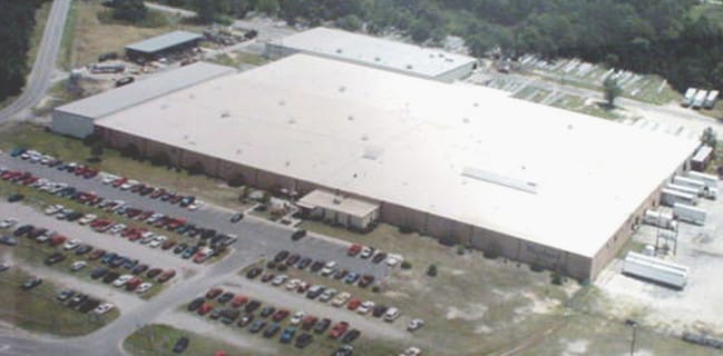

Property Detail
Airport Rd
01-0250-01-025
LBG. MAXTON AIR BASE
Industrialgeneral
SCOTLAND
I
North Carolina
B and X Area of moderate flood hazard, usually the area between the limits of the 100-year and 500-year floods.
26.20 AC
2025
North Carolina Southeast Area
2025
Other Market Areas
962001
Laurinburg, NC
101,838 SF
NEARBY LISTINGS FOR SALE OR LEASE
-
-
View all Maxton listings for sale on LoopNet.com
DEMOGRAPHICS near Airport Rd
1 mile
3 mile
5 mile
2025 Total Population
220
5,171
13,234
2030 Population
216
5,291
13,561
Pop Growth 2025-2030
(1.82%)
+ 2.32%
+ 2.47%
Average Age
45
40
40
2025 Total Households
20
1,410
4,326
HH Growth 2025-2030
0.00%
+ 4.54%
+ 3.37%
Median Household Inc
$58,333
$28,543
$30,495
Avg Household Size
2.60
2.50
2.50
2025 Avg HH Vehicles
2.00
2.00
2.00
Median Home Value
$125,000
$74,687
$72,253
Median Year Built
1984
1981
1978
Nearby Places
Map Layers
Map Styles
 Street
 Aerial
Layers
 Traffic
 Biking
Places
Listings with unknown addresses are not visible on the map
- Restaurants
- Banks
- Shops
- Fitness
- Groceries
Nearby Properties
Address
Land Use
TOTAL SIZE
Lot Size
Zoning
Address
Land Use
TOTAL SIZE
Lot Size
Zoning
208,125 SF
338.14 AC
I2
Address
Land Use
TOTAL SIZE
Lot Size
Zoning
5,000 SF
3,161.45 AC
I2
Address
Land Use
TOTAL SIZE
Lot Size
Zoning
22,140 SF
10.66 AC
I
Address
Land Use
TOTAL SIZE
Lot Size
Zoning
11,010 SF
424 AC
I2
Address
Land Use
TOTAL SIZE
Lot Size
Zoning
175,000 SF
23.21 AC
I1
Address
Land Use
TOTAL SIZE
Lot Size
Zoning
20,160 SF
32.90 AC
RA
Address
Land Use
TOTAL SIZE
Lot Size
Zoning
17.50 AC
R12
Address
Land Use
TOTAL SIZE
Lot Size
Zoning
205,700 SF
13.89 AC
I
Address
Land Use
TOTAL SIZE
Lot Size
Zoning
7,548 SF
93.10 AC
I2
Address
Land Use
TOTAL SIZE
Lot Size
Zoning
30,860 SF
57.89 AC
I2
Address
Land Use
TOTAL SIZE
Lot Size
Zoning
11,824 SF
59.60 AC
I
Address
Land Use
TOTAL SIZE
Lot Size
Zoning
4,632 SF
24.89 AC
I1
Address
Land Use
TOTAL SIZE
Lot Size
Zoning
4,272 SF
8.09 AC
RA
Address
Land Use
TOTAL SIZE
Lot Size
Zoning
153,440 SF
12 AC
I
Address
Land Use
TOTAL SIZE
Lot Size
Zoning
33,318 SF
9.03 AC
R10
Address
Land Use
TOTAL SIZE
Lot Size
Zoning
44,000 SF
10 AC
I2
Address
Land Use
TOTAL SIZE
Lot Size
Zoning
50,120 SF
31.30 AC
RA
Address
Land Use
TOTAL SIZE
Lot Size
Zoning
6,543 SF
2.12 AC
RA
Address
Land Use
TOTAL SIZE
Lot Size
Zoning
28,090 SF
3.96 AC
HB
Address
Land Use
TOTAL SIZE
Lot Size
Zoning
2,109 SF
1.65 AC
R10
Address
Land Use
TOTAL SIZE
Lot Size
Zoning
111,312 SF
23.70 AC
I
Address
Land Use
TOTAL SIZE
Lot Size
Zoning
24,808 SF
3.87 AC
R12
Address
Land Use
TOTAL SIZE
Lot Size
Zoning
11,424 SF
1.65 AC
NB
Address
Land Use
TOTAL SIZE
Lot Size
Zoning
2,500 SF
10.27 AC
R10
Address
Land Use
TOTAL SIZE
Lot Size
Zoning
458.79 AC
RA
Address
Land Use
TOTAL SIZE
Lot Size
Zoning
4,868 SF
56.07 AC
RA
Address
Land Use
TOTAL SIZE
Lot Size
Zoning
1,372 SF
68.50 AC
I2
Address
Land Use
TOTAL SIZE
Lot Size
Zoning
10,342 SF
2.05 AC
RSFD
Address
Land Use
TOTAL SIZE
Lot Size
Zoning
3,512 SF
3.50 AC
R12
The World's #1 Commercial Real Estate Marketplace
Connect with us
© 2026 CoStar Group
The information above has been obtained from sources believed reliable. While we do not doubt its accuracy we have not verified it and make no guarantee, warranty or representation about it. It is your responsibility to independently confirm its accuracy and completeness. Any projections, opinions, assumptions, or estimates used are for example only and do not represent the current or future performance of the property. The value of this transaction to you depends on tax and other factors which should be evaluated by your tax, financial, and legal advisors. You and your advisors should conduct a careful, independent investigation of the property to determine to your satisfaction the suitability of the property for your needs.