Property Record
Airport Rd, Opelika, AL 36801
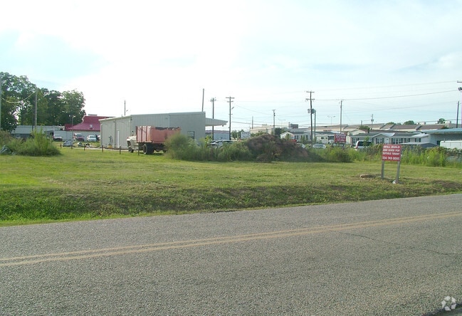

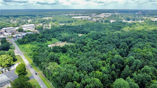
This Property Is For Sale
NEARBY LISTINGS FOR SALE OR LEASE
Property Detail
Airport Rd
09-05-15-4-000-055.001
BEG INT E R/W AIRPORT RD & S LINE SE1/4; TH E 1404'S NWLY 950'S; NE 335'S; SW 50'S; N 225'S; SW 770'S; SLY 75'S; WLY 385'S; S
Vacantlandnec
Lee
AE
Alabama
01081C0068H
37 AC
2025
Lee County
2025
Columbus GA
041300
Auburn-Opelika, AL
DEMOGRAPHICS near Airport Rd
1 Mile
3 Mile
5 Mile
2024 Total Population
4,521
34,496
84,793
2029 Population
4,948
37,512
92,298
Pop Growth 2024-2029
+ 9.44%
+ 8.74%
+ 8.85%
Average Age
39
38
36
2024 Total Households
1,824
14,414
33,898
HH Growth 2024-2029
+ 9.48%
+ 8.63%
+ 9.02%
Median Household Inc
$40,305
$47,318
$50,108
Avg Household Size
2.30
2.30
2.30
2024 Avg HH Vehicles
1.00
2.00
2.00
Median Home Value
$181,367
$212,746
$253,198
Median Year Built
2001
1994
1994
Nearby Places
Map Layers
Map Styles
 Street
 Aerial
- Restaurants
- Banks
- Shops
- Fitness
- Groceries
PUBLIC TRANSPORTATION
AIRPORT
Columbus
DRIVE
WALK
Distance
Columbus
50 min
36.3 mi
Freight Ports
Port of Panama City
DRIVE
WALK
Distance
Port of Panama City
265 min
201.1 mi
Nearby Properties
Address
Land Use
TOTAL SIZE
Lot Size
Zoning
Address
Land Use
TOTAL SIZE
Lot Size
Zoning
143,367 SF
5.90 AC
Address
Land Use
TOTAL SIZE
Lot Size
Zoning
133,954 SF
12.28 AC
Address
Land Use
TOTAL SIZE
Lot Size
Zoning
12,040 SF
23.60 AC
Address
Land Use
TOTAL SIZE
Lot Size
Zoning
13,615 SF
34.30 AC
Address
Land Use
TOTAL SIZE
Lot Size
Zoning
15,876 SF
30.47 AC
Address
Land Use
TOTAL SIZE
Lot Size
Zoning
4,840 SF
12.80 AC
Address
Land Use
TOTAL SIZE
Lot Size
Zoning
18,540 SF
12.99 AC
Address
Land Use
TOTAL SIZE
Lot Size
Zoning
11,076 SF
15.79 AC
Address
Land Use
TOTAL SIZE
Lot Size
Zoning
7,700 SF
13.75 AC
Address
Land Use
TOTAL SIZE
Lot Size
Zoning
181,866 SF
13.32 AC
Address
Land Use
TOTAL SIZE
Lot Size
Zoning
29,064 SF
10.10 AC
Address
Land Use
TOTAL SIZE
Lot Size
Zoning
484 SF
21.50 AC
Address
Land Use
TOTAL SIZE
Lot Size
Zoning
174,021 SF
29 AC
Address
Land Use
TOTAL SIZE
Lot Size
Zoning
218,643 SF
10.70 AC
Address
Land Use
TOTAL SIZE
Lot Size
Zoning
3,134 SF
5.23 AC
Address
Land Use
TOTAL SIZE
Lot Size
Zoning
1,471 SF
12.86 AC
Address
Land Use
TOTAL SIZE
Lot Size
Zoning
7,716 SF
26.36 AC
Address
Land Use
TOTAL SIZE
Lot Size
Zoning
48,493 SF
2.09 AC
Address
Land Use
TOTAL SIZE
Lot Size
Zoning
35,070 SF
5 AC
Address
Land Use
TOTAL SIZE
Lot Size
Zoning
467,323 SF
22.24 AC
Address
Land Use
TOTAL SIZE
Lot Size
Zoning
134,879 SF
18.10 AC
Address
Land Use
TOTAL SIZE
Lot Size
Zoning
8,440 SF
6.45 AC
Address
Land Use
TOTAL SIZE
Lot Size
Zoning
56,237 SF
9.68 AC
Address
Land Use
TOTAL SIZE
Lot Size
Zoning
124,101 SF
10.48 AC
Address
Land Use
TOTAL SIZE
Lot Size
Zoning
6.76 AC
Address
Land Use
TOTAL SIZE
Lot Size
Zoning
132,177 SF
16.44 AC
Address
Land Use
TOTAL SIZE
Lot Size
Zoning
2,247 SF
18 AC
Address
Land Use
TOTAL SIZE
Lot Size
Zoning
31,125 SF
3.40 AC
Address
Land Use
TOTAL SIZE
Lot Size
Zoning
71,705 SF
9.44 AC
Address
Land Use
TOTAL SIZE
Lot Size
Zoning
17,910 SF
3.44 AC
The World's #1 Commercial Real Estate Marketplace
Connect with us
© 2026 CoStar Group
The information above has been obtained from sources believed reliable. While we do not doubt its accuracy we have not verified it and make no guarantee, warranty or representation about it. It is your responsibility to independently confirm its accuracy and completeness. Any projections, opinions, assumptions, or estimates used are for example only and do not represent the current or future performance of the property. The value of this transaction to you depends on tax and other factors which should be evaluated by your tax, financial, and legal advisors. You and your advisors should conduct a careful, independent investigation of the property to determine to your satisfaction the suitability of the property for your needs.