Property Record
330 Akolea Rd, Hilo, HI 96720

NEARBY LISTINGS FOR SALE OR LEASE
-
-
View all Hilo listings for sale on LoopNet.com
Property Detail
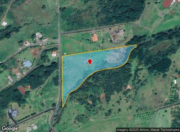
330 Akolea Rd
Hilo, HI
Ponahawai
3-2-5-006-162-0000
LOT 17-A 6.229 AC DES POR LPGR 5057 PONAHAWAI HMSTDS SUBJ/ESMTS
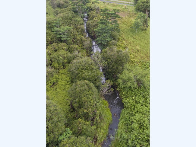
Agriculturalland
Hawaii
AE
Hawaii
1551660885F
17-a
2024
6.23 AC
2025
Hilo/East Big Island
020802
Hawaii
DEMOGRAPHICS near 330 Akolea Rd
1 Mile
3 Mile
5 Mile
2024 Total Population
2,026
17,628
48,249
2029 Population
2,096
18,799
51,967
Pop Growth 2024-2029
+ 3.46%
+ 6.64%
+ 7.71%
Average Age
40
44
42
2024 Total Households
684
6,166
17,545
HH Growth 2024-2029
+ 2.92%
+ 6.37%
+ 7.63%
Median Household Inc
$93,749
$92,269
$72,049
Avg Household Size
2.90
2.70
2.60
2024 Avg HH Vehicles
2.00
2.00
2.00
Median Home Value
$493,965
$513,901
$476,006
Median Year Built
1988
1983
1981
Nearby Places
Map Layers
Map Styles
 Street
 Aerial
- Restaurants
- Banks
- Shops
- Fitness
- Groceries
PUBLIC TRANSPORTATION
AIRPORT
Hilo International
DRIVE
WALK
Distance
Hilo International
28 min
11.8 mi
SALE & LEASE HISTORY
LISTING DATE
SALE/LEASE

Mar 21, 2018
For Sale
Nearby Properties
Address
Land Use
TOTAL SIZE
Lot Size
Zoning
Address
Land Use
TOTAL SIZE
Lot Size
Zoning
231,016 SF
20.40 AC
RS-10
Address
Land Use
TOTAL SIZE
Lot Size
Zoning
5.39 AC
RM-3
Address
Land Use
TOTAL SIZE
Lot Size
Zoning
38,412 SF
6.38 AC
RM-4
Address
Land Use
TOTAL SIZE
Lot Size
Zoning
53,338 SF
30 AC
A-1a
Address
Land Use
TOTAL SIZE
Lot Size
Zoning
51,762 SF
9.17 AC
RS-10
Address
Land Use
TOTAL SIZE
Lot Size
Zoning
71,912 SF
3 AC
A-3a
Address
Land Use
TOTAL SIZE
Lot Size
Zoning
23,434 SF
18.59 AC
A-1a
Address
Land Use
TOTAL SIZE
Lot Size
Zoning
1,837.33 AC
OPEN
Address
Land Use
TOTAL SIZE
Lot Size
Zoning
26,708 SF
2.05 AC
RS-10
Address
Land Use
TOTAL SIZE
Lot Size
Zoning
17,462 SF
0.76 AC
RS-10
Address
Land Use
TOTAL SIZE
Lot Size
Zoning
29,471 SF
1.42 AC
RM-3
Address
Land Use
TOTAL SIZE
Lot Size
Zoning
9,971 SF
1.59 AC
RM-3
Address
Land Use
TOTAL SIZE
Lot Size
Zoning
6,860 SF
0.73 AC
CN-10
Address
Land Use
TOTAL SIZE
Lot Size
Zoning
1.02 AC
CN-20
Address
Land Use
TOTAL SIZE
Lot Size
Zoning
22,302 SF
0.46 AC
CN-10
Address
Land Use
TOTAL SIZE
Lot Size
Zoning
7,621 SF
1.36 AC
CN-10
Address
Land Use
TOTAL SIZE
Lot Size
Zoning
9,082 SF
0.23 AC
CN-10
Address
Land Use
TOTAL SIZE
Lot Size
Zoning
7,375 SF
21.90 AC
A-20a
Address
Land Use
TOTAL SIZE
Lot Size
Zoning
9,568 SF
0.54 AC
CN-10
Address
Land Use
TOTAL SIZE
Lot Size
Zoning
1.28 AC
RM-5.5
Address
Land Use
TOTAL SIZE
Lot Size
Zoning
4,211 SF
0.69 AC
CN-10
Address
Land Use
TOTAL SIZE
Lot Size
Zoning
4,530 SF
5.05 AC
A-5a
Address
Land Use
TOTAL SIZE
Lot Size
Zoning
3,496 SF
CN-10
Address
Land Use
TOTAL SIZE
Lot Size
Zoning
5,301 SF
1 AC
A-1a
Address
Land Use
TOTAL SIZE
Lot Size
Zoning
6,395 SF
2.80 AC
A-3a
Address
Land Use
TOTAL SIZE
Lot Size
Zoning
4,044 SF
6.59 AC
A-3a
Address
Land Use
TOTAL SIZE
Lot Size
Zoning
3,188 SF
0.52 AC
CN-10
Address
Land Use
TOTAL SIZE
Lot Size
Zoning
4,068 SF
0.29 AC
CN-10
Address
Land Use
TOTAL SIZE
Lot Size
Zoning
4,161 SF
1.08 AC
A-1a
Address
Land Use
TOTAL SIZE
Lot Size
Zoning
3,940 SF
1.26 AC
A-1a
The World's #1 Commercial Real Estate Marketplace
Connect with us
© 2025 CoStar Group
The information above has been obtained from sources believed reliable. While we do not doubt its accuracy we have not verified it and make no guarantee, warranty or representation about it. It is your responsibility to independently confirm its accuracy and completeness. Any projections, opinions, assumptions, or estimates used are for example only and do not represent the current or future performance of the property. The value of this transaction to you depends on tax and other factors which should be evaluated by your tax, financial, and legal advisors. You and your advisors should conduct a careful, independent investigation of the property to determine to your satisfaction the suitability of the property for your needs.