Property Record
Akron Peninsula Rd, Akron, OH 44313
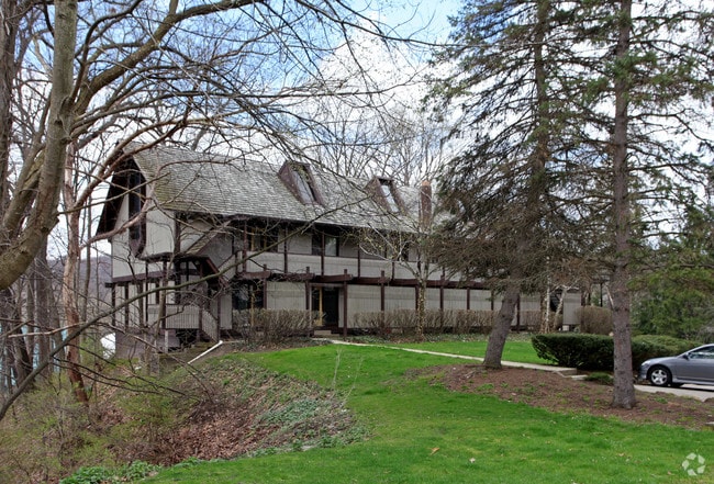
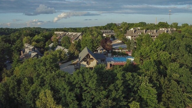
Property Detail
Akron Peninsula Rd
Akron, OH
LOT 78 NE OF AKRON PENINSULA RD 1.7357 AC
70-02859
SUMMIT
Commercialnec
Ohio
B and X Area of moderate flood hazard, usually the area between the limits of the 100-year and 500-year floods.
78
2023
1.62 AC
2025
Merriman Valley
507201
Cleveland
NEARBY LISTINGS FOR SALE OR LEASE
-
-
View all Akron listings for sale on LoopNet.com
DEMOGRAPHICS near Akron Peninsula Rd
1 mile
3 mile
5 mile
2025 Total Population
2,793
39,322
138,485
2030 Population
2,842
39,238
138,284
Pop Growth 2025-2030
+ 1.75%
(0.21%)
(0.15%)
Average Age
42
43
42
2025 Total Households
1,592
18,046
62,015
HH Growth 2025-2030
+ 1.76%
(0.18%)
(0.16%)
Median Household Inc
$64,580
$84,904
$66,433
Avg Household Size
1.70
2.10
2.10
2025 Avg HH Vehicles
2.00
2.00
2.00
Median Home Value
$292,994
$255,309
$192,044
Median Year Built
1984
1966
1958
Nearby Places
Map Layers
Map Styles
 Street
 Aerial
Transit
 Traffic
 Biking
Places
Listings with unknown addresses are not visible on the map
- Restaurants
- Banks
- Shops
- Fitness
- Groceries
PUBLIC TRANSPORTATION
COMMUTER RAIL
Botzum (National Park Scenic Railway - Cuyahoga Valley Scenic Railroad)
Drive
Walk
Distance
Botzum (National Park Scenic Railway - Cuyahoga Valley Scenic Railroad)
5 min
2.1 mi
Big Bend (National Park Scenic Railway - Cuyahoga Valley Scenic Railroad)
Drive
Walk
Distance
Big Bend (National Park Scenic Railway - Cuyahoga Valley Scenic Railroad)
6 min
2.3 mi
AIRPORT
Akron-Canton Regional
Drive
Walk
Distance
Akron-Canton Regional
33 min
20.3 mi
Cleveland-Hopkins International
Drive
Walk
Distance
Cleveland-Hopkins International
54 min
32.7 mi
Freight Ports
Port of Toledo
Drive
Walk
Distance
Port of Toledo
157 min
127.1 mi
Nearby Properties
Address
Land Use
TOTAL SIZE
Lot Size
Zoning
Address
Land Use
TOTAL SIZE
Lot Size
Zoning
245,662 SF
866.66 AC
Address
Land Use
TOTAL SIZE
Lot Size
Zoning
Address
Land Use
TOTAL SIZE
Lot Size
Zoning
282,490 SF
20.76 AC
Address
Land Use
TOTAL SIZE
Lot Size
Zoning
676,403 SF
39.06 AC
Address
Land Use
TOTAL SIZE
Lot Size
Zoning
91,104 SF
17.30 AC
Address
Land Use
TOTAL SIZE
Lot Size
Zoning
311,093 SF
32.53 AC
Address
Land Use
TOTAL SIZE
Lot Size
Zoning
479,446 SF
6.07 AC
Address
Land Use
TOTAL SIZE
Lot Size
Zoning
311,197 SF
10.78 AC
Address
Land Use
TOTAL SIZE
Lot Size
Zoning
10 AC
Address
Land Use
TOTAL SIZE
Lot Size
Zoning
313,167 SF
18.50 AC
Address
Land Use
TOTAL SIZE
Lot Size
Zoning
76,560 SF
6.07 AC
Address
Land Use
TOTAL SIZE
Lot Size
Zoning
327,798 SF
116.80 AC
Address
Land Use
TOTAL SIZE
Lot Size
Zoning
31,128 SF
1.48 AC
Address
Land Use
TOTAL SIZE
Lot Size
Zoning
Address
Land Use
TOTAL SIZE
Lot Size
Zoning
Address
Land Use
TOTAL SIZE
Lot Size
Zoning
16,057 SF
107.44 AC
Address
Land Use
TOTAL SIZE
Lot Size
Zoning
123,367 SF
8.81 AC
Address
Land Use
TOTAL SIZE
Lot Size
Zoning
Address
Land Use
TOTAL SIZE
Lot Size
Zoning
Address
Land Use
TOTAL SIZE
Lot Size
Zoning
62,100 SF
31.76 AC
Address
Land Use
TOTAL SIZE
Lot Size
Zoning
31,128 SF
5.30 AC
Address
Land Use
TOTAL SIZE
Lot Size
Zoning
63,298 SF
3.99 AC
Address
Land Use
TOTAL SIZE
Lot Size
Zoning
25,296 SF
9.36 AC
Address
Land Use
TOTAL SIZE
Lot Size
Zoning
66,362 SF
30.75 AC
Address
Land Use
TOTAL SIZE
Lot Size
Zoning
56,072 SF
12.75 AC
Address
Land Use
TOTAL SIZE
Lot Size
Zoning
51,977 SF
17.55 AC
Address
Land Use
TOTAL SIZE
Lot Size
Zoning
119,695 SF
6.52 AC
Address
Land Use
TOTAL SIZE
Lot Size
Zoning
86,366 SF
5.37 AC
Address
Land Use
TOTAL SIZE
Lot Size
Zoning
18.03 AC
Address
Land Use
TOTAL SIZE
Lot Size
Zoning
72,123 SF
0.90 AC
The World's #1 Commercial Real Estate Marketplace
Connect with us
© 2026 CoStar Group
The information above has been obtained from sources believed reliable. While we do not doubt its accuracy we have not verified it and make no guarantee, warranty or representation about it. It is your responsibility to independently confirm its accuracy and completeness. Any projections, opinions, assumptions, or estimates used are for example only and do not represent the current or future performance of the property. The value of this transaction to you depends on tax and other factors which should be evaluated by your tax, financial, and legal advisors. You and your advisors should conduct a careful, independent investigation of the property to determine to your satisfaction the suitability of the property for your needs.