Property Record
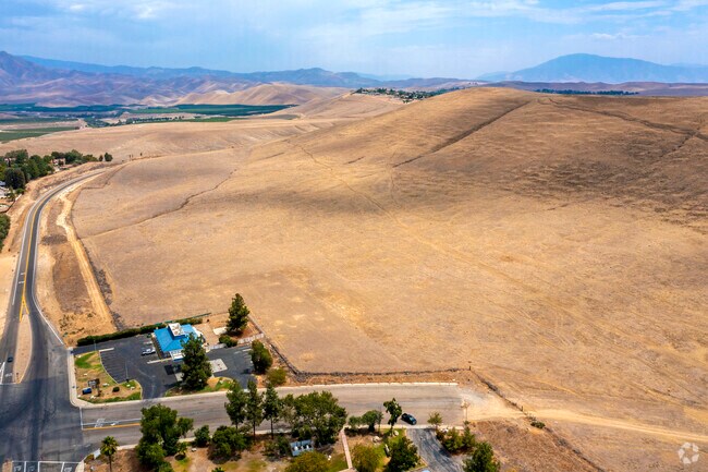
2102 Haggin Oaks Blvd, Bakersfield, CA 93311

Property Detail
2102 Haggin Oaks Blvd
386-020-14-00-0
SECTION 4 , TOWNSHIP 29 , RANGE 29 , QUARTER
Vacantlandnec
KERN
R1 R2
California
B and X Area of moderate flood hazard, usually the area between the limits of the 100-year and 500-year floods.
103.67 AC
2024
NE Outlying Kern County
2025
Bakersfield
002822
Bakersfield-Delano, CA
NEARBY LISTINGS FOR SALE OR LEASE
DEMOGRAPHICS near 2102 Haggin Oaks Blvd
1 mile
3 mile
5 mile
2024 Total Population
728
11,583
41,895
2029 Population
734
11,960
42,673
Pop Growth 2024-2029
+ 0.82%
+ 3.25%
+ 1.86%
Average Age
43
42
37
2024 Total Households
252
4,069
13,483
HH Growth 2024-2029
+ 0.79%
+ 3.00%
+ 1.79%
Median Household Inc
$85,141
$116,854
$85,506
Avg Household Size
2.70
2.80
3.00
2024 Avg HH Vehicles
2.00
2.00
2.00
Median Home Value
$427,551
$409,422
$369,860
Median Year Built
1985
2006
1990
Nearby Places
Map Layers
Map Styles
 Street
 Aerial
Transit
 Traffic
 Biking
Places
Listings with unknown addresses are not visible on the map
- Restaurants
- Banks
- Shops
- Fitness
- Groceries
PUBLIC TRANSPORTATION
AIRPORT
Meadows Field
Drive
Walk
Distance
Meadows Field
28 min
17.3 mi
Freight Ports
The Port of Hueneme
Drive
Walk
Distance
The Port of Hueneme
169 min
135.9 mi
SALE & LEASE HISTORY
LISTING DATE
SALE/LEASE

Aug 03, 2021
For Sale
Nearby Properties
Address
Land Use
TOTAL SIZE
Lot Size
Zoning
Address
Land Use
TOTAL SIZE
Lot Size
Zoning
11,267 SF
40 AC
Address
Land Use
TOTAL SIZE
Lot Size
Zoning
Address
Land Use
TOTAL SIZE
Lot Size
Zoning
398.60 AC
A
Address
Land Use
TOTAL SIZE
Lot Size
Zoning
8,039 SF
4.82 AC
Address
Land Use
TOTAL SIZE
Lot Size
Zoning
198.29 AC
A
Address
Land Use
TOTAL SIZE
Lot Size
Zoning
81.08 AC
A
Address
Land Use
TOTAL SIZE
Lot Size
Zoning
18,010 SF
176.09 AC
OS
Address
Land Use
TOTAL SIZE
Lot Size
Zoning
5,400 SF
11.30 AC
C1
Address
Land Use
TOTAL SIZE
Lot Size
Zoning
15.46 AC
C-2
Address
Land Use
TOTAL SIZE
Lot Size
Zoning
6,329 SF
0.90 AC
C-1
Address
Land Use
TOTAL SIZE
Lot Size
Zoning
19.07 AC
R2
Address
Land Use
TOTAL SIZE
Lot Size
Zoning
11.37 AC
C-0
Address
Land Use
TOTAL SIZE
Lot Size
Zoning
39,788 SF
11.51 AC
C-2/RS
Address
Land Use
TOTAL SIZE
Lot Size
Zoning
35.60 AC
R1
Address
Land Use
TOTAL SIZE
Lot Size
Zoning
4,102 SF
0.80 AC
C-1
Address
Land Use
TOTAL SIZE
Lot Size
Zoning
57.96 AC
R-1
Address
Land Use
TOTAL SIZE
Lot Size
Zoning
161.83 AC
A
Address
Land Use
TOTAL SIZE
Lot Size
Zoning
Address
Land Use
TOTAL SIZE
Lot Size
Zoning
4,720 SF
9.95 AC
C2
Address
Land Use
TOTAL SIZE
Lot Size
Zoning
2,100 SF
0.59 AC
C-1
Address
Land Use
TOTAL SIZE
Lot Size
Zoning
11,264 SF
2.47 AC
C-2
Address
Land Use
TOTAL SIZE
Lot Size
Zoning
20 AC
R1
Address
Land Use
TOTAL SIZE
Lot Size
Zoning
39.09 AC
Address
Land Use
TOTAL SIZE
Lot Size
Zoning
67.33 AC
C2
Address
Land Use
TOTAL SIZE
Lot Size
Zoning
Address
Land Use
TOTAL SIZE
Lot Size
Zoning
0.63 AC
R-1
Address
Land Use
TOTAL SIZE
Lot Size
Zoning
19.29 AC
The World's #1 Commercial Real Estate Marketplace
Connect with us
© 2026 CoStar Group
The information above has been obtained from sources believed reliable. While we do not doubt its accuracy we have not verified it and make no guarantee, warranty or representation about it. It is your responsibility to independently confirm its accuracy and completeness. Any projections, opinions, assumptions, or estimates used are for example only and do not represent the current or future performance of the property. The value of this transaction to you depends on tax and other factors which should be evaluated by your tax, financial, and legal advisors. You and your advisors should conduct a careful, independent investigation of the property to determine to your satisfaction the suitability of the property for your needs.