Property Record
Alpine Dr, Sanford, NC 27332


NEARBY LISTINGS FOR SALE OR LEASE
-
-
View all Sanford listings for sale on LoopNet.com
Property Detail
Alpine Dr
Dunn, NC
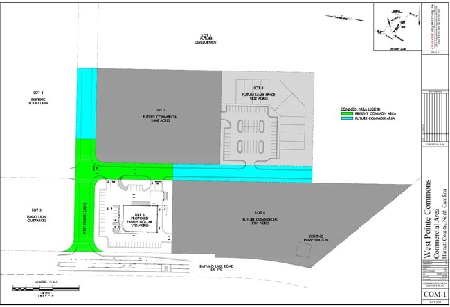
West Pointe, West
03958701 0020
67.69ACS ALLIED INVESTORS MAP#2010-674
Agriculturalland
Harnett
X
North Carolina
3710958600J
67.69 AC
2025
North Carolina Southeast Area
2025
Other Market Areas
030504
DEMOGRAPHICS near Alpine Dr
1 Mile
3 Mile
5 Mile
2024 Total Population
3,745
16,085
41,459
2029 Population
4,076
17,619
45,449
Pop Growth 2024-2029
+ 8.84%
+ 9.54%
+ 9.62%
Average Age
32
34
33
2024 Total Households
1,210
5,373
13,438
HH Growth 2024-2029
+ 9.17%
+ 9.79%
+ 9.93%
Median Household Inc
$72,177
$82,903
$79,554
Avg Household Size
3.00
2.90
3.00
2024 Avg HH Vehicles
2.00
2.00
2.00
Median Home Value
$156,916
$208,594
$215,890
Median Year Built
2002
2002
2003
Nearby Places
Map Layers
Map Styles
 Street
 Aerial
- Restaurants
- Banks
- Shops
- Fitness
- Groceries
PUBLIC TRANSPORTATION
AIRPORT
Fayetteville Regional/Grannis Field
DRIVE
WALK
Distance
Fayetteville Regional/Grannis Field
43 min
27.7 mi
Freight Ports
Port of Wilmington
DRIVE
WALK
Distance
Port of Wilmington
160 min
113.4 mi
SALE & LEASE HISTORY
LISTING DATE
SALE/LEASE

Sep 24, 2016
For Sale
Nearby Properties
Address
Land Use
TOTAL SIZE
Lot Size
Zoning
Address
Land Use
TOTAL SIZE
Lot Size
Zoning
60 AC
RA20R
Address
Land Use
TOTAL SIZE
Lot Size
Zoning
23,372 SF
7.50 AC
Address
Land Use
TOTAL SIZE
Lot Size
Zoning
9,890 SF
1.27 AC
COMM
Address
Land Use
TOTAL SIZE
Lot Size
Zoning
3,324 SF
1.77 AC
COMM
Address
Land Use
TOTAL SIZE
Lot Size
Zoning
8,439 SF
1.19 AC
COMM
Address
Land Use
TOTAL SIZE
Lot Size
Zoning
9,301 SF
1.37 AC
COMM
Address
Land Use
TOTAL SIZE
Lot Size
Zoning
12,086 SF
2.49 AC
RA20R
Address
Land Use
TOTAL SIZE
Lot Size
Zoning
420.33 AC
RA30
Address
Land Use
TOTAL SIZE
Lot Size
Zoning
10,500 SF
3.28 AC
Address
Land Use
TOTAL SIZE
Lot Size
Zoning
14,826 SF
2.15 AC
RA20R
Address
Land Use
TOTAL SIZE
Lot Size
Zoning
53.99 AC
RA20R
Address
Land Use
TOTAL SIZE
Lot Size
Zoning
4,400 SF
1.82 AC
COMM
Address
Land Use
TOTAL SIZE
Lot Size
Zoning
257.93 AC
RA20R
Address
Land Use
TOTAL SIZE
Lot Size
Zoning
6,022 SF
2.58 AC
RA20R
Address
Land Use
TOTAL SIZE
Lot Size
Zoning
1,182 SF
18.73 AC
Address
Land Use
TOTAL SIZE
Lot Size
Zoning
141 AC
RA20R
Address
Land Use
TOTAL SIZE
Lot Size
Zoning
110.81 AC
RA20R
Address
Land Use
TOTAL SIZE
Lot Size
Zoning
9,000 SF
2.18 AC
RA20M
Address
Land Use
TOTAL SIZE
Lot Size
Zoning
7,489 SF
1.75 AC
COMM
Address
Land Use
TOTAL SIZE
Lot Size
Zoning
4,500 SF
2.22 AC
RA20R
Address
Land Use
TOTAL SIZE
Lot Size
Zoning
177.99 AC
RA20R
Address
Land Use
TOTAL SIZE
Lot Size
Zoning
96.14 AC
RA20R
Address
Land Use
TOTAL SIZE
Lot Size
Zoning
3,100 SF
2.80 AC
RA20R
Address
Land Use
TOTAL SIZE
Lot Size
Zoning
162.66 AC
RA20R
Address
Land Use
TOTAL SIZE
Lot Size
Zoning
113.40 AC
RA20R
Address
Land Use
TOTAL SIZE
Lot Size
Zoning
76 AC
RA20R
Address
Land Use
TOTAL SIZE
Lot Size
Zoning
2,400 SF
3 AC
RA20R
Address
Land Use
TOTAL SIZE
Lot Size
Zoning
3,472 SF
1.18 AC
COMM
Address
Land Use
TOTAL SIZE
Lot Size
Zoning
60.91 AC
RA20R
The World's #1 Commercial Real Estate Marketplace
Connect with us
© 2026 CoStar Group
The information above has been obtained from sources believed reliable. While we do not doubt its accuracy we have not verified it and make no guarantee, warranty or representation about it. It is your responsibility to independently confirm its accuracy and completeness. Any projections, opinions, assumptions, or estimates used are for example only and do not represent the current or future performance of the property. The value of this transaction to you depends on tax and other factors which should be evaluated by your tax, financial, and legal advisors. You and your advisors should conduct a careful, independent investigation of the property to determine to your satisfaction the suitability of the property for your needs.