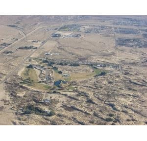
Property Record
Amboy Rd, 29 Palms, CA 92277
Property Detail
Amboy Rd
Riverside-San Bernardino-Ontario, CA
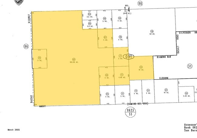
N 528 FT S 1584 FT W 412 FT SW 1/4 SEC 14 TP 1N R 9E
0622-091-02
SAN BERNARDINO
Vacantlandnec
California
AE The base floodplain where base flood elevations are provided. AE Zones are now used on new format FIRMs instead of A1-A30 Zones.
103.55 AC
2025
Twentynine Palms
2025
Inland Empire (California)
010422
NEARBY LISTINGS FOR SALE OR LEASE
DEMOGRAPHICS near Amboy Rd
1 mile
3 mile
5 mile
2025 Total Population
238
7,260
25,642
2030 Population
247
7,559
26,369
Pop Growth 2025-2030
+ 3.78%
+ 4.12%
+ 2.84%
Average Age
42
33
33
2025 Total Households
107
2,854
8,264
HH Growth 2025-2030
+ 3.74%
+ 4.34%
+ 3.86%
Median Household Inc
$100,521
$51,741
$56,980
Avg Household Size
2.20
2.40
2.50
2025 Avg HH Vehicles
2.00
2.00
2.00
Median Home Value
$225,000
$271,637
$294,746
Median Year Built
1959
1991
1988
Nearby Places
Map Layers
Map Styles
 Street
 Aerial
Layers
 Traffic
 Biking
Places
Listings with unknown addresses are not visible on the map
- Restaurants
- Banks
- Shops
- Fitness
- Groceries
Nearby Properties
Address
Land Use
TOTAL SIZE
Lot Size
Zoning
Address
Land Use
TOTAL SIZE
Lot Size
Zoning
448,671 SF
65.68 AC
Address
Land Use
TOTAL SIZE
Lot Size
Zoning
252,350 SF
29.43 AC
Address
Land Use
TOTAL SIZE
Lot Size
Zoning
35,970 SF
7.21 AC
Address
Land Use
TOTAL SIZE
Lot Size
Zoning
45,360 SF
4.23 AC
Address
Land Use
TOTAL SIZE
Lot Size
Zoning
18,072 SF
1.38 AC
Address
Land Use
TOTAL SIZE
Lot Size
Zoning
10,559 SF
1.11 AC
Address
Land Use
TOTAL SIZE
Lot Size
Zoning
45,226 SF
6.71 AC
Address
Land Use
TOTAL SIZE
Lot Size
Zoning
12,914 SF
17.06 AC
Address
Land Use
TOTAL SIZE
Lot Size
Zoning
60,440 SF
2.38 AC
Address
Land Use
TOTAL SIZE
Lot Size
Zoning
18,200 SF
7.80 AC
Address
Land Use
TOTAL SIZE
Lot Size
Zoning
18,790 SF
7.71 AC
Address
Land Use
TOTAL SIZE
Lot Size
Zoning
5,152 SF
1.20 AC
Address
Land Use
TOTAL SIZE
Lot Size
Zoning
18,735 SF
3.18 AC
Address
Land Use
TOTAL SIZE
Lot Size
Zoning
13,050 SF
15.10 AC
Address
Land Use
TOTAL SIZE
Lot Size
Zoning
62,820 SF
4.70 AC
Address
Land Use
TOTAL SIZE
Lot Size
Zoning
30,470 SF
4.62 AC
Address
Land Use
TOTAL SIZE
Lot Size
Zoning
52,123 SF
3.36 AC
Address
Land Use
TOTAL SIZE
Lot Size
Zoning
27,264 SF
4.90 AC
Address
Land Use
TOTAL SIZE
Lot Size
Zoning
4,980 SF
0.75 AC
Address
Land Use
TOTAL SIZE
Lot Size
Zoning
3,551 SF
11.70 AC
Address
Land Use
TOTAL SIZE
Lot Size
Zoning
4,054 SF
0.51 AC
Address
Land Use
TOTAL SIZE
Lot Size
Zoning
4,128 SF
0.37 AC
Address
Land Use
TOTAL SIZE
Lot Size
Zoning
6,777 SF
0.36 AC
Address
Land Use
TOTAL SIZE
Lot Size
Zoning
17.88 AC
Address
Land Use
TOTAL SIZE
Lot Size
Zoning
4,704 SF
1.42 AC
Address
Land Use
TOTAL SIZE
Lot Size
Zoning
13,738 SF
1.74 AC
Address
Land Use
TOTAL SIZE
Lot Size
Zoning
7,900 SF
1.25 AC
Address
Land Use
TOTAL SIZE
Lot Size
Zoning
8,220 SF
1.19 AC
R3
Address
Land Use
TOTAL SIZE
Lot Size
Zoning
5,428 SF
1.48 AC
Address
Land Use
TOTAL SIZE
Lot Size
Zoning
4,000 SF
1.12 AC
The World's #1 Commercial Real Estate Marketplace
Connect with us
© 2026 CoStar Group
The information above has been obtained from sources believed reliable. While we do not doubt its accuracy we have not verified it and make no guarantee, warranty or representation about it. It is your responsibility to independently confirm its accuracy and completeness. Any projections, opinions, assumptions, or estimates used are for example only and do not represent the current or future performance of the property. The value of this transaction to you depends on tax and other factors which should be evaluated by your tax, financial, and legal advisors. You and your advisors should conduct a careful, independent investigation of the property to determine to your satisfaction the suitability of the property for your needs.