Property Record
192 Broom Straw Rd, Chapin, SC 29036


Property Detail
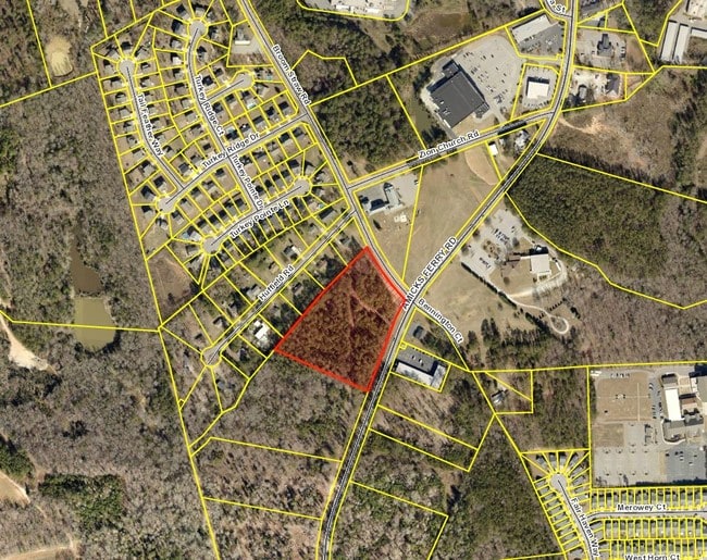
192 Broom Straw Rd
000700-09-012
WESTERN PORTION PARCEL 2
Medicalbuilding
LEXINGTON
ID
South Carolina
B and X Area of moderate flood hazard, usually the area between the limits of the 100-year and 500-year floods.
5.08 AC
2025
Dutch Fork/Irmo
2024
Columbia
021208
Columbia, SC
8,523 SF
NEARBY LISTINGS FOR SALE OR LEASE
DEMOGRAPHICS near 192 Broom Straw Rd
1 mile
3 mile
5 mile
2025 Total Population
1,803
8,812
22,643
2030 Population
1,896
9,242
23,743
Pop Growth 2025-2030
+ 5.16%
+ 4.88%
+ 4.86%
Average Age
40
41
42
2025 Total Households
705
3,338
8,681
HH Growth 2025-2030
+ 5.25%
+ 5.09%
+ 5.03%
Median Household Inc
$83,333
$88,519
$103,285
Avg Household Size
2.50
2.60
2.60
2025 Avg HH Vehicles
2.00
2.00
2.00
Median Home Value
$271,116
$307,686
$368,772
Median Year Built
2002
1999
1999
Nearby Places
Map Layers
Map Styles
 Street
 Aerial
Transit
 Traffic
 Biking
Places
Listings with unknown addresses are not visible on the map
- Restaurants
- Banks
- Shops
- Fitness
- Groceries
PUBLIC TRANSPORTATION
AIRPORT
Columbia Metro
Drive
Walk
Distance
Columbia Metro
45 min
28.7 mi
Freight Ports
North Charleston Terminal
Drive
Walk
Distance
North Charleston Terminal
144 min
125.0 mi
SALE & LEASE HISTORY
LISTING DATE
SALE/LEASE

Sep 24, 2016
For Sale
Jun 09, 2017
For Sale
Feb 22, 2021
For Sale
Feb 01, 2017
For Sale
Nearby Properties
Address
Land Use
TOTAL SIZE
Lot Size
Zoning
Address
Land Use
TOTAL SIZE
Lot Size
Zoning
Address
Land Use
TOTAL SIZE
Lot Size
Zoning
87.84 AC
Address
Land Use
TOTAL SIZE
Lot Size
Zoning
46,031 SF
12.16 AC
GC
Address
Land Use
TOTAL SIZE
Lot Size
Zoning
88 AC
RU
Address
Land Use
TOTAL SIZE
Lot Size
Zoning
61,972 SF
7.82 AC
GC
Address
Land Use
TOTAL SIZE
Lot Size
Zoning
24.64 AC
Address
Land Use
TOTAL SIZE
Lot Size
Zoning
66,432 SF
2.89 AC
GC
Address
Land Use
TOTAL SIZE
Lot Size
Zoning
100,075 SF
12.10 AC
LM
Address
Land Use
TOTAL SIZE
Lot Size
Zoning
46,244 SF
2.50 AC
INC
Address
Land Use
TOTAL SIZE
Lot Size
Zoning
20,595 SF
5.09 AC
GC
Address
Land Use
TOTAL SIZE
Lot Size
Zoning
43,119 SF
5.99 AC
GC
Address
Land Use
TOTAL SIZE
Lot Size
Zoning
32,737 SF
4.76 AC
ID
Address
Land Use
TOTAL SIZE
Lot Size
Zoning
11,300 SF
1.23 AC
ID
Address
Land Use
TOTAL SIZE
Lot Size
Zoning
7.08 AC
RU
Address
Land Use
TOTAL SIZE
Lot Size
Zoning
31,790 SF
16.26 AC
Address
Land Use
TOTAL SIZE
Lot Size
Zoning
13,310 SF
1.46 AC
GC
Address
Land Use
TOTAL SIZE
Lot Size
Zoning
15,302 SF
24.12 AC
OC
Address
Land Use
TOTAL SIZE
Lot Size
Zoning
35,515 SF
5.72 AC
GC
Address
Land Use
TOTAL SIZE
Lot Size
Zoning
18,201 SF
4.43 AC
GC
Address
Land Use
TOTAL SIZE
Lot Size
Zoning
5,124 SF
3.91 AC
GC
Address
Land Use
TOTAL SIZE
Lot Size
Zoning
203.71 AC
ID
Address
Land Use
TOTAL SIZE
Lot Size
Zoning
190,700 SF
8.18 AC
GC
Address
Land Use
TOTAL SIZE
Lot Size
Zoning
14,916 SF
1.08 AC
RS1
Address
Land Use
TOTAL SIZE
Lot Size
Zoning
39.90 AC
OC
Address
Land Use
TOTAL SIZE
Lot Size
Zoning
23.37 AC
RD
Address
Land Use
TOTAL SIZE
Lot Size
Zoning
12,074 SF
1.66 AC
GC
Address
Land Use
TOTAL SIZE
Lot Size
Zoning
35.87 AC
OC
Address
Land Use
TOTAL SIZE
Lot Size
Zoning
3,600 SF
5.60 AC
RD
Address
Land Use
TOTAL SIZE
Lot Size
Zoning
18,825 SF
5.84 AC
ID
Address
Land Use
TOTAL SIZE
Lot Size
Zoning
2,000 SF
3 AC
ID
The World's #1 Commercial Real Estate Marketplace
Connect with us
© 2026 CoStar Group
The information above has been obtained from sources believed reliable. While we do not doubt its accuracy we have not verified it and make no guarantee, warranty or representation about it. It is your responsibility to independently confirm its accuracy and completeness. Any projections, opinions, assumptions, or estimates used are for example only and do not represent the current or future performance of the property. The value of this transaction to you depends on tax and other factors which should be evaluated by your tax, financial, and legal advisors. You and your advisors should conduct a careful, independent investigation of the property to determine to your satisfaction the suitability of the property for your needs.