Property Record
Firebrand Rd, North Port, FL 34288
This Property Is For Sale
NEARBY LISTINGS FOR SALE OR LEASE
-
-
-
-
-
-
20169 20169,20177,20185,20193 KENILWORTH BOULEVARD Blvd
Port Charlotte, FL 33954
$2,800,000
4.15 AC Lots
Land
-
S Toledo Blade & Price Lane Junction
North Port, FL 34288
Rent Upon Request
28.97 - 31.97 AC Lot
Land
-
View all North Port listings for sale on LoopNet.com
Property Detail
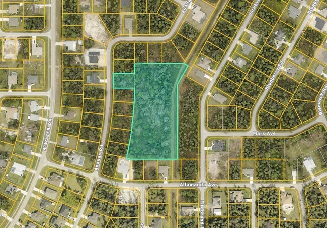
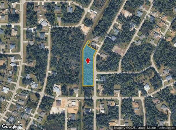
Firebrand Rd
North Port-Sarasota-Bradenton, FL
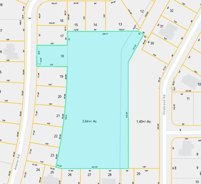
Port Charlotte Sub 24
1134-10-3346
PORTION OF TRACT D, 24TH ADD TO PORT CHARLOTTE PB 14 PG 14A-14M, BEING MORE SPECIFICALLY DESC AS BEG AT SE COR OF SAID TRACT D, TH N ALONG WLY R/W OF FIREBRAND RD, A DIST OF 325.36 FT, TH NELY
Residentialacreage
Sarasota
AE
Florida
12015C0061G
1.49 AC
2024
Sarasota Outlying
2025
Tampa/St Petersburg
002747
DEMOGRAPHICS near Firebrand Rd
1 Mile
3 Mile
5 Mile
2024 Total Population
2,792
24,895
83,360
2029 Population
3,271
29,005
96,174
Pop Growth 2024-2029
+ 17.16%
+ 16.51%
+ 15.37%
Average Age
38
44
46
2024 Total Households
969
9,385
34,526
HH Growth 2024-2029
+ 16.92%
+ 16.44%
+ 15.58%
Median Household Inc
$82,031
$78,983
$62,368
Avg Household Size
2.90
2.60
2.30
2024 Avg HH Vehicles
2.00
2.00
2.00
Median Home Value
$237,857
$261,681
$232,627
Median Year Built
2009
2003
1995
Nearby Places
- Restaurants
- Banks
- Shops
- Fitness
- Groceries
PUBLIC TRANSPORTATION
AIRPORT
Punta Gorda
DRIVE
WALK
Distance
Punta Gorda
28 min
16.9 mi
Freight Ports
Port Manatee
DRIVE
WALK
Distance
Port Manatee
80 min
62.0 mi
Nearby Properties
Address
Land Use
TOTAL SIZE
Lot Size
Zoning
Address
Land Use
TOTAL SIZE
Lot Size
Zoning
159,624 SF
57.12 AC
AC4
Address
Land Use
TOTAL SIZE
Lot Size
Zoning
135,300 SF
34.83 AC
GU
Address
Land Use
TOTAL SIZE
Lot Size
Zoning
88,808 SF
27.42 AC
GU
Address
Land Use
TOTAL SIZE
Lot Size
Zoning
37,045 SF
21.20 AC
PD
Address
Land Use
TOTAL SIZE
Lot Size
Zoning
67,750 SF
15.60 AC
OMI
Address
Land Use
TOTAL SIZE
Lot Size
Zoning
10,302 SF
2.37 AC
PD
Address
Land Use
TOTAL SIZE
Lot Size
Zoning
31.81 AC
PD
Address
Land Use
TOTAL SIZE
Lot Size
Zoning
26,870 SF
3.32 AC
CG
Address
Land Use
TOTAL SIZE
Lot Size
Zoning
27.59 AC
PD
Address
Land Use
TOTAL SIZE
Lot Size
Zoning
646.09 AC
EC
Address
Land Use
TOTAL SIZE
Lot Size
Zoning
31,637 SF
4.02 AC
RMF10
Address
Land Use
TOTAL SIZE
Lot Size
Zoning
575.38 AC
EC
Address
Land Use
TOTAL SIZE
Lot Size
Zoning
35,352 SF
2.07 AC
IG
Address
Land Use
TOTAL SIZE
Lot Size
Zoning
17,977 SF
113.25 AC
V
Address
Land Use
TOTAL SIZE
Lot Size
Zoning
87,639 SF
12.23 AC
RSF3.5
Address
Land Use
TOTAL SIZE
Lot Size
Zoning
35,144 SF
8.05 AC
II
Address
Land Use
TOTAL SIZE
Lot Size
Zoning
18,937 SF
9.87 AC
PD
Address
Land Use
TOTAL SIZE
Lot Size
Zoning
17,415 SF
9.62 AC
II
Address
Land Use
TOTAL SIZE
Lot Size
Zoning
16,284 SF
8.12 AC
IG
Address
Land Use
TOTAL SIZE
Lot Size
Zoning
18,338 SF
10 AC
RSF3.5
Address
Land Use
TOTAL SIZE
Lot Size
Zoning
21,000 SF
3.02 AC
II
Address
Land Use
TOTAL SIZE
Lot Size
Zoning
16,440 SF
3.44 AC
IG
Address
Land Use
TOTAL SIZE
Lot Size
Zoning
5,991 SF
26.17 AC
GU
Address
Land Use
TOTAL SIZE
Lot Size
Zoning
103.70 AC
AC4
Address
Land Use
TOTAL SIZE
Lot Size
Zoning
24,080 SF
8.14 AC
RSF3.5
Address
Land Use
TOTAL SIZE
Lot Size
Zoning
66.08 AC
AC4
Address
Land Use
TOTAL SIZE
Lot Size
Zoning
8,438 SF
6.18 AC
RSF3.5
Address
Land Use
TOTAL SIZE
Lot Size
Zoning
12,870 SF
1.04 AC
IG
Address
Land Use
TOTAL SIZE
Lot Size
Zoning
11,488 SF
1.56 AC
CG
Address
Land Use
TOTAL SIZE
Lot Size
Zoning
6,119 SF
6.32 AC
PKR
The World's #1 Commercial Real Estate Marketplace
Connect with us
© 2025 CoStar Group
The information above has been obtained from sources believed reliable. While we do not doubt its accuracy we have not verified it and make no guarantee, warranty or representation about it. It is your responsibility to independently confirm its accuracy and completeness. Any projections, opinions, assumptions, or estimates used are for example only and do not represent the current or future performance of the property. The value of this transaction to you depends on tax and other factors which should be evaluated by your tax, financial, and legal advisors. You and your advisors should conduct a careful, independent investigation of the property to determine to your satisfaction the suitability of the property for your needs.