Property Record
Antibes W St, Mandeville, LA 70448


Save to a Folder
{{folder.Name}}
{{folder.ListingIds.length}} Properties
{{folder.ListingIds.length}} Property
Create a New Folder
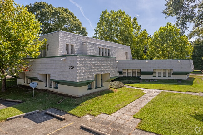
Property Detail
Antibes W St
Slidell-Mandeville-Covington, LA
LOTS 2 3 IN PARCEL G MARINERS VILLAGE CB 1013 389 CB 1102 660 CB 1086 793 CB 1011 139 CB 1212 413 CB 1316 292 CB 1344 18
59224
ST TAMMANY
Commercialnec
Louisiana
0
2
2025
Mandeville/Covington
041209
New Orleans/Metairie/Kenner
10,098 SF
NEARBY LISTINGS FOR SALE OR LEASE
DEMOGRAPHICS near Antibes W St
1 mile
3 mile
5 mile
2025 Total Population
4,370
33,854
58,240
2030 Population
4,469
34,577
59,610
Pop Growth 2025-2030
+ 2.27%
+ 2.14%
+ 2.35%
Average Age
42
42
42
2025 Total Households
1,729
13,324
22,533
HH Growth 2025-2030
+ 2.31%
+ 2.23%
+ 2.44%
Median Household Inc
$87,860
$90,881
$94,008
Avg Household Size
2.50
2.50
2.50
2025 Avg HH Vehicles
2.00
2.00
2.00
Median Home Value
$368,414
$388,604
$381,133
Median Year Built
1983
1991
1994
Nearby Places
Map Layers
Map Styles
 Street
 Aerial
Layers
 Traffic
 Biking
Places
Listings with unknown addresses are not visible on the map
- Restaurants
- Banks
- Shops
- Fitness
- Groceries
PUBLIC TRANSPORTATION
AIRPORT
Louis Armstrong New Orleans International
Drive
Walk
Distance
Louis Armstrong New Orleans International
47 min
34.2 mi
Freight Ports
Port of New Orleans
Drive
Walk
Distance
Port of New Orleans
51 min
35.2 mi
SALE & LEASE HISTORY
LISTING DATE
SALE/LEASE

Sep 25, 2016
For Lease
Nov 12, 2021
For Lease
May 06, 2019
For Lease
Dec 04, 2020
For Sale
Nearby Properties
Address
Land Use
TOTAL SIZE
Lot Size
Zoning
Address
Land Use
TOTAL SIZE
Lot Size
Zoning
Address
Land Use
TOTAL SIZE
Lot Size
Zoning
178,608 SF
34.02 AC
Address
Land Use
TOTAL SIZE
Lot Size
Zoning
229,994 SF
30 AC
Address
Land Use
TOTAL SIZE
Lot Size
Zoning
220,860 SF
25.07 AC
Address
Land Use
TOTAL SIZE
Lot Size
Zoning
154,751 SF
14.96 AC
Address
Land Use
TOTAL SIZE
Lot Size
Zoning
165,168 SF
18.16 AC
Address
Land Use
TOTAL SIZE
Lot Size
Zoning
43,301 SF
3.26 AC
Address
Land Use
TOTAL SIZE
Lot Size
Zoning
57,360 SF
2.77 AC
Address
Land Use
TOTAL SIZE
Lot Size
Zoning
119,452 SF
10.34 AC
Address
Land Use
TOTAL SIZE
Lot Size
Zoning
54,226 SF
5.10 AC
Address
Land Use
TOTAL SIZE
Lot Size
Zoning
93,800 SF
10.35 AC
Address
Land Use
TOTAL SIZE
Lot Size
Zoning
206,403 SF
9.06 AC
Address
Land Use
TOTAL SIZE
Lot Size
Zoning
50,560 SF
6.32 AC
Address
Land Use
TOTAL SIZE
Lot Size
Zoning
56,162 SF
5.30 AC
Address
Land Use
TOTAL SIZE
Lot Size
Zoning
77,388 SF
7.57 AC
Address
Land Use
TOTAL SIZE
Lot Size
Zoning
40,064 SF
3.66 AC
Address
Land Use
TOTAL SIZE
Lot Size
Zoning
90,603 SF
6.50 AC
Address
Land Use
TOTAL SIZE
Lot Size
Zoning
41,311 SF
Address
Land Use
TOTAL SIZE
Lot Size
Zoning
86,799 SF
28.55 AC
Address
Land Use
TOTAL SIZE
Lot Size
Zoning
76,264 SF
8.26 AC
Address
Land Use
TOTAL SIZE
Lot Size
Zoning
82,479 SF
5.95 AC
Address
Land Use
TOTAL SIZE
Lot Size
Zoning
61,000 SF
5.76 AC
Address
Land Use
TOTAL SIZE
Lot Size
Zoning
59,702 SF
5.97 AC
Address
Land Use
TOTAL SIZE
Lot Size
Zoning
48,307 SF
4.60 AC
Address
Land Use
TOTAL SIZE
Lot Size
Zoning
48,307 SF
4.79 AC
Address
Land Use
TOTAL SIZE
Lot Size
Zoning
50,608 SF
2.82 AC
Address
Land Use
TOTAL SIZE
Lot Size
Zoning
67,550 SF
3.66 AC
Address
Land Use
TOTAL SIZE
Lot Size
Zoning
60,971 SF
4.80 AC
Address
Land Use
TOTAL SIZE
Lot Size
Zoning
80,160 SF
1 AC
Address
Land Use
TOTAL SIZE
Lot Size
Zoning
49,690 SF
4.02 AC
The World's #1 Commercial Real Estate Marketplace
Connect with us
© 2026 CoStar Group
The information above has been obtained from sources believed reliable. While we do not doubt its accuracy we have not verified it and make no guarantee, warranty or representation about it. It is your responsibility to independently confirm its accuracy and completeness. Any projections, opinions, assumptions, or estimates used are for example only and do not represent the current or future performance of the property. The value of this transaction to you depends on tax and other factors which should be evaluated by your tax, financial, and legal advisors. You and your advisors should conduct a careful, independent investigation of the property to determine to your satisfaction the suitability of the property for your needs.