Property Record
11055 Daryl Carter Pkwy, Orlando, FL 32836
NEARBY LISTINGS FOR SALE OR LEASE
Property Detail
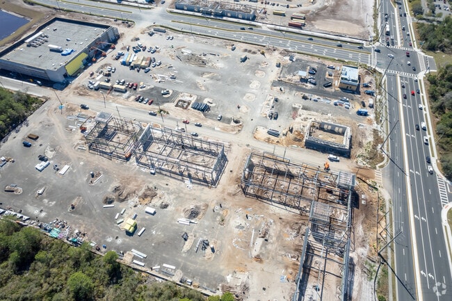
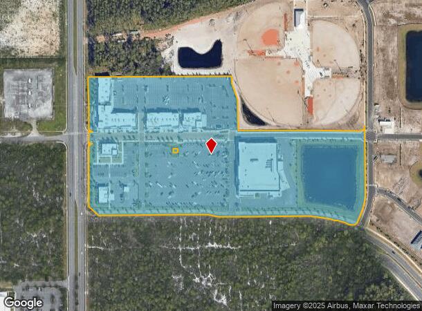
11055 Daryl Carter Pkwy
Orlando
O-Town Town Center North
Orlando-Kissimmee-Sanford, FL
O-TOWN TOWN CENTER NORTH 110/5 LOT 1
15-2428-6187-01-000
Orange
Regionalshoppingcenterormallwithanchorstore
Florida
2024
1
2025
17.98 AC
017108
Tourist Corridor
65,094 SF
DEMOGRAPHICS near 11055 Daryl Carter Pkwy
1 Mile
3 Mile
5 Mile
2024 Total Population
7,317
45,833
115,551
2029 Population
7,890
48,414
123,113
Pop Growth 2024-2029
+ 7.83%
+ 5.63%
+ 6.54%
Average Age
40
37
38
2024 Total Households
2,551
17,831
43,251
HH Growth 2024-2029
+ 7.76%
+ 5.73%
+ 6.50%
Median Household Inc
$139,112
$70,340
$76,410
Avg Household Size
2.90
2.50
2.60
2024 Avg HH Vehicles
2.00
2.00
2.00
Median Home Value
$638,241
$606,978
$402,341
Median Year Built
2008
2000
2001
Nearby Places
- Restaurants
- Banks
- Shops
- Fitness
- Groceries
PUBLIC TRANSPORTATION
AIRPORT
Orlando International
DRIVE
WALK
Distance
Orlando International
24 min
15.1 mi
Freight Ports
Port Canaveral
DRIVE
WALK
Distance
Port Canaveral
72 min
57.6 mi
Nearby Properties
Address
Land Use
TOTAL SIZE
Lot Size
Zoning
Address
Land Use
TOTAL SIZE
Lot Size
Zoning
989,892 SF
88.38 AC
H/R
Address
Land Use
TOTAL SIZE
Lot Size
Zoning
4,537,256 SF
116.95 AC
C-2
Address
Land Use
TOTAL SIZE
Lot Size
Zoning
2,991,707 SF
209.18 AC
P-D
Address
Land Use
TOTAL SIZE
Lot Size
Zoning
1,066,364 SF
44.45 AC
P-D
Address
Land Use
TOTAL SIZE
Lot Size
Zoning
2,749,886 SF
28.19 AC
C-2
Address
Land Use
TOTAL SIZE
Lot Size
Zoning
569,051 SF
82.09 AC
H/R
Address
Land Use
TOTAL SIZE
Lot Size
Zoning
1,844,212 SF
239.56 AC
H/R
Address
Land Use
TOTAL SIZE
Lot Size
Zoning
728,794 SF
26.46 AC
E
Address
Land Use
TOTAL SIZE
Lot Size
Zoning
578,603 SF
16.12 AC
P-D
Address
Land Use
TOTAL SIZE
Lot Size
Zoning
439,894 SF
16.54 AC
P-D
Address
Land Use
TOTAL SIZE
Lot Size
Zoning
1,741,717 SF
101.26 AC
C
Address
Land Use
TOTAL SIZE
Lot Size
Zoning
495,000 SF
34.56 AC
P-D
Address
Land Use
TOTAL SIZE
Lot Size
Zoning
1,644,096 SF
25.95 AC
P-D
Address
Land Use
TOTAL SIZE
Lot Size
Zoning
461,736 SF
43.80 AC
P-D
Address
Land Use
TOTAL SIZE
Lot Size
Zoning
251,593 SF
512.41 AC
P-D
Address
Land Use
TOTAL SIZE
Lot Size
Zoning
1,119,096 SF
196.40 AC
P-D
Address
Land Use
TOTAL SIZE
Lot Size
Zoning
599,757 SF
14.42 AC
P-D
Address
Land Use
TOTAL SIZE
Lot Size
Zoning
33,992 SF
Address
Land Use
TOTAL SIZE
Lot Size
Zoning
839,342 SF
22.29 AC
P-D
Address
Land Use
TOTAL SIZE
Lot Size
Zoning
565,692 SF
20.96 AC
P-D
Address
Land Use
TOTAL SIZE
Lot Size
Zoning
447,336 SF
18.45 AC
P-D
Address
Land Use
TOTAL SIZE
Lot Size
Zoning
1,560,635 SF
20.91 AC
C-2
Address
Land Use
TOTAL SIZE
Lot Size
Zoning
1,043,681 SF
25.90 AC
P-D
Address
Land Use
TOTAL SIZE
Lot Size
Zoning
472,100 SF
19.48 AC
P-D
Address
Land Use
TOTAL SIZE
Lot Size
Zoning
397,936 SF
10.38 AC
P-D
Address
Land Use
TOTAL SIZE
Lot Size
Zoning
438,160 SF
4.47 AC
P-D
Address
Land Use
TOTAL SIZE
Lot Size
Zoning
321,344 SF
18.25 AC
P-D
Address
Land Use
TOTAL SIZE
Lot Size
Zoning
732,466 SF
45.84 AC
P-D
Address
Land Use
TOTAL SIZE
Lot Size
Zoning
276,852 SF
3.04 AC
P-D
Address
Land Use
TOTAL SIZE
Lot Size
Zoning
1,052,569 SF
34.51 AC
H/R
The World's #1 Commercial Real Estate Marketplace
Connect with us
© 2025 CoStar Group
The information above has been obtained from sources believed reliable. While we do not doubt its accuracy we have not verified it and make no guarantee, warranty or representation about it. It is your responsibility to independently confirm its accuracy and completeness. Any projections, opinions, assumptions, or estimates used are for example only and do not represent the current or future performance of the property. The value of this transaction to you depends on tax and other factors which should be evaluated by your tax, financial, and legal advisors. You and your advisors should conduct a careful, independent investigation of the property to determine to your satisfaction the suitability of the property for your needs.