Property Record
Applegate Rd, Montgomery, NJ 08540
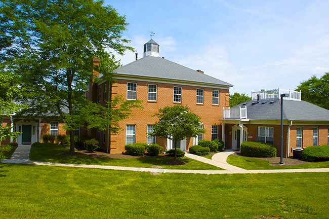
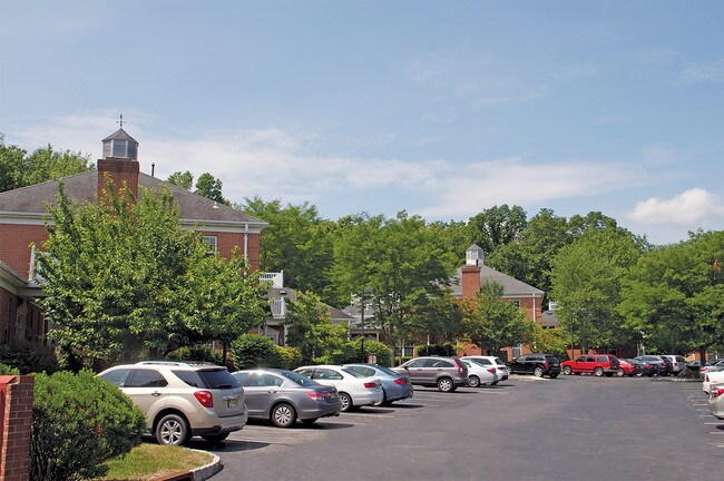
Property Detail
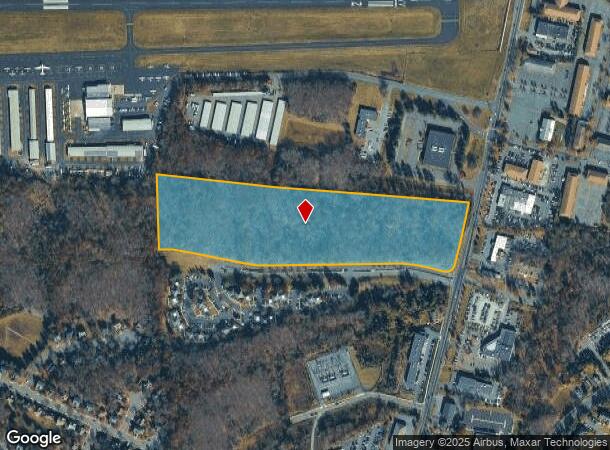
Applegate Rd
Lakewood-New Brunswick, NJ
ADDITIONAL LOTS: 58.02
13-34001-0000-00058
Somerset
Officebuilding
New Jersey
A
58
34035C0244F
29.80 AC
2024
Princeton North
2025
Northern New Jersey
004000
NEARBY LISTINGS FOR SALE OR LEASE
DEMOGRAPHICS near Applegate Rd
1 mile
3 mile
5 mile
2024 Total Population
5,365
30,143
75,497
2029 Population
5,341
30,100
75,524
Pop Growth 2024-2029
(0.45%)
(0.14%)
+ 0.04%
Average Age
42
42
41
2024 Total Households
1,985
11,223
26,713
HH Growth 2024-2029
(0.65%)
(0.34%)
+ 0.03%
Median Household Inc
$163,554
$170,747
$173,450
Avg Household Size
2.60
2.60
2.70
2024 Avg HH Vehicles
2.00
2.00
2.00
Median Home Value
$598,226
$736,867
$726,821
Median Year Built
1993
1984
1986
Nearby Places
Map Layers
Map Styles
 Street
 Aerial
Transit
 Traffic
 Biking
Places
Listings with unknown addresses are not visible on the map
- Restaurants
- Banks
- Shops
- Fitness
- Groceries
PUBLIC TRANSPORTATION
COMMUTER RAIL
Princeton (Princeton Branch - NJ Transit Commuter Rail (NJ Transit))
Drive
Walk
Distance
Princeton (Princeton Branch - NJ Transit Commuter Rail (NJ Transit))
9 min
4.4 mi
Princeton Junction (Northeast Corridor Line - NJ Transit Commuter Rail (NJ Transit), Princeton Branch - NJ Transit Commuter Rail (NJ Transit))
Drive
Walk
Distance
Princeton Junction (Northeast Corridor Line - NJ Transit Commuter Rail (NJ Transit), Princeton Branch - NJ Transit Commuter Rail (NJ Transit))
16 min
7.5 mi
AIRPORT
Trenton Mercer
Drive
Walk
Distance
Trenton Mercer
30 min
16.7 mi
Freight Ports
New York Container Terminal
Drive
Walk
Distance
New York Container Terminal
54 min
35.0 mi
SALE & LEASE HISTORY
LISTING DATE
SALE/LEASE

Sep 24, 2016
For Lease
Nearby Properties
Address
Land Use
TOTAL SIZE
Lot Size
Zoning
Address
Land Use
TOTAL SIZE
Lot Size
Zoning
8.97 AC
HMC
Address
Land Use
TOTAL SIZE
Lot Size
Zoning
115,000 SF
7.98 AC
OR2
Address
Land Use
TOTAL SIZE
Lot Size
Zoning
216,000 SF
22.79 AC
SC
Address
Land Use
TOTAL SIZE
Lot Size
Zoning
Address
Land Use
TOTAL SIZE
Lot Size
Zoning
21.79 AC
R3
Address
Land Use
TOTAL SIZE
Lot Size
Zoning
36.45 AC
E4
Address
Land Use
TOTAL SIZE
Lot Size
Zoning
0.26 AC
OR2
Address
Land Use
TOTAL SIZE
Lot Size
Zoning
30 AC
E4
Address
Land Use
TOTAL SIZE
Lot Size
Zoning
345.28 AC
M3
Address
Land Use
TOTAL SIZE
Lot Size
Zoning
27.04 AC
R1
Address
Land Use
TOTAL SIZE
Lot Size
Zoning
35.71 AC
OR1
Address
Land Use
TOTAL SIZE
Lot Size
Zoning
10 AC
OR1
Address
Land Use
TOTAL SIZE
Lot Size
Zoning
17.45 AC
HC
Address
Land Use
TOTAL SIZE
Lot Size
Zoning
5 AC
REO2
Address
Land Use
TOTAL SIZE
Lot Size
Zoning
4.09 AC
Address
Land Use
TOTAL SIZE
Lot Size
Zoning
9.92 AC
S2
Address
Land Use
TOTAL SIZE
Lot Size
Zoning
114,220 SF
18.28 AC
E2
Address
Land Use
TOTAL SIZE
Lot Size
Zoning
1,268 SF
66.60 AC
ROL
Address
Land Use
TOTAL SIZE
Lot Size
Zoning
11.86 AC
R8
Address
Land Use
TOTAL SIZE
Lot Size
Zoning
17.04 AC
HC
Address
Land Use
TOTAL SIZE
Lot Size
Zoning
125,750 SF
2.27 AC
OR2
Address
Land Use
TOTAL SIZE
Lot Size
Zoning
247.02 AC
Address
Land Use
TOTAL SIZE
Lot Size
Zoning
9.78 AC
R2
Address
Land Use
TOTAL SIZE
Lot Size
Zoning
15,176 SF
35.60 AC
RAB
Address
Land Use
TOTAL SIZE
Lot Size
Zoning
1.31 AC
E1
Address
Land Use
TOTAL SIZE
Lot Size
Zoning
28.31 AC
R2
Address
Land Use
TOTAL SIZE
Lot Size
Zoning
33,400 SF
9.25 AC
3
Address
Land Use
TOTAL SIZE
Lot Size
Zoning
64,420 SF
10.70 AC
OR2
Address
Land Use
TOTAL SIZE
Lot Size
Zoning
8.59 AC
OR2
Address
Land Use
TOTAL SIZE
Lot Size
Zoning
40.80 AC
MCRZ
The World's #1 Commercial Real Estate Marketplace
Connect with us
© 2026 CoStar Group
The information above has been obtained from sources believed reliable. While we do not doubt its accuracy we have not verified it and make no guarantee, warranty or representation about it. It is your responsibility to independently confirm its accuracy and completeness. Any projections, opinions, assumptions, or estimates used are for example only and do not represent the current or future performance of the property. The value of this transaction to you depends on tax and other factors which should be evaluated by your tax, financial, and legal advisors. You and your advisors should conduct a careful, independent investigation of the property to determine to your satisfaction the suitability of the property for your needs.