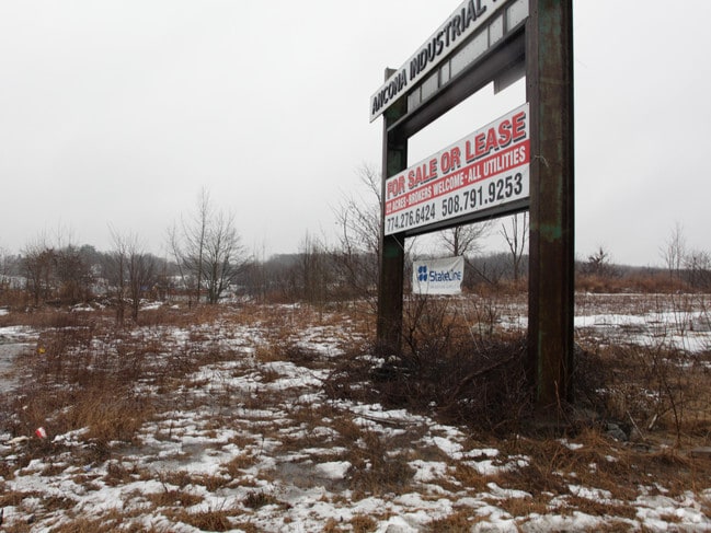
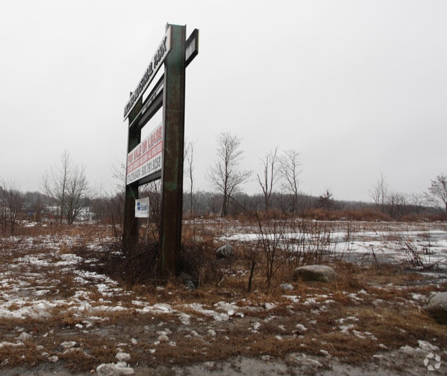
Property Record
Ararat St, Worcester, MA 01613


Property Detail
Ararat St
WORC-000037-000009-000002
WORCESTER
Industrialgeneral
Massachusetts
MG-1
2
B and X Area of moderate flood hazard, usually the area between the limits of the 100-year and 500-year floods.
9.29 AC
2024
Worcester Metro
2025
Boston
731700
Worcester, MA
NEARBY LISTINGS FOR SALE OR LEASE
DEMOGRAPHICS near Ararat St
1 mile
3 mile
5 mile
2025 Total Population
8,492
77,889
206,842
2030 Population
8,717
79,124
209,956
Pop Growth 2025-2030
+ 2.65%
+ 1.59%
+ 1.51%
Average Age
42
40
39
2025 Total Households
3,565
31,404
82,082
HH Growth 2025-2030
+ 2.83%
+ 1.73%
+ 1.63%
Median Household Inc
$97,940
$84,245
$76,971
Avg Household Size
2.30
2.40
2.40
2025 Avg HH Vehicles
2.00
2.00
2.00
Median Home Value
$383,142
$410,063
$436,689
Median Year Built
1974
1958
1956
Nearby Places
Map Layers
Map Styles
 Street
 Aerial
Layers
 Traffic
 Biking
Places
Listings with unknown addresses are not visible on the map
- Restaurants
- Banks
- Shops
- Fitness
- Groceries
PUBLIC TRANSPORTATION
COMMUTER RAIL
Worcester Union Station (Lake Shore Limited - Amtrak)
Drive
Walk
Distance
Worcester Union Station (Lake Shore Limited - Amtrak)
7 min
3.6 mi
Worcester (Framingham/Worcester Line - Massachusetts Bay Transportation Authority Commuter Rail (Purple Line))
Drive
Walk
Distance
Worcester (Framingham/Worcester Line - Massachusetts Bay Transportation Authority Commuter Rail (Purple Line))
7 min
3.6 mi
AIRPORT
Worcester Regional
Drive
Walk
Distance
Worcester Regional
17 min
7.2 mi
Freight Ports
Port of Boston
Drive
Walk
Distance
Port of Boston
67 min
45.3 mi
Nearby Properties
Address
Land Use
TOTAL SIZE
Lot Size
Zoning
Address
Land Use
TOTAL SIZE
Lot Size
Zoning
381,440 SF
2.74 AC
BG-6
Address
Land Use
TOTAL SIZE
Lot Size
Zoning
457,170 SF
29.92 AC
ML-.5
Address
Land Use
TOTAL SIZE
Lot Size
Zoning
20.01 AC
BG-2
Address
Land Use
TOTAL SIZE
Lot Size
Zoning
155,421 SF
65.04 AC
RL-7
Address
Land Use
TOTAL SIZE
Lot Size
Zoning
524,527 SF
45.16 AC
BL-1
Address
Land Use
TOTAL SIZE
Lot Size
Zoning
51.05 AC
BO-1
Address
Land Use
TOTAL SIZE
Lot Size
Zoning
50.11 AC
RS-7
Address
Land Use
TOTAL SIZE
Lot Size
Zoning
3.85 AC
RG-5
Address
Land Use
TOTAL SIZE
Lot Size
Zoning
117,645 SF
3.11 AC
BO-1
Address
Land Use
TOTAL SIZE
Lot Size
Zoning
16,404 SF
10.80 AC
RS-10
Address
Land Use
TOTAL SIZE
Lot Size
Zoning
126,849 SF
15.18 AC
R15
Address
Land Use
TOTAL SIZE
Lot Size
Zoning
157,385 SF
3.45 AC
BG-6
Address
Land Use
TOTAL SIZE
Lot Size
Zoning
30.93 AC
RG-5
Address
Land Use
TOTAL SIZE
Lot Size
Zoning
291,410 SF
21.73 AC
RL-7
Address
Land Use
TOTAL SIZE
Lot Size
Zoning
44,584 SF
90.22 AC
Address
Land Use
TOTAL SIZE
Lot Size
Zoning
15.42 AC
RG-5
Address
Land Use
TOTAL SIZE
Lot Size
Zoning
194,264 SF
4.32 AC
BL-1
Address
Land Use
TOTAL SIZE
Lot Size
Zoning
3.97 AC
BG-6
Address
Land Use
TOTAL SIZE
Lot Size
Zoning
15.37 AC
RS-7
Address
Land Use
TOTAL SIZE
Lot Size
Zoning
181,408 SF
1.50 AC
BG-6
Address
Land Use
TOTAL SIZE
Lot Size
Zoning
491,632 SF
1.59 AC
RL-7
Address
Land Use
TOTAL SIZE
Lot Size
Zoning
120,046 SF
6.90 AC
RG-5
Address
Land Use
TOTAL SIZE
Lot Size
Zoning
118,682 SF
7.33 AC
RG-5
Address
Land Use
TOTAL SIZE
Lot Size
Zoning
118,381 SF
12.61 AC
RG-5
Address
Land Use
TOTAL SIZE
Lot Size
Zoning
13.95 AC
RG-5
Address
Land Use
TOTAL SIZE
Lot Size
Zoning
286,338 SF
33.45 AC
RL-7
Address
Land Use
TOTAL SIZE
Lot Size
Zoning
120,732 SF
28.92 AC
RS-10
Address
Land Use
TOTAL SIZE
Lot Size
Zoning
121,780 SF
1.39 AC
BG-6
Address
Land Use
TOTAL SIZE
Lot Size
Zoning
188,980 SF
20 AC
RL-7
Address
Land Use
TOTAL SIZE
Lot Size
Zoning
64,709 SF
1.80 AC
RS-10
The World's #1 Commercial Real Estate Marketplace
Connect with us
© 2026 CoStar Group
The information above has been obtained from sources believed reliable. While we do not doubt its accuracy we have not verified it and make no guarantee, warranty or representation about it. It is your responsibility to independently confirm its accuracy and completeness. Any projections, opinions, assumptions, or estimates used are for example only and do not represent the current or future performance of the property. The value of this transaction to you depends on tax and other factors which should be evaluated by your tax, financial, and legal advisors. You and your advisors should conduct a careful, independent investigation of the property to determine to your satisfaction the suitability of the property for your needs.