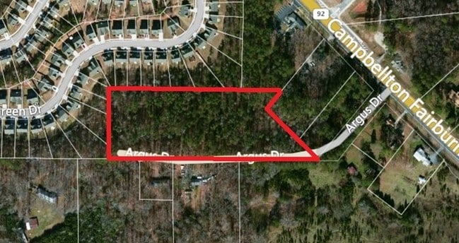
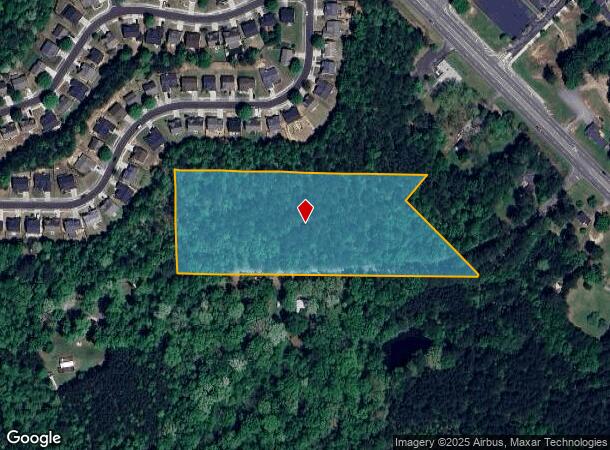
Property Record
Nw Argus Dr, Fairburn, GA 30213
NEARBY LISTINGS FOR SALE OR LEASE
Property Detail
Nw Argus Dr
Atlanta-Sandy Springs-Roswell, GA
Survey Timothy Watson & June S
09F-2002-0091-008-2
SUBDIVISION NEW FOR 2007 NO SIGN OF NAME9/06
Residentialacreage
Fulton
X
Georgia
13121C0453F
90
2024
6.94 AC
2025
North Clayton/Airport
010535
Atlanta
DEMOGRAPHICS near Nw Argus Dr
1 Mile
3 Mile
5 Mile
2024 Total Population
4,578
38,346
85,527
2029 Population
4,702
39,666
88,461
Pop Growth 2024-2029
+ 2.71%
+ 3.44%
+ 3.43%
Average Age
38
37
37
2024 Total Households
1,525
13,666
31,221
HH Growth 2024-2029
+ 2.89%
+ 3.49%
+ 3.49%
Median Household Inc
$73,845
$67,682
$69,216
Avg Household Size
2.90
2.70
2.70
2024 Avg HH Vehicles
2.00
2.00
2.00
Median Home Value
$232,109
$226,444
$231,260
Median Year Built
2000
2003
2002
Nearby Places
Map Layers
Map Styles
 Street
 Aerial
- Restaurants
- Banks
- Shops
- Fitness
- Groceries
PUBLIC TRANSPORTATION
AIRPORT
Hartsfield - Jackson Atlanta International
DRIVE
WALK
Distance
Hartsfield - Jackson Atlanta International
24 min
15.0 mi
Freight Ports
Georgia Ports - Savannah
DRIVE
WALK
Distance
Georgia Ports - Savannah
286 min
250.1 mi
SALE & LEASE HISTORY
LISTING DATE
SALE/LEASE

Sep 24, 2016
For Sale
Nearby Properties
Address
Land Use
TOTAL SIZE
Lot Size
Zoning
Address
Land Use
TOTAL SIZE
Lot Size
Zoning
938,714 SF
103.25 AC
AG1
Address
Land Use
TOTAL SIZE
Lot Size
Zoning
14.13 AC
TCMU
Address
Land Use
TOTAL SIZE
Lot Size
Zoning
74.44 AC
Address
Land Use
TOTAL SIZE
Lot Size
Zoning
545,664 SF
27.64 AC
AG1
Address
Land Use
TOTAL SIZE
Lot Size
Zoning
595,060 SF
62.71 AC
Address
Land Use
TOTAL SIZE
Lot Size
Zoning
1,226,360 SF
18.72 AC
AG1
Address
Land Use
TOTAL SIZE
Lot Size
Zoning
78.33 AC
Address
Land Use
TOTAL SIZE
Lot Size
Zoning
1,776,355 SF
13.40 AC
PD
Address
Land Use
TOTAL SIZE
Lot Size
Zoning
1,040,000 SF
74.64 AC
AG1
Address
Land Use
TOTAL SIZE
Lot Size
Zoning
873,600 SF
65.24 AC
C2
Address
Land Use
TOTAL SIZE
Lot Size
Zoning
798,272 SF
18.32 AC
M1A
Address
Land Use
TOTAL SIZE
Lot Size
Zoning
1,873,575 SF
50.47 AC
RM
Address
Land Use
TOTAL SIZE
Lot Size
Zoning
2,042,096 SF
30.07 AC
MIXU
Address
Land Use
TOTAL SIZE
Lot Size
Zoning
14.83 AC
AG1
Address
Land Use
TOTAL SIZE
Lot Size
Zoning
156,882 SF
25 AC
AG1
Address
Land Use
TOTAL SIZE
Lot Size
Zoning
130,516 SF
6.50 AC
C1
Address
Land Use
TOTAL SIZE
Lot Size
Zoning
572,000 SF
46.35 AC
AG1
Address
Land Use
TOTAL SIZE
Lot Size
Zoning
567,000 SF
41.83 AC
AG1
Address
Land Use
TOTAL SIZE
Lot Size
Zoning
499,950 SF
63.40 AC
AG1
Address
Land Use
TOTAL SIZE
Lot Size
Zoning
1,320,344 SF
0.35 AC
MIX
Address
Land Use
TOTAL SIZE
Lot Size
Zoning
661,312 SF
11.40 AC
RM
Address
Land Use
TOTAL SIZE
Lot Size
Zoning
23 AC
AG1
Address
Land Use
TOTAL SIZE
Lot Size
Zoning
32.52 AC
C2
Address
Land Use
TOTAL SIZE
Lot Size
Zoning
24.53 AC
Address
Land Use
TOTAL SIZE
Lot Size
Zoning
1,566 SF
41.68 AC
AG1
Address
Land Use
TOTAL SIZE
Lot Size
Zoning
1,221 SF
10 AC
RM
Address
Land Use
TOTAL SIZE
Lot Size
Zoning
327,822 SF
0.16 AC
MIX
Address
Land Use
TOTAL SIZE
Lot Size
Zoning
242,550 SF
15.82 AC
AG1
Address
Land Use
TOTAL SIZE
Lot Size
Zoning
169,212 SF
0.20 AC
MIX
Address
Land Use
TOTAL SIZE
Lot Size
Zoning
12,406 SF
4.88 AC
M1
The World's #1 Commercial Real Estate Marketplace
Connect with us
© 2025 CoStar Group
The information above has been obtained from sources believed reliable. While we do not doubt its accuracy we have not verified it and make no guarantee, warranty or representation about it. It is your responsibility to independently confirm its accuracy and completeness. Any projections, opinions, assumptions, or estimates used are for example only and do not represent the current or future performance of the property. The value of this transaction to you depends on tax and other factors which should be evaluated by your tax, financial, and legal advisors. You and your advisors should conduct a careful, independent investigation of the property to determine to your satisfaction the suitability of the property for your needs.