Property Record
Arnold Rd, Jacksonville, FL 32218
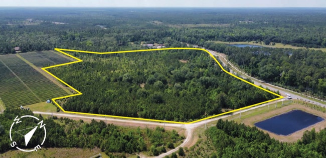

This Property Is For Sale
Property Detail
Arnold Rd
Jacksonville, FL
6-70 39-1N-26E 30.77 1-150 TISONS S/D LOT 3 RECD O/R 20689-1983
019619-0135
DUVAL
Industrialacreage
Florida
IL
3
2025
30.78 AC
2026
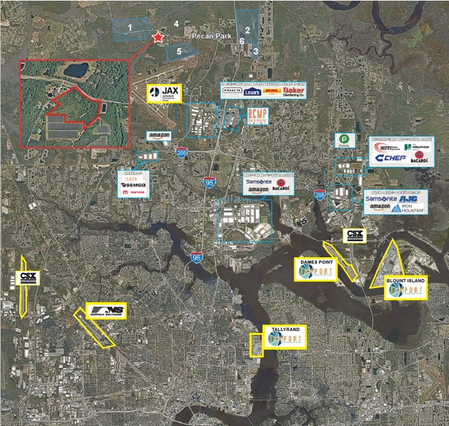
Northeast Jacksonville
010308
Jacksonville (Florida)
NEARBY LISTINGS FOR SALE OR LEASE
DEMOGRAPHICS near Arnold Rd
1 mile
3 mile
5 mile
2025 Total Population
168
4,196
26,768
2030 Population
180
4,484
28,910
Pop Growth 2025-2030
+ 7.14%
+ 6.86%
+ 8.00%
Average Age
39
39
38
2025 Total Households
53
1,317
9,990
HH Growth 2025-2030
+ 7.55%
+ 7.29%
+ 8.54%
Median Household Inc
$92,045
$91,130
$80,348
Avg Household Size
2.80
2.80
2.60
2025 Avg HH Vehicles
2.00
2.00
2.00
Median Home Value
$336,111
$339,357
$330,065
Median Year Built
2010
2010
2008
Nearby Places
Map Layers
Map Styles
 Street
 Aerial
Transit
 Traffic
 Biking
Places
Listings with unknown addresses are not visible on the map
- Restaurants
- Banks
- Shops
- Fitness
- Groceries
PUBLIC TRANSPORTATION
AIRPORT
Jacksonville International
Drive
Walk
Distance
Jacksonville International
11 min
4.1 mi
Freight Ports
Jacksonville Port
Drive
Walk
Distance
Jacksonville Port
26 min
17.6 mi
Nearby Properties
Address
Land Use
TOTAL SIZE
Lot Size
Zoning
Address
Land Use
TOTAL SIZE
Lot Size
Zoning
2,999,392 SF
5,204.78 AC
PUD
Address
Land Use
TOTAL SIZE
Lot Size
Zoning
640,660 SF
28.30 AC
PUD
Address
Land Use
TOTAL SIZE
Lot Size
Zoning
197,526 SF
11.98 AC
PUD
Address
Land Use
TOTAL SIZE
Lot Size
Zoning
149,367 SF
810.98 AC
PUD
Address
Land Use
TOTAL SIZE
Lot Size
Zoning
201,300 SF
15.83 AC
PUD
Address
Land Use
TOTAL SIZE
Lot Size
Zoning
104,322 SF
5.20 AC
PBF-3
Address
Land Use
TOTAL SIZE
Lot Size
Zoning
101.11 AC
PUD
Address
Land Use
TOTAL SIZE
Lot Size
Zoning
8,916 SF
26.61 AC
PUD
Address
Land Use
TOTAL SIZE
Lot Size
Zoning
86,615 SF
398.67 AC
PBF-1
Address
Land Use
TOTAL SIZE
Lot Size
Zoning
602.71 AC
PUD
Address
Land Use
TOTAL SIZE
Lot Size
Zoning
30,727 SF
13.71 AC
CCG-1
Address
Land Use
TOTAL SIZE
Lot Size
Zoning
35,256 SF
34.79 AC
PUD
Address
Land Use
TOTAL SIZE
Lot Size
Zoning
9,962 SF
39.37 AC
PUD
Address
Land Use
TOTAL SIZE
Lot Size
Zoning
162,456 SF
19.47 AC
PBF-3
Address
Land Use
TOTAL SIZE
Lot Size
Zoning
101,126 SF
20.86 AC
CCG-2
Address
Land Use
TOTAL SIZE
Lot Size
Zoning
120.03 AC
PUD
Address
Land Use
TOTAL SIZE
Lot Size
Zoning
14,448 SF
7.15 AC
CCG-1
Address
Land Use
TOTAL SIZE
Lot Size
Zoning
Address
Land Use
TOTAL SIZE
Lot Size
Zoning
19,007 SF
289.87 AC
PBF-1
Address
Land Use
TOTAL SIZE
Lot Size
Zoning
6,514 SF
16.51 AC
IL
Address
Land Use
TOTAL SIZE
Lot Size
Zoning
3,940 SF
46.61 AC
PUD
Address
Land Use
TOTAL SIZE
Lot Size
Zoning
7,376 SF
1.22 AC
CCG-1
Address
Land Use
TOTAL SIZE
Lot Size
Zoning
98.75 AC
IL
Address
Land Use
TOTAL SIZE
Lot Size
Zoning
57.05 AC
PUD
Address
Land Use
TOTAL SIZE
Lot Size
Zoning
40.46 AC
PUD
Address
Land Use
TOTAL SIZE
Lot Size
Zoning
2,796 SF
18.20 AC
IL
Address
Land Use
TOTAL SIZE
Lot Size
Zoning
2,880 SF
2.70 AC
CCG-2
Address
Land Use
TOTAL SIZE
Lot Size
Zoning
51,279 SF
9.94 AC
PBF-3
Address
Land Use
TOTAL SIZE
Lot Size
Zoning
16,010 SF
4.81 AC
CCG-1
The World's #1 Commercial Real Estate Marketplace
Connect with us
© 2026 CoStar Group
The information above has been obtained from sources believed reliable. While we do not doubt its accuracy we have not verified it and make no guarantee, warranty or representation about it. It is your responsibility to independently confirm its accuracy and completeness. Any projections, opinions, assumptions, or estimates used are for example only and do not represent the current or future performance of the property. The value of this transaction to you depends on tax and other factors which should be evaluated by your tax, financial, and legal advisors. You and your advisors should conduct a careful, independent investigation of the property to determine to your satisfaction the suitability of the property for your needs.