Property Record
Ashley Phosphate Rd, North Charleston, SC 29418
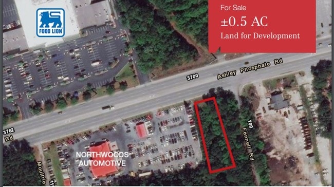
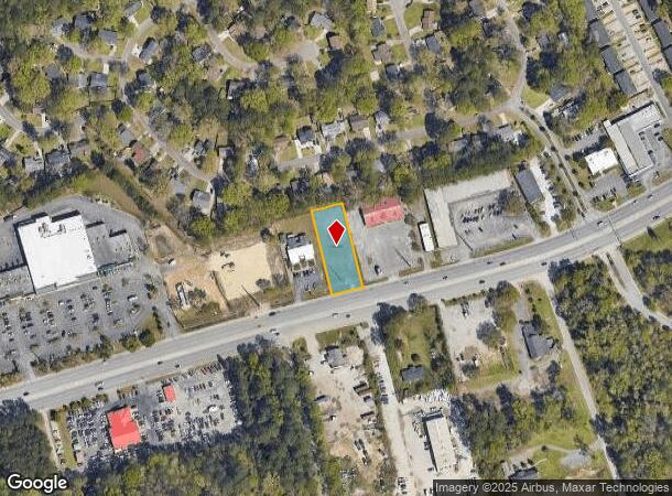
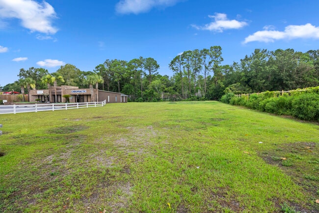
This Property Is For Sale
NEARBY LISTINGS FOR SALE OR LEASE
Property Detail
Ashley Phosphate Rd
172-12-01-031
PARCEL B-2
Commercialnec
Dorchester
ARE
South Carolina
45019C0290K
0.56 AC
2025
Dorchester County
2025
Charleston/N Charleston
003200
Charleston-North Charleston, SC
DEMOGRAPHICS near Ashley Phosphate Rd
1 Mile
3 Mile
5 Mile
2024 Total Population
8,012
59,116
131,752
2029 Population
8,601
63,094
143,259
Pop Growth 2024-2029
+ 7.35%
+ 6.73%
+ 8.73%
Average Age
36
36
36
2024 Total Households
2,920
23,032
51,199
HH Growth 2024-2029
+ 7.19%
+ 6.56%
+ 8.56%
Median Household Inc
$54,245
$61,117
$63,486
Avg Household Size
2.60
2.50
2.50
2024 Avg HH Vehicles
2.00
2.00
2.00
Median Home Value
$176,610
$242,763
$243,658
Median Year Built
1986
1996
1997
Nearby Places
Map Layers
Map Styles
 Street
 Aerial
- Restaurants
- Banks
- Shops
- Fitness
- Groceries
PUBLIC TRANSPORTATION
COMMUTER RAIL
DRIVE
WALK
Distance
13 min
8.0 mi
AIRPORT
Charleston AFB/International
DRIVE
WALK
Distance
Charleston AFB/International
10 min
6.0 mi
Nearby Properties
Address
Land Use
TOTAL SIZE
Lot Size
Zoning
Address
Land Use
TOTAL SIZE
Lot Size
Zoning
Address
Land Use
TOTAL SIZE
Lot Size
Zoning
48.89 AC
Address
Land Use
TOTAL SIZE
Lot Size
Zoning
1,430 SF
28.27 AC
Address
Land Use
TOTAL SIZE
Lot Size
Zoning
Address
Land Use
TOTAL SIZE
Lot Size
Zoning
10,172 SF
12.76 AC
Address
Land Use
TOTAL SIZE
Lot Size
Zoning
7,200 SF
8.73 AC
Address
Land Use
TOTAL SIZE
Lot Size
Zoning
14.75 AC
Address
Land Use
TOTAL SIZE
Lot Size
Zoning
16.40 AC
Address
Land Use
TOTAL SIZE
Lot Size
Zoning
1,272 SF
18.46 AC
Address
Land Use
TOTAL SIZE
Lot Size
Zoning
33.62 AC
Address
Land Use
TOTAL SIZE
Lot Size
Zoning
199,300 SF
13.28 AC
Address
Land Use
TOTAL SIZE
Lot Size
Zoning
126,385 SF
13.45 AC
Address
Land Use
TOTAL SIZE
Lot Size
Zoning
133.75 AC
MUC_DC
Address
Land Use
TOTAL SIZE
Lot Size
Zoning
67,082 SF
12.07 AC
Address
Land Use
TOTAL SIZE
Lot Size
Zoning
48,400 SF
5.76 AC
Address
Land Use
TOTAL SIZE
Lot Size
Zoning
44,300 SF
2.34 AC
Address
Land Use
TOTAL SIZE
Lot Size
Zoning
33.88 AC
Address
Land Use
TOTAL SIZE
Lot Size
Zoning
Address
Land Use
TOTAL SIZE
Lot Size
Zoning
293,825 SF
30.43 AC
Address
Land Use
TOTAL SIZE
Lot Size
Zoning
22,246 SF
5.25 AC
Address
Land Use
TOTAL SIZE
Lot Size
Zoning
1.26 AC
Address
Land Use
TOTAL SIZE
Lot Size
Zoning
1,075 SF
15.81 AC
Address
Land Use
TOTAL SIZE
Lot Size
Zoning
1,286 SF
20 AC
R-2_NC
Address
Land Use
TOTAL SIZE
Lot Size
Zoning
332,013 SF
74.26 AC
R-3_NC
Address
Land Use
TOTAL SIZE
Lot Size
Zoning
384,000 SF
23.95 AC
PDD_NC
Address
Land Use
TOTAL SIZE
Lot Size
Zoning
17,272 SF
3.02 AC
Address
Land Use
TOTAL SIZE
Lot Size
Zoning
5,125 SF
15.99 AC
R-2_NC
Address
Land Use
TOTAL SIZE
Lot Size
Zoning
13,012 SF
1.40 AC
Address
Land Use
TOTAL SIZE
Lot Size
Zoning
16,000 SF
2.61 AC
Address
Land Use
TOTAL SIZE
Lot Size
Zoning
9,241 SF
9.66 AC
PDD_NC
The World's #1 Commercial Real Estate Marketplace
Connect with us
© 2026 CoStar Group
The information above has been obtained from sources believed reliable. While we do not doubt its accuracy we have not verified it and make no guarantee, warranty or representation about it. It is your responsibility to independently confirm its accuracy and completeness. Any projections, opinions, assumptions, or estimates used are for example only and do not represent the current or future performance of the property. The value of this transaction to you depends on tax and other factors which should be evaluated by your tax, financial, and legal advisors. You and your advisors should conduct a careful, independent investigation of the property to determine to your satisfaction the suitability of the property for your needs.