Property Record
Ashton Rd, Ashton, MD
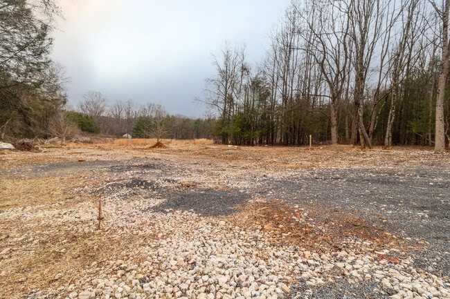
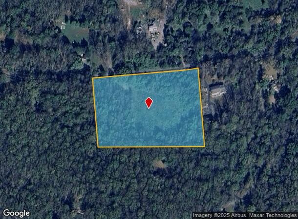

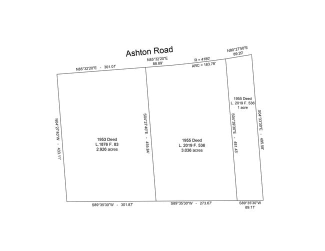
This Property Is For Sale
Property Detail
Ashton Rd
Washington-Arlington-Alexandria, DC-VA-MD-WV
Brooke Grove
08-00719151
SNOWDEN MANOR
Vacantlandnec
Montgomery
X
Maryland
24027C0140D
6.90 AC
2024
Outlying Montgmery Cnty E
2025
Washington, DC
701316
NEARBY LISTINGS FOR SALE OR LEASE
DEMOGRAPHICS near Ashton Rd
1 mile
3 mile
5 mile
2024 Total Population
674
13,389
76,193
2029 Population
674
13,502
76,316
Pop Growth 2024-2029
0.00%
+ 0.84%
+ 0.16%
Average Age
44
43
42
2024 Total Households
221
4,266
24,632
HH Growth 2024-2029
0.00%
+ 0.75%
(0.01%)
Median Household Inc
$191,666
$175,107
$171,009
Avg Household Size
2.90
3.00
3.00
2024 Avg HH Vehicles
3.00
3.00
2.00
Median Home Value
$780,645
$793,655
$713,024
Median Year Built
1977
1986
1988
Nearby Places
Map Layers
Map Styles
 Street
 Aerial
Transit
 Traffic
 Biking
Places
Listings with unknown addresses are not visible on the map
- Restaurants
- Banks
- Shops
- Fitness
- Groceries
PUBLIC TRANSPORTATION
AIRPORT
Baltimore/Washington International Thurgood Marshall
Drive
Walk
Distance
Baltimore/Washington International Thurgood Marshall
34 min
23.1 mi
Ronald Reagan Washington Ntl
Drive
Walk
Distance
Ronald Reagan Washington Ntl
45 min
26.1 mi
Washington Dulles International
Drive
Walk
Distance
Washington Dulles International
65 min
40.1 mi
Freight Ports
Port of Baltimore
Drive
Walk
Distance
Port of Baltimore
38 min
25.7 mi
Nearby Properties
Address
Land Use
TOTAL SIZE
Lot Size
Zoning
Address
Land Use
TOTAL SIZE
Lot Size
Zoning
289,712 SF
19.79 AC
RNC
Address
Land Use
TOTAL SIZE
Lot Size
Zoning
143,000 SF
20.01 AC
RC
Address
Land Use
TOTAL SIZE
Lot Size
Zoning
172.63 AC
RRDEO
Address
Land Use
TOTAL SIZE
Lot Size
Zoning
1,056 SF
20.99 AC
RRDEO
Address
Land Use
TOTAL SIZE
Lot Size
Zoning
47,821 SF
2.67 AC
CRN07
Address
Land Use
TOTAL SIZE
Lot Size
Zoning
13.56 AC
B2PEC
Address
Land Use
TOTAL SIZE
Lot Size
Zoning
42,861 SF
6.57 AC
RE1
Address
Land Use
TOTAL SIZE
Lot Size
Zoning
20,000 SF
2.53 AC
PD5
Address
Land Use
TOTAL SIZE
Lot Size
Zoning
35,802 SF
17.50 AC
RRDEO
Address
Land Use
TOTAL SIZE
Lot Size
Zoning
32,145 SF
7.24 AC
RC
Address
Land Use
TOTAL SIZE
Lot Size
Zoning
12,775 SF
1.53 AC
CRT12
Address
Land Use
TOTAL SIZE
Lot Size
Zoning
9,901 SF
1.37 AC
RRDEO
Address
Land Use
TOTAL SIZE
Lot Size
Zoning
10,406 SF
3.69 AC
B1
Address
Land Use
TOTAL SIZE
Lot Size
Zoning
14,800 SF
7.43 AC
RE2
Address
Land Use
TOTAL SIZE
Lot Size
Zoning
10,638 SF
3.55 AC
RRDEO
Address
Land Use
TOTAL SIZE
Lot Size
Zoning
9,700 SF
2.87 AC
RE2
Address
Land Use
TOTAL SIZE
Lot Size
Zoning
16,000 SF
0.84 AC
CRT07
Address
Land Use
TOTAL SIZE
Lot Size
Zoning
10,385 SF
3 AC
RRDEO
Address
Land Use
TOTAL SIZE
Lot Size
Zoning
16,615 SF
1.75 AC
CRN0.
Address
Land Use
TOTAL SIZE
Lot Size
Zoning
3,250 SF
1.21 AC
NR0.7
Address
Land Use
TOTAL SIZE
Lot Size
Zoning
5,287 SF
3.58 AC
RRDEO
Address
Land Use
TOTAL SIZE
Lot Size
Zoning
13,000 SF
6.82 AC
RE2
Address
Land Use
TOTAL SIZE
Lot Size
Zoning
22,284 SF
6.43 AC
R200
Address
Land Use
TOTAL SIZE
Lot Size
Zoning
10,057 SF
6.30 AC
RRDEO
Address
Land Use
TOTAL SIZE
Lot Size
Zoning
10,430 SF
3.06 AC
Address
Land Use
TOTAL SIZE
Lot Size
Zoning
1,768 SF
7.30 AC
B1 B2
Address
Land Use
TOTAL SIZE
Lot Size
Zoning
5,811 SF
0.50 AC
CRN07
Address
Land Use
TOTAL SIZE
Lot Size
Zoning
11,787 SF
7.51 AC
RRDEO
Address
Land Use
TOTAL SIZE
Lot Size
Zoning
10,901 SF
3.17 AC
RRDEO
Address
Land Use
TOTAL SIZE
Lot Size
Zoning
6,508 SF
4.30 AC
RE2
The World's #1 Commercial Real Estate Marketplace
Connect with us
© 2026 CoStar Group
The information above has been obtained from sources believed reliable. While we do not doubt its accuracy we have not verified it and make no guarantee, warranty or representation about it. It is your responsibility to independently confirm its accuracy and completeness. Any projections, opinions, assumptions, or estimates used are for example only and do not represent the current or future performance of the property. The value of this transaction to you depends on tax and other factors which should be evaluated by your tax, financial, and legal advisors. You and your advisors should conduct a careful, independent investigation of the property to determine to your satisfaction the suitability of the property for your needs.