Property Record
5398 Atlanta Hwy, Bogart, GA 30622
NEARBY LISTINGS FOR SALE OR LEASE
Property Detail
5398 Atlanta Hwy
Athens-Clarke County, GA
Com-St-010->15-25
043-002
Clarke
Sfr
Georgia
X
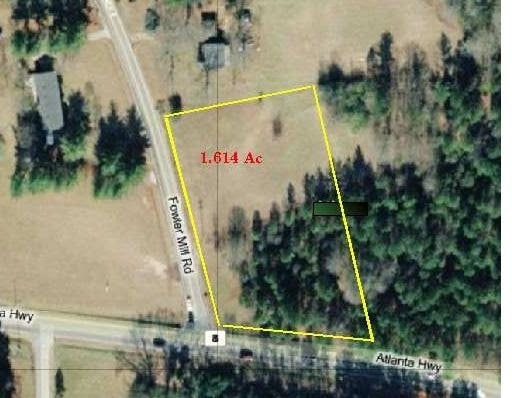
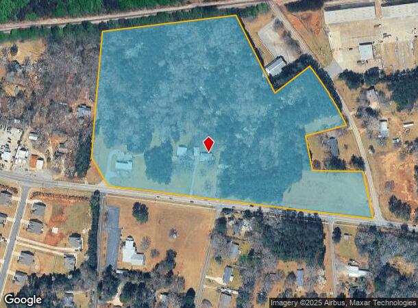
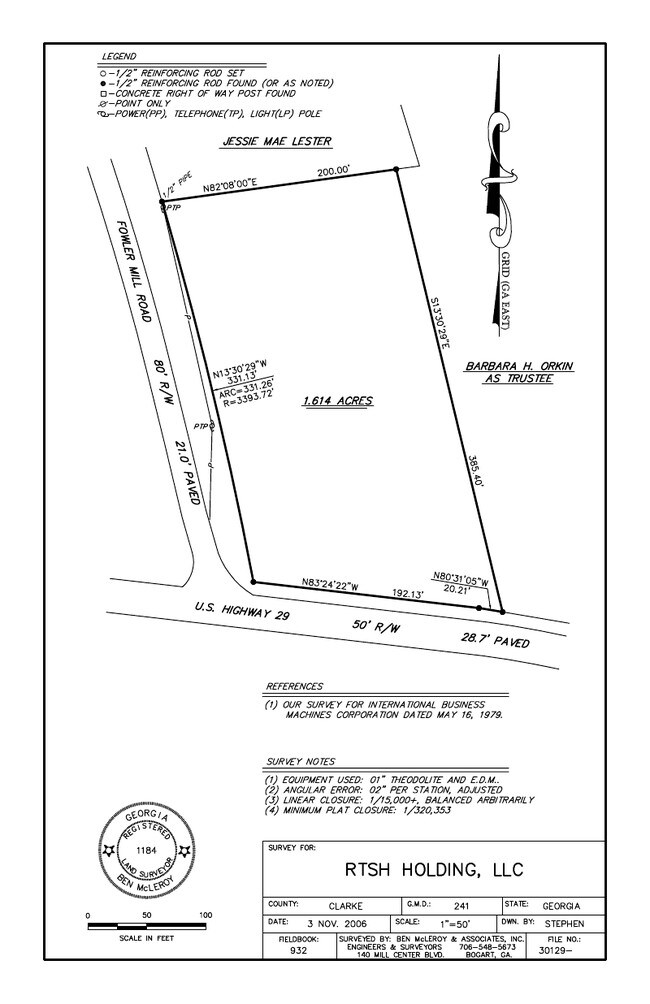
18.66 AC
13013C0175D
Westside Athens
1,618 SF
Other Market Areas
DEMOGRAPHICS near 5398 Atlanta Hwy
1 Mile
3 Mile
5 Mile
2024 Total Population
1,179
14,109
44,646
2029 Population
1,250
15,424
48,492
Pop Growth 2024-2029
+ 6.02%
+ 9.32%
+ 8.61%
Average Age
41
39
39
2024 Total Households
460
5,335
17,164
HH Growth 2024-2029
+ 5.65%
+ 8.68%
+ 7.81%
Median Household Inc
$69,211
$83,639
$74,121
Avg Household Size
2.60
2.60
2.60
2024 Avg HH Vehicles
2.00
2.00
2.00
Median Home Value
$253,649
$293,961
$297,835
Median Year Built
1987
2000
1997
Nearby Places
Map Layers
Map Styles
 Street
 Aerial
- Restaurants
- Banks
- Shops
- Fitness
- Groceries
SALE & LEASE HISTORY
LISTING DATE
SALE/LEASE

Sep 24, 2016
For Sale
Nearby Properties
Address
Land Use
TOTAL SIZE
Lot Size
Zoning
Address
Land Use
TOTAL SIZE
Lot Size
Zoning
317,646 SF
55.19 AC
AG
Address
Land Use
TOTAL SIZE
Lot Size
Zoning
1,020 SF
27.72 AC
RM-1
Address
Land Use
TOTAL SIZE
Lot Size
Zoning
1 SF
126.93 AC
E-I
Address
Land Use
TOTAL SIZE
Lot Size
Zoning
71,928 SF
10.59 AC
C-G
Address
Land Use
TOTAL SIZE
Lot Size
Zoning
24.99 AC
G
Address
Land Use
TOTAL SIZE
Lot Size
Zoning
425,000 SF
45.22 AC
I
Address
Land Use
TOTAL SIZE
Lot Size
Zoning
152,492 SF
6.49 AC
E-O
Address
Land Use
TOTAL SIZE
Lot Size
Zoning
137,764 SF
15.37 AC
C-G
Address
Land Use
TOTAL SIZE
Lot Size
Zoning
23,562 SF
30.09 AC
C-G
Address
Land Use
TOTAL SIZE
Lot Size
Zoning
38,380 SF
2.85 AC
C-O
Address
Land Use
TOTAL SIZE
Lot Size
Zoning
199.10 AC
RS-5
Address
Land Use
TOTAL SIZE
Lot Size
Zoning
10,570 SF
10 AC
C-G
Address
Land Use
TOTAL SIZE
Lot Size
Zoning
55,892 SF
4.34 AC
C-G
Address
Land Use
TOTAL SIZE
Lot Size
Zoning
1,200 SF
3.34 AC
C-G
Address
Land Use
TOTAL SIZE
Lot Size
Zoning
4,500 SF
6.06 AC
C-G
Address
Land Use
TOTAL SIZE
Lot Size
Zoning
1,032 SF
2.78 AC
RM-1
Address
Land Use
TOTAL SIZE
Lot Size
Zoning
2,979 SF
203.51 AC
I
Address
Land Use
TOTAL SIZE
Lot Size
Zoning
11,060 SF
5.42 AC
Address
Land Use
TOTAL SIZE
Lot Size
Zoning
33,727 SF
4.31 AC
C-G
Address
Land Use
TOTAL SIZE
Lot Size
Zoning
36,005 SF
4 AC
C-G
Address
Land Use
TOTAL SIZE
Lot Size
Zoning
99,600 SF
10.12 AC
001
Address
Land Use
TOTAL SIZE
Lot Size
Zoning
41,824 SF
1.35 AC
C-G
Address
Land Use
TOTAL SIZE
Lot Size
Zoning
30,918 SF
5.64 AC
C-G
Address
Land Use
TOTAL SIZE
Lot Size
Zoning
65,761 SF
5.05 AC
C-G
Address
Land Use
TOTAL SIZE
Lot Size
Zoning
22,478 SF
5.76 AC
O-I-P
Address
Land Use
TOTAL SIZE
Lot Size
Zoning
11,130 SF
32.08 AC
B-2
Address
Land Use
TOTAL SIZE
Lot Size
Zoning
147.09 AC
E-I
Address
Land Use
TOTAL SIZE
Lot Size
Zoning
Address
Land Use
TOTAL SIZE
Lot Size
Zoning
12,284 SF
8.36 AC
O-B-P
Address
Land Use
TOTAL SIZE
Lot Size
Zoning
36,000 SF
0.80 AC
The World's #1 Commercial Real Estate Marketplace
Connect with us
© 2025 CoStar Group
The information above has been obtained from sources believed reliable. While we do not doubt its accuracy we have not verified it and make no guarantee, warranty or representation about it. It is your responsibility to independently confirm its accuracy and completeness. Any projections, opinions, assumptions, or estimates used are for example only and do not represent the current or future performance of the property. The value of this transaction to you depends on tax and other factors which should be evaluated by your tax, financial, and legal advisors. You and your advisors should conduct a careful, independent investigation of the property to determine to your satisfaction the suitability of the property for your needs.