Property Record
Avalon Ct Dr, , NY
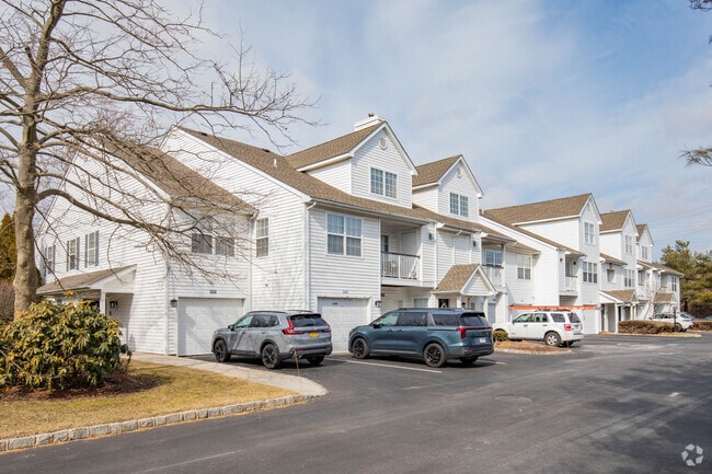

Property Detail
Avalon Ct Dr
Nassau County-Suffolk County, NY
AVALON COURT,APARTMENTS
0400-267-00-02-00-024-001
SUFFOLK
Apartment
New York
R40
24
B and X Area of moderate flood hazard, usually the area between the limits of the 100-year and 500-year floods.
11 AC
2024
Melville
2024
Long Island (New York)
112206
NEARBY LISTINGS FOR SALE OR LEASE
-
-
View all listings for sale on LoopNet.com
DEMOGRAPHICS near Avalon Ct Dr
1 mile
3 mile
5 mile
2024 Total Population
3,160
51,002
277,099
2029 Population
3,141
50,853
275,200
Pop Growth 2024-2029
(0.60%)
(0.29%)
(0.69%)
Average Age
49
44
42
2024 Total Households
1,281
17,839
89,991
HH Growth 2024-2029
(1.56%)
(0.30%)
(0.80%)
Median Household Inc
$121,626
$138,794
$141,200
Avg Household Size
2.10
2.70
2.90
2024 Avg HH Vehicles
1.00
2.00
2.00
Median Home Value
$711,467
$742,304
$689,991
Median Year Built
2005
1970
1959
Nearby Places
Map Layers
Map Styles
 Street
 Aerial
Transit
 Traffic
 Biking
Places
Listings with unknown addresses are not visible on the map
- Restaurants
- Banks
- Shops
- Fitness
- Groceries
PUBLIC TRANSPORTATION
COMMUTER RAIL
Pinelawn Station (Ronkonkoma Branch - Long Island Rail Road)
Drive
Walk
Distance
Pinelawn Station (Ronkonkoma Branch - Long Island Rail Road)
4 min
1.9 mi
Farmingdale Station (Ronkonkoma Branch - Long Island Rail Road)
Drive
Walk
Distance
Farmingdale Station (Ronkonkoma Branch - Long Island Rail Road)
6 min
2.8 mi
AIRPORT
Long Island MacArthur
Drive
Walk
Distance
Long Island MacArthur
31 min
19.5 mi
John F Kennedy International
Drive
Walk
Distance
John F Kennedy International
38 min
27.1 mi
LaGuardia
Drive
Walk
Distance
LaGuardia
45 min
29.8 mi
Freight Ports
NY - Red Hook Container Terminal
Drive
Walk
Distance
NY - Red Hook Container Terminal
56 min
37.9 mi
Nearby Properties
Address
Land Use
TOTAL SIZE
Lot Size
Zoning
Address
Land Use
TOTAL SIZE
Lot Size
Zoning
756 SF
0.36 AC
B1
Address
Land Use
TOTAL SIZE
Lot Size
Zoning
37 AC
I2
Address
Land Use
TOTAL SIZE
Lot Size
Zoning
3.31 AC
R40
Address
Land Use
TOTAL SIZE
Lot Size
Zoning
116,514 SF
382 AC
Address
Land Use
TOTAL SIZE
Lot Size
Zoning
35,978 SF
375.68 AC
Address
Land Use
TOTAL SIZE
Lot Size
Zoning
16,520 SF
160.33 AC
Address
Land Use
TOTAL SIZE
Lot Size
Zoning
1,945 SF
278.09 AC
Address
Land Use
TOTAL SIZE
Lot Size
Zoning
33.80 AC
Address
Land Use
TOTAL SIZE
Lot Size
Zoning
647,177 SF
51.88 AC
Address
Land Use
TOTAL SIZE
Lot Size
Zoning
77,270 SF
21.67 AC
Address
Land Use
TOTAL SIZE
Lot Size
Zoning
336,442 SF
43.50 AC
G
Address
Land Use
TOTAL SIZE
Lot Size
Zoning
288 SF
194.85 AC
Address
Land Use
TOTAL SIZE
Lot Size
Zoning
2,388 SF
0.36 AC
B1
Address
Land Use
TOTAL SIZE
Lot Size
Zoning
3,951 SF
44.33 AC
Address
Land Use
TOTAL SIZE
Lot Size
Zoning
52.10 AC
Address
Land Use
TOTAL SIZE
Lot Size
Zoning
52,750 SF
55.67 AC
Address
Land Use
TOTAL SIZE
Lot Size
Zoning
37.20 AC
I2
Address
Land Use
TOTAL SIZE
Lot Size
Zoning
24.75 AC
R40
Address
Land Use
TOTAL SIZE
Lot Size
Zoning
183.15 AC
Address
Land Use
TOTAL SIZE
Lot Size
Zoning
1,680 SF
0.15 AC
B1
Address
Land Use
TOTAL SIZE
Lot Size
Zoning
11.50 AC
C10
Address
Land Use
TOTAL SIZE
Lot Size
Zoning
2.92 AC
R20
Address
Land Use
TOTAL SIZE
Lot Size
Zoning
12 AC
I1
Address
Land Use
TOTAL SIZE
Lot Size
Zoning
22.20 AC
I1
Address
Land Use
TOTAL SIZE
Lot Size
Zoning
14.40 AC
I1
Address
Land Use
TOTAL SIZE
Lot Size
Zoning
74.90 AC
G
Address
Land Use
TOTAL SIZE
Lot Size
Zoning
157,191 SF
17.70 AC
G
Address
Land Use
TOTAL SIZE
Lot Size
Zoning
114.70 AC
A
Address
Land Use
TOTAL SIZE
Lot Size
Zoning
292.40 AC
A
Address
Land Use
TOTAL SIZE
Lot Size
Zoning
0.26 AC
R20
The World's #1 Commercial Real Estate Marketplace
Connect with us
© 2026 CoStar Group
The information above has been obtained from sources believed reliable. While we do not doubt its accuracy we have not verified it and make no guarantee, warranty or representation about it. It is your responsibility to independently confirm its accuracy and completeness. Any projections, opinions, assumptions, or estimates used are for example only and do not represent the current or future performance of the property. The value of this transaction to you depends on tax and other factors which should be evaluated by your tax, financial, and legal advisors. You and your advisors should conduct a careful, independent investigation of the property to determine to your satisfaction the suitability of the property for your needs.