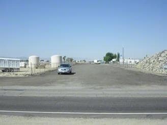
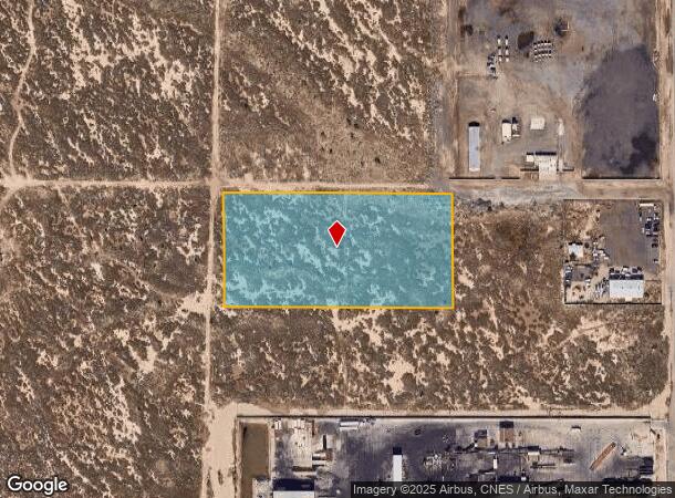
Property Record
Vac Vic Division St Avenue H, Lancaster, CA 93535
NEARBY LISTINGS FOR SALE OR LEASE
Property Detail
Vac Vic Division St Avenue H
Los Angeles-Long Beach-Glendale, CA
5 MORE OR LESS ACS N 1/2 OF NW 1/4 OF SE 1/4 OF SE 1/4 OF SEC 3 T 7N R 12W
3137-008-051
Los Angeles
Industrialacreage
California
X
3
06037C0410F
5.07 AC
2024
Antelope Valley
2025
Los Angeles
900508
DEMOGRAPHICS near Vac Vic Division St Avenue H
1 Mile
3 Mile
5 Mile
2024 Total Population
2,372
64,074
140,069
2029 Population
2,283
62,178
135,983
Pop Growth 2024-2029
(3.75%)
(2.96%)
(2.92%)
Average Age
35
36
36
2024 Total Households
667
19,607
44,204
HH Growth 2024-2029
(3.90%)
(3.17%)
(3.09%)
Median Household Inc
$49,765
$47,128
$55,599
Avg Household Size
3.40
3.10
3.00
2024 Avg HH Vehicles
2.00
2.00
2.00
Median Home Value
$219,286
$220,759
$280,895
Median Year Built
1977
1979
1983
Nearby Places
- Restaurants
- Banks
- Shops
- Fitness
- Groceries
PUBLIC TRANSPORTATION
COMMUTER RAIL
Lancaster (Antelope Valley Line - Southern California Regional Rail Authority (Metrolink))
DRIVE
WALK
Distance
Lancaster (Antelope Valley Line - Southern California Regional Rail Authority (Metrolink))
5 min
2.3 mi
Palmdale (Antelope Valley Line - Southern California Regional Rail Authority (Metrolink))
DRIVE
WALK
Distance
Palmdale (Antelope Valley Line - Southern California Regional Rail Authority (Metrolink))
18 min
10.0 mi
Freight Ports
Port of Long Beach
DRIVE
WALK
Distance
Port of Long Beach
115 min
97.9 mi
Nearby Properties
Address
Land Use
TOTAL SIZE
Lot Size
Zoning
Address
Land Use
TOTAL SIZE
Lot Size
Zoning
2,922,905 SF
85.01 AC
LRLI
Address
Land Use
TOTAL SIZE
Lot Size
Zoning
153,117 SF
14.12 AC
LRSP80-01*
Address
Land Use
TOTAL SIZE
Lot Size
Zoning
552,178 SF
17.77 AC
LRHI*
Address
Land Use
TOTAL SIZE
Lot Size
Zoning
212,198 SF
18.27 AC
LRSP80-01*
Address
Land Use
TOTAL SIZE
Lot Size
Zoning
185,527 SF
9.65 AC
LRR325U*
Address
Land Use
TOTAL SIZE
Lot Size
Zoning
876,730 SF
20.85 AC
LRCP
Address
Land Use
TOTAL SIZE
Lot Size
Zoning
214,178 SF
13.95 AC
LRRA7000*
Address
Land Use
TOTAL SIZE
Lot Size
Zoning
145,593 SF
5.18 AC
LRC3*
Address
Land Use
TOTAL SIZE
Lot Size
Zoning
76,093 SF
1.37 AC
LRC3*
Address
Land Use
TOTAL SIZE
Lot Size
Zoning
73,248 SF
3.56 AC
LRR325UDP*
Address
Land Use
TOTAL SIZE
Lot Size
Zoning
70,456 SF
3.05 AC
LRRC
Address
Land Use
TOTAL SIZE
Lot Size
Zoning
81,668 SF
5.47 AC
LRSP80-01*
Address
Land Use
TOTAL SIZE
Lot Size
Zoning
137,190 SF
11.24 AC
LRSP80-01*
Address
Land Use
TOTAL SIZE
Lot Size
Zoning
51,233 SF
3.22 AC
LRC3*
Address
Land Use
TOTAL SIZE
Lot Size
Zoning
71,300 SF
5.25 AC
LRMDRZ*
Address
Land Use
TOTAL SIZE
Lot Size
Zoning
52,659 SF
2.16 AC
LRRC
Address
Land Use
TOTAL SIZE
Lot Size
Zoning
49,891 SF
1.62 AC
LRC3*
Address
Land Use
TOTAL SIZE
Lot Size
Zoning
113,960 SF
9 AC
LRD21*
Address
Land Use
TOTAL SIZE
Lot Size
Zoning
106,485 SF
1.09 AC
LRC3*
Address
Land Use
TOTAL SIZE
Lot Size
Zoning
70,936 SF
3.20 AC
LRCPD*
Address
Land Use
TOTAL SIZE
Lot Size
Zoning
667,949 SF
10.68 AC
LRXP
Address
Land Use
TOTAL SIZE
Lot Size
Zoning
582,222 SF
12.61 AC
LRCPD
Address
Land Use
TOTAL SIZE
Lot Size
Zoning
52,478 SF
5.07 AC
LRCPD
Address
Land Use
TOTAL SIZE
Lot Size
Zoning
Address
Land Use
TOTAL SIZE
Lot Size
Zoning
75,508 SF
6.14 AC
LRCPD*
Address
Land Use
TOTAL SIZE
Lot Size
Zoning
105,700 SF
7.06 AC
LRCPD*
Address
Land Use
TOTAL SIZE
Lot Size
Zoning
15,125 SF
1.31 AC
LRC3*
Address
Land Use
TOTAL SIZE
Lot Size
Zoning
41,162 SF
2.91 AC
LRC3-B1*
Address
Land Use
TOTAL SIZE
Lot Size
Zoning
83,194 SF
5.82 AC
LRSP80-03*
The World's #1 Commercial Real Estate Marketplace
Connect with us
© 2025 CoStar Group
The information above has been obtained from sources believed reliable. While we do not doubt its accuracy we have not verified it and make no guarantee, warranty or representation about it. It is your responsibility to independently confirm its accuracy and completeness. Any projections, opinions, assumptions, or estimates used are for example only and do not represent the current or future performance of the property. The value of this transaction to you depends on tax and other factors which should be evaluated by your tax, financial, and legal advisors. You and your advisors should conduct a careful, independent investigation of the property to determine to your satisfaction the suitability of the property for your needs.