Property Record
B Moore Rd, Winter Haven, FL 33881
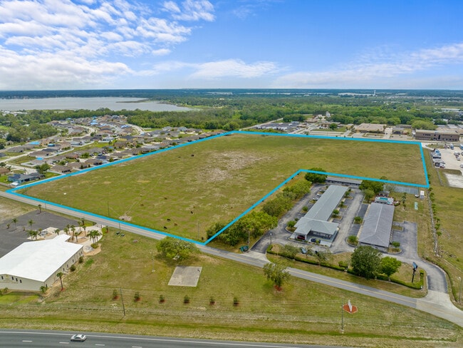
This Property Is For Sale
Property Detail
B Moore Rd
Lakeland-Winter Haven, FL
COMM AT SW COR OF N1/2 OF S1/2 OF NW1/4 OF SE1/4 RUN E 30 FT N 79.86 FT FOR POB E 1267.36 FT ALONG LINE PARALLEL WITH AND 912.35 FT S OF N BDRY OF SE1/4 TO PT ON W R/W OF B MOORE RD N 372.87 FT ALONG R/W W 1269.12 FT TO PT ON E R/W LINE S 372.87 FT A
27-28-06-000000-014050
POLK
Pasture
Florida
B and X Area of moderate flood hazard, usually the area between the limits of the 100-year and 500-year floods.
10.85 AC
2024
Polk County
2025
Tampa/St Petersburg
013602
NEARBY LISTINGS FOR SALE OR LEASE
DEMOGRAPHICS near B Moore Rd
1 mile
3 mile
5 mile
2025 Total Population
3,449
31,114
93,305
2030 Population
4,047
36,285
108,326
Pop Growth 2025-2030
+ 17.34%
+ 16.62%
+ 16.10%
Average Age
49
45
41
2025 Total Households
1,505
12,322
34,921
HH Growth 2025-2030
+ 17.74%
+ 16.82%
+ 16.33%
Median Household Inc
$55,314
$59,777
$62,832
Avg Household Size
2.30
2.50
2.60
2025 Avg HH Vehicles
1.00
2.00
2.00
Median Home Value
$243,055
$223,998
$267,311
Median Year Built
1984
1993
1996
Nearby Places
Map Layers
Map Styles
 Street
 Aerial
Transit
 Traffic
 Biking
Places
Listings with unknown addresses are not visible on the map
- Restaurants
- Banks
- Shops
- Fitness
- Groceries
PUBLIC TRANSPORTATION
COMMUTER RAIL
Winter Haven (Silver Meteor - Amtrak, Silver Star - Amtrak)
Drive
Walk
Distance
Winter Haven (Silver Meteor - Amtrak, Silver Star - Amtrak)
18 min
10.0 mi
Freight Ports
Port of Tampa Bay
Drive
Walk
Distance
Port of Tampa Bay
81 min
55.1 mi
Nearby Properties
Address
Land Use
TOTAL SIZE
Lot Size
Zoning
Address
Land Use
TOTAL SIZE
Lot Size
Zoning
807,937 SF
72.45 AC
Address
Land Use
TOTAL SIZE
Lot Size
Zoning
919,224 SF
103.84 AC
IM
Address
Land Use
TOTAL SIZE
Lot Size
Zoning
386,137 SF
39.91 AC
Address
Land Use
TOTAL SIZE
Lot Size
Zoning
200,070 SF
19.09 AC
Address
Land Use
TOTAL SIZE
Lot Size
Zoning
154,429 SF
51.75 AC
Address
Land Use
TOTAL SIZE
Lot Size
Zoning
175,423 SF
47.09 AC
XX
Address
Land Use
TOTAL SIZE
Lot Size
Zoning
200,000 SF
22.75 AC
Address
Land Use
TOTAL SIZE
Lot Size
Zoning
379,597 SF
40.77 AC
OUA
Address
Land Use
TOTAL SIZE
Lot Size
Zoning
181,804 SF
52.32 AC
XX
Address
Land Use
TOTAL SIZE
Lot Size
Zoning
127,559 SF
9.87 AC
Address
Land Use
TOTAL SIZE
Lot Size
Zoning
92,502 SF
15.22 AC
Address
Land Use
TOTAL SIZE
Lot Size
Zoning
96,370 SF
5.08 AC
Address
Land Use
TOTAL SIZE
Lot Size
Zoning
78,344 SF
17.46 AC
Address
Land Use
TOTAL SIZE
Lot Size
Zoning
40,156 SF
13.54 AC
R3
Address
Land Use
TOTAL SIZE
Lot Size
Zoning
147,825 SF
10.23 AC
Address
Land Use
TOTAL SIZE
Lot Size
Zoning
94,518 SF
43.26 AC
Address
Land Use
TOTAL SIZE
Lot Size
Zoning
72,928 SF
4.73 AC
Address
Land Use
TOTAL SIZE
Lot Size
Zoning
85,890 SF
7.75 AC
C1
Address
Land Use
TOTAL SIZE
Lot Size
Zoning
100,910 SF
12.49 AC
ILW
Address
Land Use
TOTAL SIZE
Lot Size
Zoning
37,176 SF
15.29 AC
Address
Land Use
TOTAL SIZE
Lot Size
Zoning
28,850 SF
12.62 AC
Address
Land Use
TOTAL SIZE
Lot Size
Zoning
86,942 SF
20 AC
Address
Land Use
TOTAL SIZE
Lot Size
Zoning
21,510 SF
29 AC
RC
Address
Land Use
TOTAL SIZE
Lot Size
Zoning
186,101 SF
10.97 AC
R3
Address
Land Use
TOTAL SIZE
Lot Size
Zoning
179,084 SF
7.92 AC
IH
Address
Land Use
TOTAL SIZE
Lot Size
Zoning
75,054 SF
5.44 AC
Address
Land Use
TOTAL SIZE
Lot Size
Zoning
34,063 SF
21.84 AC
R1A
Address
Land Use
TOTAL SIZE
Lot Size
Zoning
17,441 SF
119.40 AC
RC
Address
Land Use
TOTAL SIZE
Lot Size
Zoning
44,752 SF
4.40 AC
R3
Address
Land Use
TOTAL SIZE
Lot Size
Zoning
107,850 SF
15.16 AC
The World's #1 Commercial Real Estate Marketplace
Connect with us
© 2026 CoStar Group
The information above has been obtained from sources believed reliable. While we do not doubt its accuracy we have not verified it and make no guarantee, warranty or representation about it. It is your responsibility to independently confirm its accuracy and completeness. Any projections, opinions, assumptions, or estimates used are for example only and do not represent the current or future performance of the property. The value of this transaction to you depends on tax and other factors which should be evaluated by your tax, financial, and legal advisors. You and your advisors should conduct a careful, independent investigation of the property to determine to your satisfaction the suitability of the property for your needs.