Property Record
Bailey Rd, Pearland, TX 77486

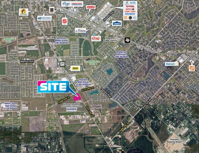
Current Lease Availabilities
Property Detail
Bailey Rd
Houston-Pasadena-The Woodlands, TX
STRIPES PEARLAND (A0507 ACH&B) BLK 1 LOT 2 ACRES 3.3256
7826-0001-002
BRAZORIA
Agriculturalland
Texas
B and X Area of moderate flood hazard, usually the area between the limits of the 100-year and 500-year floods.
2
2024
3.33 AC
2025
South
660701
Houston
NEARBY LISTINGS FOR SALE OR LEASE
DEMOGRAPHICS near Bailey Rd
1 mile
3 mile
5 mile
2025 Total Population
5,355
56,842
149,048
2030 Population
5,830
61,995
160,037
Pop Growth 2025-2030
+ 8.87%
+ 9.07%
+ 7.37%
Average Age
37
38
38
2025 Total Households
1,727
19,364
49,764
HH Growth 2025-2030
+ 9.21%
+ 9.31%
+ 7.56%
Median Household Inc
$144,254
$114,039
$107,793
Avg Household Size
3.10
2.90
2.90
2025 Avg HH Vehicles
2.00
2.00
2.00
Median Home Value
$369,919
$341,412
$323,993
Median Year Built
2005
1997
1996
Nearby Places
Map Layers
Map Styles
 Street
 Aerial
Transit
 Traffic
 Biking
Places
Listings with unknown addresses are not visible on the map
- Restaurants
- Banks
- Shops
- Fitness
- Groceries
PUBLIC TRANSPORTATION
AIRPORT
William P Hobby
Drive
Walk
Distance
William P Hobby
17 min
8.2 mi
Freight Ports
Port of Houston
Drive
Walk
Distance
Port of Houston
28 min
16.4 mi
Nearby Properties
Address
Land Use
TOTAL SIZE
Lot Size
Zoning
Address
Land Use
TOTAL SIZE
Lot Size
Zoning
40.52 AC
0017
Address
Land Use
TOTAL SIZE
Lot Size
Zoning
83.37 AC
0004
Address
Land Use
TOTAL SIZE
Lot Size
Zoning
64.56 AC
0016
Address
Land Use
TOTAL SIZE
Lot Size
Zoning
236,642 SF
11.48 AC
Address
Land Use
TOTAL SIZE
Lot Size
Zoning
7.42 AC
Address
Land Use
TOTAL SIZE
Lot Size
Zoning
128,754 SF
14.83 AC
Address
Land Use
TOTAL SIZE
Lot Size
Zoning
97,736 SF
16.49 AC
Address
Land Use
TOTAL SIZE
Lot Size
Zoning
14.93 AC
Address
Land Use
TOTAL SIZE
Lot Size
Zoning
144,879 SF
8.91 AC
Address
Land Use
TOTAL SIZE
Lot Size
Zoning
110,990 SF
18.25 AC
Address
Land Use
TOTAL SIZE
Lot Size
Zoning
89.23 AC
Address
Land Use
TOTAL SIZE
Lot Size
Zoning
155,524 SF
7.86 AC
Address
Land Use
TOTAL SIZE
Lot Size
Zoning
113,376 SF
9.80 AC
Address
Land Use
TOTAL SIZE
Lot Size
Zoning
148,902 SF
11.40 AC
Address
Land Use
TOTAL SIZE
Lot Size
Zoning
114,828 SF
7.94 AC
Address
Land Use
TOTAL SIZE
Lot Size
Zoning
134,596 SF
7.21 AC
Address
Land Use
TOTAL SIZE
Lot Size
Zoning
221,377 SF
26.83 AC
Address
Land Use
TOTAL SIZE
Lot Size
Zoning
229,097 SF
22.66 AC
Address
Land Use
TOTAL SIZE
Lot Size
Zoning
67,595 SF
4.97 AC
Address
Land Use
TOTAL SIZE
Lot Size
Zoning
106,341 SF
12.12 AC
0550
Address
Land Use
TOTAL SIZE
Lot Size
Zoning
54,802 SF
12.63 AC
0014
Address
Land Use
TOTAL SIZE
Lot Size
Zoning
49.29 AC
0007
Address
Land Use
TOTAL SIZE
Lot Size
Zoning
80,715 SF
8.73 AC
Address
Land Use
TOTAL SIZE
Lot Size
Zoning
129,025 SF
7.02 AC
Address
Land Use
TOTAL SIZE
Lot Size
Zoning
63,615 SF
6.42 AC
0010
Address
Land Use
TOTAL SIZE
Lot Size
Zoning
6,948 SF
54.94 AC
2080
Address
Land Use
TOTAL SIZE
Lot Size
Zoning
86,550 SF
8.45 AC
Address
Land Use
TOTAL SIZE
Lot Size
Zoning
19.61 AC
Address
Land Use
TOTAL SIZE
Lot Size
Zoning
95,592 SF
5.93 AC
Address
Land Use
TOTAL SIZE
Lot Size
Zoning
151,863 SF
15.04 AC
The World's #1 Commercial Real Estate Marketplace
Connect with us
© 2026 CoStar Group
The information above has been obtained from sources believed reliable. While we do not doubt its accuracy we have not verified it and make no guarantee, warranty or representation about it. It is your responsibility to independently confirm its accuracy and completeness. Any projections, opinions, assumptions, or estimates used are for example only and do not represent the current or future performance of the property. The value of this transaction to you depends on tax and other factors which should be evaluated by your tax, financial, and legal advisors. You and your advisors should conduct a careful, independent investigation of the property to determine to your satisfaction the suitability of the property for your needs.