Property Record
Bankston Rd, Hammond, LA 70403


Property Detail
Bankston Rd
Hammond, LA
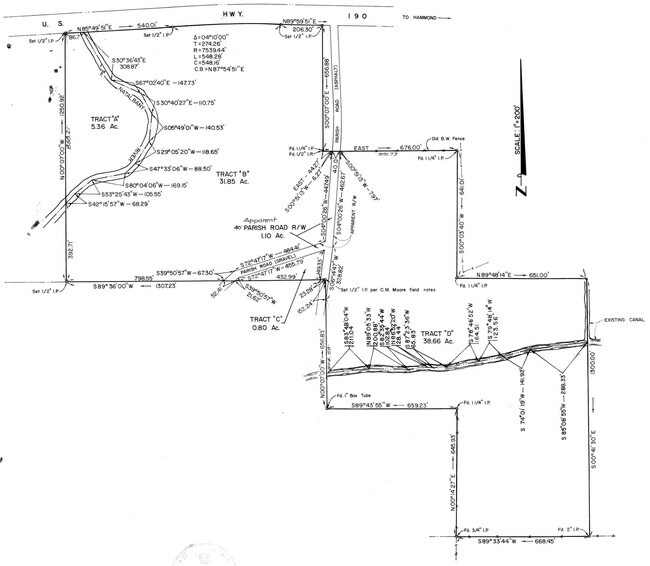
80.41A IN SEC 30 T6SR7E B477 P720 B537 P660 B543 P450 B1172 P897 B1200 P613 B1332 P142-144-146 MAP 537660
03750108
TANGIPAHOA
Timberlandforesttreesagricultural
Louisiana
B and X Area of moderate flood hazard, usually the area between the limits of the 100-year and 500-year floods.
80.41 AC
2025
Louisiana South Area
2025
Other Market Areas
954503
NEARBY LISTINGS FOR SALE OR LEASE
DEMOGRAPHICS near Bankston Rd
1 mile
3 mile
5 mile
2025 Total Population
1,798
16,670
48,730
2030 Population
1,875
17,240
50,476
Pop Growth 2025-2030
+ 4.28%
+ 3.42%
+ 3.58%
Average Age
38
38
37
2025 Total Households
720
6,456
18,547
HH Growth 2025-2030
+ 4.44%
+ 3.61%
+ 3.80%
Median Household Inc
$39,832
$52,779
$51,988
Avg Household Size
2.50
2.50
2.50
2025 Avg HH Vehicles
2.00
2.00
2.00
Median Home Value
$199,291
$221,342
$220,561
Median Year Built
1988
1991
1991
Nearby Places
Map Layers
Map Styles
 Street
 Aerial
Layers
 Traffic
 Biking
Places
Listings with unknown addresses are not visible on the map
- Restaurants
- Banks
- Shops
- Fitness
- Groceries
PUBLIC TRANSPORTATION
COMMUTER RAIL
Hammond Amtrak Station (City of New Orleans - Amtrak)
Drive
Walk
Distance
Hammond Amtrak Station (City of New Orleans - Amtrak)
9 min
4.9 mi
Freight Ports
Port of Greater Baton Rouge
Drive
Walk
Distance
Port of Greater Baton Rouge
55 min
44.3 mi
Nearby Properties
Address
Land Use
TOTAL SIZE
Lot Size
Zoning
Address
Land Use
TOTAL SIZE
Lot Size
Zoning
Address
Land Use
TOTAL SIZE
Lot Size
Zoning
1,071,740 SF
67.96 AC
Address
Land Use
TOTAL SIZE
Lot Size
Zoning
Address
Land Use
TOTAL SIZE
Lot Size
Zoning
29.69 AC
Address
Land Use
TOTAL SIZE
Lot Size
Zoning
199,026 SF
33 AC
Address
Land Use
TOTAL SIZE
Lot Size
Zoning
10.50 AC
Address
Land Use
TOTAL SIZE
Lot Size
Zoning
28.50 AC
Address
Land Use
TOTAL SIZE
Lot Size
Zoning
135,524 SF
31.08 AC
Address
Land Use
TOTAL SIZE
Lot Size
Zoning
31,920 SF
23.68 AC
Address
Land Use
TOTAL SIZE
Lot Size
Zoning
37.32 AC
Address
Land Use
TOTAL SIZE
Lot Size
Zoning
19,845 SF
10 AC
Address
Land Use
TOTAL SIZE
Lot Size
Zoning
35,992 SF
1.99 AC
Address
Land Use
TOTAL SIZE
Lot Size
Zoning
96,994 SF
4.21 AC
Address
Land Use
TOTAL SIZE
Lot Size
Zoning
41,857 SF
16 AC
Address
Land Use
TOTAL SIZE
Lot Size
Zoning
22,062 SF
2.89 AC
Address
Land Use
TOTAL SIZE
Lot Size
Zoning
9,999 SF
1 AC
Address
Land Use
TOTAL SIZE
Lot Size
Zoning
44,320 SF
44.78 AC
Address
Land Use
TOTAL SIZE
Lot Size
Zoning
27,999 SF
0.83 AC
Address
Land Use
TOTAL SIZE
Lot Size
Zoning
49,610 SF
1.84 AC
Address
Land Use
TOTAL SIZE
Lot Size
Zoning
23,085 SF
1.59 AC
Address
Land Use
TOTAL SIZE
Lot Size
Zoning
1,025 SF
1.21 AC
Address
Land Use
TOTAL SIZE
Lot Size
Zoning
38,780 SF
8.55 AC
Address
Land Use
TOTAL SIZE
Lot Size
Zoning
16,796 SF
1.99 AC
Address
Land Use
TOTAL SIZE
Lot Size
Zoning
12,450 SF
5.32 AC
Address
Land Use
TOTAL SIZE
Lot Size
Zoning
Address
Land Use
TOTAL SIZE
Lot Size
Zoning
1.39 AC
Address
Land Use
TOTAL SIZE
Lot Size
Zoning
Address
Land Use
TOTAL SIZE
Lot Size
Zoning
16,547 SF
3.92 AC
Address
Land Use
TOTAL SIZE
Lot Size
Zoning
22,948 SF
8.79 AC
Address
Land Use
TOTAL SIZE
Lot Size
Zoning
The World's #1 Commercial Real Estate Marketplace
Connect with us
© 2026 CoStar Group
The information above has been obtained from sources believed reliable. While we do not doubt its accuracy we have not verified it and make no guarantee, warranty or representation about it. It is your responsibility to independently confirm its accuracy and completeness. Any projections, opinions, assumptions, or estimates used are for example only and do not represent the current or future performance of the property. The value of this transaction to you depends on tax and other factors which should be evaluated by your tax, financial, and legal advisors. You and your advisors should conduct a careful, independent investigation of the property to determine to your satisfaction the suitability of the property for your needs.