Property Record
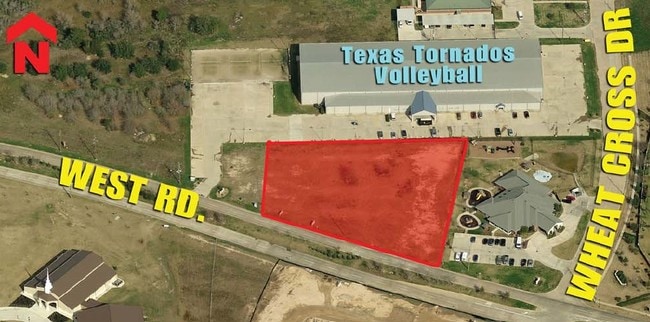
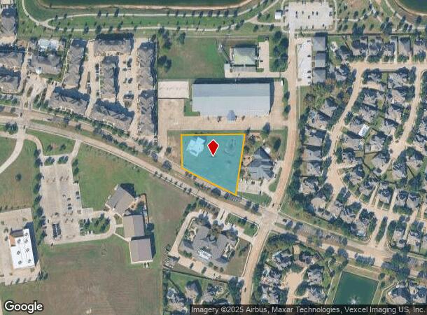
17820 West Rd, Houston, TX 77095
NEARBY LISTINGS FOR SALE OR LEASE
Property Detail
17820 West Rd
1257530010003
Tornados Volleyball
Commercialnec
RES C BLK 1 TORNADOS VOLLEYBALL
X
Harris
48201C0420P
Texas
2024
1.52 AC
2025
FM 1960/Hwy 249
541100
Houston
4,972 SF
Houston-The Woodlands-Sugar Land, TX
DEMOGRAPHICS near 17820 West Rd
1 Mile
3 Mile
5 Mile
2024 Total Population
13,177
130,258
313,871
2029 Population
13,284
132,104
319,002
Pop Growth 2024-2029
+ 0.81%
+ 1.42%
+ 1.63%
Average Age
38
36
36
2024 Total Households
4,430
40,761
100,151
HH Growth 2024-2029
+ 0.81%
+ 1.32%
+ 1.55%
Median Household Inc
$117,881
$95,764
$89,455
Avg Household Size
3.00
3.10
3.10
2024 Avg HH Vehicles
2.00
2.00
2.00
Median Home Value
$307,262
$262,835
$247,351
Median Year Built
2006
2003
2002
Nearby Places
Map Layers
Map Styles
 Street
 Aerial
- Restaurants
- Banks
- Shops
- Fitness
- Groceries
PUBLIC TRANSPORTATION
AIRPORT
George Bush Intcntl/Houston
DRIVE
WALK
Distance
George Bush Intcntl/Houston
37 min
25.4 mi
Freight Ports
Port of Houston
DRIVE
WALK
Distance
Port of Houston
50 min
33.4 mi
SALE & LEASE HISTORY
LISTING DATE
SALE/LEASE

Sep 24, 2016
For Sale
Nearby Properties
Address
Land Use
TOTAL SIZE
Lot Size
Zoning
Address
Land Use
TOTAL SIZE
Lot Size
Zoning
483,699 SF
13 AC
Address
Land Use
TOTAL SIZE
Lot Size
Zoning
697,158 SF
Address
Land Use
TOTAL SIZE
Lot Size
Zoning
560,725 SF
31.41 AC
Address
Land Use
TOTAL SIZE
Lot Size
Zoning
355,721 SF
13 AC
Address
Land Use
TOTAL SIZE
Lot Size
Zoning
373,285 SF
13.32 AC
Address
Land Use
TOTAL SIZE
Lot Size
Zoning
1,353,057 SF
224.60 AC
Address
Land Use
TOTAL SIZE
Lot Size
Zoning
379,588 SF
12.06 AC
Address
Land Use
TOTAL SIZE
Lot Size
Zoning
351,997 SF
13.28 AC
Address
Land Use
TOTAL SIZE
Lot Size
Zoning
365,784 SF
12.87 AC
Address
Land Use
TOTAL SIZE
Lot Size
Zoning
307,960 SF
31.75 AC
Address
Land Use
TOTAL SIZE
Lot Size
Zoning
363,605 SF
13.77 AC
Address
Land Use
TOTAL SIZE
Lot Size
Zoning
55.82 AC
Address
Land Use
TOTAL SIZE
Lot Size
Zoning
418,572 SF
24.76 AC
Address
Land Use
TOTAL SIZE
Lot Size
Zoning
399,729 SF
20.15 AC
Address
Land Use
TOTAL SIZE
Lot Size
Zoning
401,107 SF
33.90 AC
Address
Land Use
TOTAL SIZE
Lot Size
Zoning
388,223 SF
14.99 AC
Address
Land Use
TOTAL SIZE
Lot Size
Zoning
290,927 SF
14.53 AC
Address
Land Use
TOTAL SIZE
Lot Size
Zoning
301,102 SF
12.58 AC
Address
Land Use
TOTAL SIZE
Lot Size
Zoning
342,196 SF
15.13 AC
Address
Land Use
TOTAL SIZE
Lot Size
Zoning
97,084 SF
2.09 AC
Address
Land Use
TOTAL SIZE
Lot Size
Zoning
191,673 SF
7.29 AC
Address
Land Use
TOTAL SIZE
Lot Size
Zoning
243,919 SF
11.75 AC
Address
Land Use
TOTAL SIZE
Lot Size
Zoning
186,161 SF
8.65 AC
Address
Land Use
TOTAL SIZE
Lot Size
Zoning
230,425 SF
11.49 AC
Address
Land Use
TOTAL SIZE
Lot Size
Zoning
222,256 SF
21.39 AC
Address
Land Use
TOTAL SIZE
Lot Size
Zoning
279,000 SF
4.30 AC
Address
Land Use
TOTAL SIZE
Lot Size
Zoning
230,301 SF
14.24 AC
Address
Land Use
TOTAL SIZE
Lot Size
Zoning
147,900 SF
5.76 AC
Address
Land Use
TOTAL SIZE
Lot Size
Zoning
226,200 SF
13.96 AC
Address
Land Use
TOTAL SIZE
Lot Size
Zoning
150,570 SF
18.16 AC
The World's #1 Commercial Real Estate Marketplace
Connect with us
© 2025 CoStar Group
The information above has been obtained from sources believed reliable. While we do not doubt its accuracy we have not verified it and make no guarantee, warranty or representation about it. It is your responsibility to independently confirm its accuracy and completeness. Any projections, opinions, assumptions, or estimates used are for example only and do not represent the current or future performance of the property. The value of this transaction to you depends on tax and other factors which should be evaluated by your tax, financial, and legal advisors. You and your advisors should conduct a careful, independent investigation of the property to determine to your satisfaction the suitability of the property for your needs.