Property Record
Barksdale Blvd, , LA
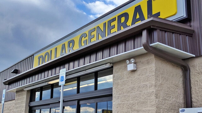

Property Detail
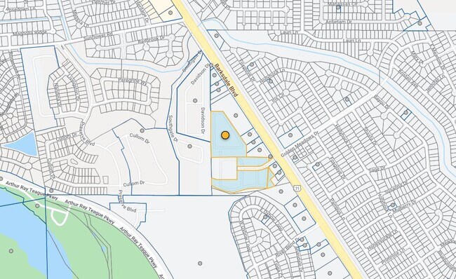
Barksdale Blvd
Shreveport-Bossier City, LA
BEGIN AT NE CORNER OF LOT 56, EAGLE BEND POINT #1 (SAID CORNER ALSO BEING ON THE SLY R/W OF RIVER BEND DR), THENCE ALONG SLY
204846
BOSSIER
Storebuilding
Louisiana
2025
56
2025
Bossier Parish
8,887 SF
Shreveport/Bossier City
NEARBY LISTINGS FOR SALE OR LEASE
DEMOGRAPHICS near Barksdale Blvd
1 mile
3 mile
5 mile
2025 Total Population
6,352
20,115
61,417
2030 Population
6,385
20,022
60,367
Pop Growth 2025-2030
+ 0.52%
(0.46%)
(1.71%)
Average Age
40
40
40
2025 Total Households
2,469
8,226
26,825
HH Growth 2025-2030
+ 0.69%
(0.53%)
(1.81%)
Median Household Inc
$78,125
$81,299
$72,639
Avg Household Size
2.60
2.40
2.20
2025 Avg HH Vehicles
2.00
2.00
2.00
Median Home Value
$239,780
$222,710
$213,388
Median Year Built
1994
1990
1980
Nearby Places
Map Layers
Map Styles
 Street
 Aerial
Layers
 Traffic
 Biking
Places
Listings with unknown addresses are not visible on the map
- Restaurants
- Banks
- Shops
- Fitness
- Groceries
PUBLIC TRANSPORTATION
AIRPORT
Shreveport Regional
Drive
Walk
Distance
Shreveport Regional
24 min
11.7 mi
Freight Ports
Port of Shreveport
Drive
Walk
Distance
Port of Shreveport
21 min
13.1 mi
SALE & LEASE HISTORY
LISTING DATE
SALE/LEASE

Apr 08, 2021
For Sale
Nearby Properties
Address
Land Use
TOTAL SIZE
Lot Size
Zoning
Address
Land Use
TOTAL SIZE
Lot Size
Zoning
188,163 SF
38 AC
Address
Land Use
TOTAL SIZE
Lot Size
Zoning
87,478 SF
2.95 AC
Address
Land Use
TOTAL SIZE
Lot Size
Zoning
37,500 SF
28.66 AC
Address
Land Use
TOTAL SIZE
Lot Size
Zoning
49,733 SF
4 AC
Address
Land Use
TOTAL SIZE
Lot Size
Zoning
36,384 SF
3.21 AC
Address
Land Use
TOTAL SIZE
Lot Size
Zoning
49,636 SF
5 AC
Address
Land Use
TOTAL SIZE
Lot Size
Zoning
43,490 SF
7.87 AC
Address
Land Use
TOTAL SIZE
Lot Size
Zoning
60,339 SF
15 AC
Address
Land Use
TOTAL SIZE
Lot Size
Zoning
28,500 SF
12 AC
Address
Land Use
TOTAL SIZE
Lot Size
Zoning
20,520 SF
7.06 AC
Address
Land Use
TOTAL SIZE
Lot Size
Zoning
63,150 SF
5 AC
Address
Land Use
TOTAL SIZE
Lot Size
Zoning
100 SF
1.20 AC
Address
Land Use
TOTAL SIZE
Lot Size
Zoning
36,154 SF
1 AC
Address
Land Use
TOTAL SIZE
Lot Size
Zoning
100 SF
9.95 AC
Address
Land Use
TOTAL SIZE
Lot Size
Zoning
50,407 SF
3.82 AC
Address
Land Use
TOTAL SIZE
Lot Size
Zoning
9,075 SF
10 AC
Address
Land Use
TOTAL SIZE
Lot Size
Zoning
19,380 SF
0.76 AC
Address
Land Use
TOTAL SIZE
Lot Size
Zoning
11,348 SF
4.26 AC
Address
Land Use
TOTAL SIZE
Lot Size
Zoning
22,000 SF
2.66 AC
Address
Land Use
TOTAL SIZE
Lot Size
Zoning
100 SF
8 AC
Address
Land Use
TOTAL SIZE
Lot Size
Zoning
234 SF
41 AC
Address
Land Use
TOTAL SIZE
Lot Size
Zoning
8,000 SF
5 AC
Address
Land Use
TOTAL SIZE
Lot Size
Zoning
13,060 SF
1.29 AC
Address
Land Use
TOTAL SIZE
Lot Size
Zoning
17,020 SF
1.99 AC
Address
Land Use
TOTAL SIZE
Lot Size
Zoning
12,839 SF
1.17 AC
Address
Land Use
TOTAL SIZE
Lot Size
Zoning
736 SF
2 AC
Address
Land Use
TOTAL SIZE
Lot Size
Zoning
4,700 SF
2 AC
Address
Land Use
TOTAL SIZE
Lot Size
Zoning
11,000 SF
3.04 AC
Address
Land Use
TOTAL SIZE
Lot Size
Zoning
3,985 SF
1.23 AC
The World's #1 Commercial Real Estate Marketplace
Connect with us
© 2026 CoStar Group
The information above has been obtained from sources believed reliable. While we do not doubt its accuracy we have not verified it and make no guarantee, warranty or representation about it. It is your responsibility to independently confirm its accuracy and completeness. Any projections, opinions, assumptions, or estimates used are for example only and do not represent the current or future performance of the property. The value of this transaction to you depends on tax and other factors which should be evaluated by your tax, financial, and legal advisors. You and your advisors should conduct a careful, independent investigation of the property to determine to your satisfaction the suitability of the property for your needs.