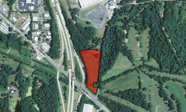
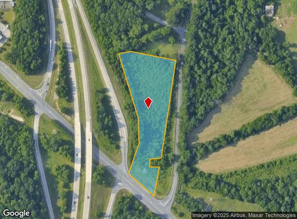
Property Record
Barnes Rd, Winston Salem, NC 27107
NEARBY LISTINGS FOR SALE OR LEASE
Property Detail
Barnes Rd
Winston-Salem, NC
Ptic & South Main St
6832-56-1807
LO:101 BL:2706
Residentialacreage
Forsyth
AE
North Carolina
3710683200J
101
2023
4.31 AC
2025
South Forsyth County
003500
Greensboro/Winston-Salem
DEMOGRAPHICS near Barnes Rd
1 Mile
3 Mile
5 Mile
2024 Total Population
2,574
35,589
96,919
2029 Population
2,729
37,143
101,044
Pop Growth 2024-2029
+ 6.02%
+ 4.37%
+ 4.26%
Average Age
36
38
38
2024 Total Households
930
14,044
38,297
HH Growth 2024-2029
+ 6.02%
+ 4.38%
+ 4.23%
Median Household Inc
$60,091
$54,826
$53,017
Avg Household Size
2.70
2.50
2.40
2024 Avg HH Vehicles
2.00
2.00
2.00
Median Home Value
$179,232
$165,192
$172,251
Median Year Built
2005
1994
1984
Nearby Places
Map Layers
Map Styles
 Street
 Aerial
- Restaurants
- Banks
- Shops
- Fitness
- Groceries
PUBLIC TRANSPORTATION
AIRPORT
Piedmont Triad International
DRIVE
WALK
Distance
Piedmont Triad International
28 min
23.4 mi
SALE & LEASE HISTORY
LISTING DATE
SALE/LEASE

Sep 24, 2016
For Sale
Nearby Properties
Address
Land Use
TOTAL SIZE
Lot Size
Zoning
Address
Land Use
TOTAL SIZE
Lot Size
Zoning
160,152 SF
26 AC
RM12-S,RM1
Address
Land Use
TOTAL SIZE
Lot Size
Zoning
162,844 SF
57.77 AC
IP
Address
Land Use
TOTAL SIZE
Lot Size
Zoning
211,658 SF
27.33 AC
MRB-S
Address
Land Use
TOTAL SIZE
Lot Size
Zoning
79,734 SF
22.54 AC
RM12-S
Address
Land Use
TOTAL SIZE
Lot Size
Zoning
59,612 SF
10.91 AC
MU-S
Address
Land Use
TOTAL SIZE
Lot Size
Zoning
176,680 SF
10.54 AC
MU-S
Address
Land Use
TOTAL SIZE
Lot Size
Zoning
57,837 SF
9.45 AC
RM18-S
Address
Land Use
TOTAL SIZE
Lot Size
Zoning
102,588 SF
13.98 AC
RM18
Address
Land Use
TOTAL SIZE
Lot Size
Zoning
167,500 SF
14.96 AC
GI
Address
Land Use
TOTAL SIZE
Lot Size
Zoning
48,620 SF
15.51 AC
RM12-S
Address
Land Use
TOTAL SIZE
Lot Size
Zoning
992,551 SF
72.46 AC
GI
Address
Land Use
TOTAL SIZE
Lot Size
Zoning
139,248 SF
27.24 AC
MRB-S
Address
Land Use
TOTAL SIZE
Lot Size
Zoning
188,088 SF
26.83 AC
RM18
Address
Land Use
TOTAL SIZE
Lot Size
Zoning
707,739 SF
60.36 AC
GI
Address
Land Use
TOTAL SIZE
Lot Size
Zoning
77,143 SF
12.09 AC
NSB-S
Address
Land Use
TOTAL SIZE
Lot Size
Zoning
469,797 SF
73.87 AC
GI
Address
Land Use
TOTAL SIZE
Lot Size
Zoning
68,010 SF
15.32 AC
IP,RS9
Address
Land Use
TOTAL SIZE
Lot Size
Zoning
96,089 SF
14.91 AC
HB-S
Address
Land Use
TOTAL SIZE
Lot Size
Zoning
115,144 SF
10.31 AC
HB-S
Address
Land Use
TOTAL SIZE
Lot Size
Zoning
87,041 SF
44 AC
RA3
Address
Land Use
TOTAL SIZE
Lot Size
Zoning
77,048 SF
7.76 AC
HC
Address
Land Use
TOTAL SIZE
Lot Size
Zoning
48,831 SF
2.83 AC
GB-S
Address
Land Use
TOTAL SIZE
Lot Size
Zoning
35,395 SF
3.72 AC
MRB-S
Address
Land Use
TOTAL SIZE
Lot Size
Zoning
199,441 SF
7.08 AC
LI
Address
Land Use
TOTAL SIZE
Lot Size
Zoning
45,638 SF
7.30 AC
HB-S
Address
Land Use
TOTAL SIZE
Lot Size
Zoning
32,496 SF
6.74 AC
RM12-S
Address
Land Use
TOTAL SIZE
Lot Size
Zoning
58,597 SF
63.22 AC
GI
Address
Land Use
TOTAL SIZE
Lot Size
Zoning
110,619 SF
4.15 AC
LI
Address
Land Use
TOTAL SIZE
Lot Size
Zoning
10,416 SF
7.25 AC
PDH
Address
Land Use
TOTAL SIZE
Lot Size
Zoning
27,462 SF
10.89 AC
RM18
The World's #1 Commercial Real Estate Marketplace
Connect with us
© 2025 CoStar Group
The information above has been obtained from sources believed reliable. While we do not doubt its accuracy we have not verified it and make no guarantee, warranty or representation about it. It is your responsibility to independently confirm its accuracy and completeness. Any projections, opinions, assumptions, or estimates used are for example only and do not represent the current or future performance of the property. The value of this transaction to you depends on tax and other factors which should be evaluated by your tax, financial, and legal advisors. You and your advisors should conduct a careful, independent investigation of the property to determine to your satisfaction the suitability of the property for your needs.