Property Record
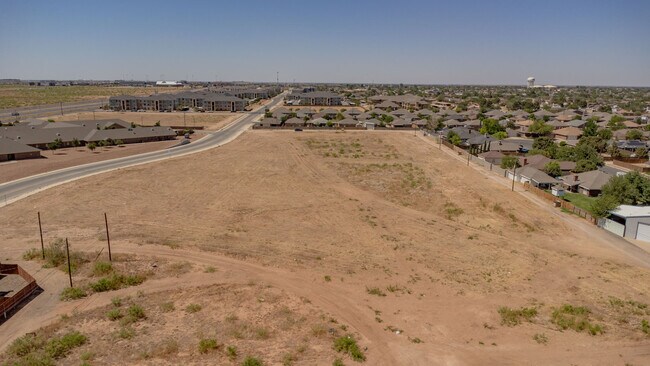
Beal Pkwy, Midland, TX 79703

Property Detail
Beal Pkwy
Midland, TX
ACRES: 4.646 BLK: 022 LOT: 022 LESS 6.969 AC ADDN: WESTERN HILLS SEC 2
R000053-384
MIDLAND
Realpropertynec
Texas
PDSC
22
2025
4.65 AC
2025
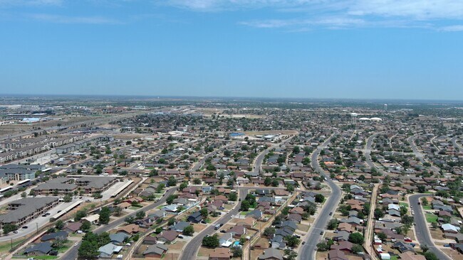
Midland & Odessa
001200
Other Market Areas
NEARBY LISTINGS FOR SALE OR LEASE
DEMOGRAPHICS near Beal Pkwy
1 mile
3 mile
5 mile
2024 Total Population
8,985
47,749
104,056
2029 Population
9,272
48,867
106,728
Pop Growth 2024-2029
+ 3.19%
+ 2.34%
+ 2.57%
Average Age
34
34
35
2024 Total Households
3,133
17,128
38,117
HH Growth 2024-2029
+ 3.64%
+ 2.71%
+ 2.93%
Median Household Inc
$88,806
$79,451
$81,882
Avg Household Size
2.80
2.70
2.60
2024 Avg HH Vehicles
2.00
2.00
2.00
Median Home Value
$218,098
$240,306
$268,093
Median Year Built
1981
1983
1982
Nearby Places
Map Layers
Map Styles
 Street
 Aerial
Transit
 Traffic
 Biking
Places
Listings with unknown addresses are not visible on the map
- Restaurants
- Banks
- Shops
- Fitness
- Groceries
PUBLIC TRANSPORTATION
AIRPORT
Midland International Air And Space Port
Drive
Walk
Distance
Midland International Air And Space Port
12 min
7.0 mi
Freight Ports
Calhoun Port
Drive
Walk
Distance
Calhoun Port
532 min
477.6 mi
SALE & LEASE HISTORY
LISTING DATE
SALE/LEASE

May 05, 2022
For Sale
Jul 27, 2024
For Sale
Nearby Properties
Address
Land Use
TOTAL SIZE
Lot Size
Zoning
Address
Land Use
TOTAL SIZE
Lot Size
Zoning
322,000 SF
24.88 AC
Address
Land Use
TOTAL SIZE
Lot Size
Zoning
25,575 SF
8.90 AC
Address
Land Use
TOTAL SIZE
Lot Size
Zoning
56,157 SF
18.19 AC
PDOC
Address
Land Use
TOTAL SIZE
Lot Size
Zoning
2,339 SF
17.14 AC
Address
Land Use
TOTAL SIZE
Lot Size
Zoning
2,453 SF
13.68 AC
Address
Land Use
TOTAL SIZE
Lot Size
Zoning
1,173 SF
14.05 AC
PDHD
Address
Land Use
TOTAL SIZE
Lot Size
Zoning
24,000 SF
11.87 AC
Address
Land Use
TOTAL SIZE
Lot Size
Zoning
28,750 SF
10.11 AC
Address
Land Use
TOTAL SIZE
Lot Size
Zoning
Address
Land Use
TOTAL SIZE
Lot Size
Zoning
15,000 SF
39.46 AC
PDHD
Address
Land Use
TOTAL SIZE
Lot Size
Zoning
44,784 SF
11.97 AC
MF1
Address
Land Use
TOTAL SIZE
Lot Size
Zoning
6,864 SF
10.35 AC
Address
Land Use
TOTAL SIZE
Lot Size
Zoning
209,680 SF
6.16 AC
Address
Land Use
TOTAL SIZE
Lot Size
Zoning
1,678 SF
9.11 AC
MF1
Address
Land Use
TOTAL SIZE
Lot Size
Zoning
5,600 SF
10.18 AC
PDMX
Address
Land Use
TOTAL SIZE
Lot Size
Zoning
1,618 SF
4.18 AC
Address
Land Use
TOTAL SIZE
Lot Size
Zoning
1,868 SF
8.47 AC
MF1
Address
Land Use
TOTAL SIZE
Lot Size
Zoning
111,354 SF
8.34 AC
Address
Land Use
TOTAL SIZE
Lot Size
Zoning
137,457 SF
8.73 AC
MF1
Address
Land Use
TOTAL SIZE
Lot Size
Zoning
442 SF
2.99 AC
Address
Land Use
TOTAL SIZE
Lot Size
Zoning
1,956 SF
7.58 AC
MF1
Address
Land Use
TOTAL SIZE
Lot Size
Zoning
12,420 SF
40.94 AC
Address
Land Use
TOTAL SIZE
Lot Size
Zoning
55,790 SF
2.54 AC
PDSC
Address
Land Use
TOTAL SIZE
Lot Size
Zoning
11,716 SF
1.49 AC
Address
Land Use
TOTAL SIZE
Lot Size
Zoning
21,373 SF
2.82 AC
PDSC
Address
Land Use
TOTAL SIZE
Lot Size
Zoning
37,500 SF
3.93 AC
Address
Land Use
TOTAL SIZE
Lot Size
Zoning
3,399 SF
648 AC
Address
Land Use
TOTAL SIZE
Lot Size
Zoning
105,182 SF
5.29 AC
MF1
Address
Land Use
TOTAL SIZE
Lot Size
Zoning
20,440 SF
3.01 AC
PDSC
Address
Land Use
TOTAL SIZE
Lot Size
Zoning
103,600 SF
2.94 AC
The World's #1 Commercial Real Estate Marketplace
Connect with us
© 2026 CoStar Group
The information above has been obtained from sources believed reliable. While we do not doubt its accuracy we have not verified it and make no guarantee, warranty or representation about it. It is your responsibility to independently confirm its accuracy and completeness. Any projections, opinions, assumptions, or estimates used are for example only and do not represent the current or future performance of the property. The value of this transaction to you depends on tax and other factors which should be evaluated by your tax, financial, and legal advisors. You and your advisors should conduct a careful, independent investigation of the property to determine to your satisfaction the suitability of the property for your needs.