Property Record
Bearpond Rd, Henderson, NC 27537

This Property Is For Sale
NEARBY LISTINGS FOR SALE OR LEASE
Property Detail
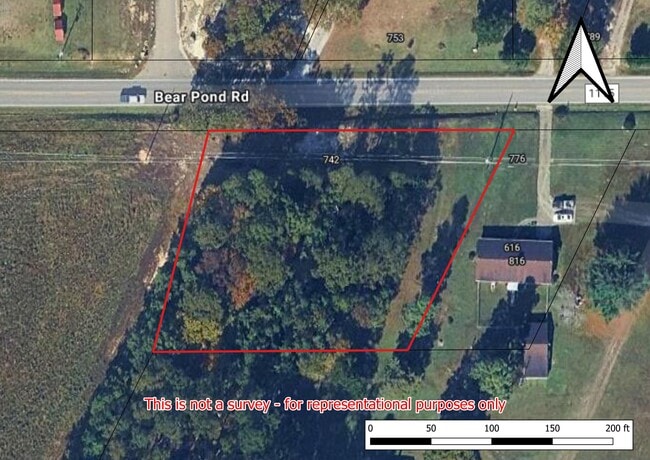
Bearpond Rd
0453-05004
BEARPOND RD 1.000
Residentialacreage
Vance
X
North Carolina
3720196000J
0.95 AC
2025
North Carolina Northeast Area
2025
Other Market Areas
960600
Henderson, NC
DEMOGRAPHICS near Bearpond Rd
1 Mile
3 Mile
5 Mile
2024 Total Population
624
8,485
27,123
2029 Population
626
8,562
27,300
Pop Growth 2024-2029
+ 0.32%
+ 0.91%
+ 0.65%
Average Age
41
39
40
2024 Total Households
242
3,232
10,799
HH Growth 2024-2029
0.00%
+ 0.90%
+ 0.64%
Median Household Inc
$69,374
$49,540
$44,781
Avg Household Size
2.50
2.60
2.40
2024 Avg HH Vehicles
2.00
2.00
2.00
Median Home Value
$155,833
$116,998
$140,503
Median Year Built
1988
1981
1975
Nearby Places
Map Layers
Map Styles
 Street
 Aerial
- Restaurants
- Banks
- Shops
- Fitness
- Groceries
PUBLIC TRANSPORTATION
AIRPORT
Raleigh-Durham International
DRIVE
WALK
Distance
Raleigh-Durham International
62 min
43.8 mi
Nearby Properties
Address
Land Use
TOTAL SIZE
Lot Size
Zoning
Address
Land Use
TOTAL SIZE
Lot Size
Zoning
149,688 SF
131.64 AC
HI2
Address
Land Use
TOTAL SIZE
Lot Size
Zoning
603,204 SF
45.50 AC
HI2
Address
Land Use
TOTAL SIZE
Lot Size
Zoning
51,768 SF
40.75 AC
HR8M
Address
Land Use
TOTAL SIZE
Lot Size
Zoning
167,900 SF
70.82 AC
HR15
Address
Land Use
TOTAL SIZE
Lot Size
Zoning
230,400 SF
69.68 AC
HI2
Address
Land Use
TOTAL SIZE
Lot Size
Zoning
22,572 SF
88.80 AC
HR15M
Address
Land Use
TOTAL SIZE
Lot Size
Zoning
214,900 SF
25.24 AC
HI2
Address
Land Use
TOTAL SIZE
Lot Size
Zoning
24,888 SF
33.39 AC
HR20
Address
Land Use
TOTAL SIZE
Lot Size
Zoning
158,500 SF
18.56 AC
LI
Address
Land Use
TOTAL SIZE
Lot Size
Zoning
257,656 SF
31.28 AC
HI2
Address
Land Use
TOTAL SIZE
Lot Size
Zoning
109,130 SF
26.76 AC
Address
Land Use
TOTAL SIZE
Lot Size
Zoning
62,129 SF
26.02 AC
OI
Address
Land Use
TOTAL SIZE
Lot Size
Zoning
12,000 SF
1.50 AC
HI2
Address
Land Use
TOTAL SIZE
Lot Size
Zoning
55,900 SF
16.19 AC
Address
Land Use
TOTAL SIZE
Lot Size
Zoning
65,156 SF
46.85 AC
HI2
Address
Land Use
TOTAL SIZE
Lot Size
Zoning
35,775 SF
11.97 AC
HB4
Address
Land Use
TOTAL SIZE
Lot Size
Zoning
96,000 SF
14.98 AC
HI2
Address
Land Use
TOTAL SIZE
Lot Size
Zoning
117,068 SF
31.86 AC
HI2
Address
Land Use
TOTAL SIZE
Lot Size
Zoning
59,920 SF
15 AC
LI
Address
Land Use
TOTAL SIZE
Lot Size
Zoning
22,443 SF
6.22 AC
HI2
Address
Land Use
TOTAL SIZE
Lot Size
Zoning
132,750 SF
25.47 AC
GC1
Address
Land Use
TOTAL SIZE
Lot Size
Zoning
17,220 SF
40.78 AC
HI2
Address
Land Use
TOTAL SIZE
Lot Size
Zoning
72,370 SF
14.61 AC
HI2
Address
Land Use
TOTAL SIZE
Lot Size
Zoning
45,653 SF
6.15 AC
HR8M
Address
Land Use
TOTAL SIZE
Lot Size
Zoning
57,290 SF
24.65 AC
HI2
Address
Land Use
TOTAL SIZE
Lot Size
Zoning
15,652 SF
20.67 AC
HI2
Address
Land Use
TOTAL SIZE
Lot Size
Zoning
134,400 SF
14.03 AC
HI2
Address
Land Use
TOTAL SIZE
Lot Size
Zoning
10,724 SF
8.10 AC
HI2
Address
Land Use
TOTAL SIZE
Lot Size
Zoning
7,024 SF
10.59 AC
HR6
Address
Land Use
TOTAL SIZE
Lot Size
Zoning
18,120 SF
2.05 AC
HC
The World's #1 Commercial Real Estate Marketplace
Connect with us
© 2025 CoStar Group
The information above has been obtained from sources believed reliable. While we do not doubt its accuracy we have not verified it and make no guarantee, warranty or representation about it. It is your responsibility to independently confirm its accuracy and completeness. Any projections, opinions, assumptions, or estimates used are for example only and do not represent the current or future performance of the property. The value of this transaction to you depends on tax and other factors which should be evaluated by your tax, financial, and legal advisors. You and your advisors should conduct a careful, independent investigation of the property to determine to your satisfaction the suitability of the property for your needs.