Property Record
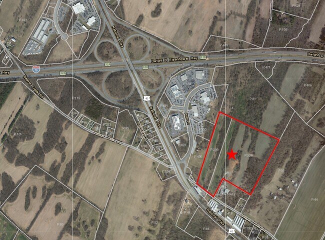
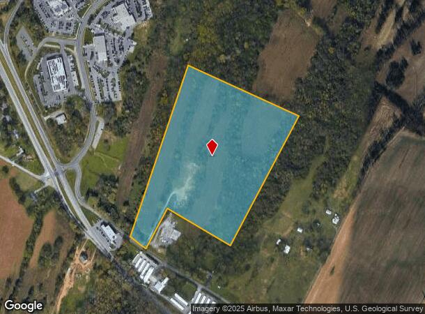
Beaver Creek Rd, Hagerstown, MD 21740
NEARBY LISTINGS FOR SALE OR LEASE
Property Detail
Beaver Creek Rd
16-011886
Beaver Creek
Agriculturalland
28.54 ACRES N/S BEAVER CREEK ROAD
A
Washington
24043C0306D
Maryland
2024
28.54 AC
2025
Washington County
000900
Washington, DC
4,379 SF
Hagerstown-Martinsburg, MD-WV
DEMOGRAPHICS near Beaver Creek Rd
1 mile
3 mile
5 mile
2024 Total Population
784
17,774
70,151
2029 Population
790
18,055
71,219
Pop Growth 2024-2029
+ 0.77%
+ 1.58%
+ 1.52%
Average Age
45
42
40
2024 Total Households
323
7,220
28,148
HH Growth 2024-2029
+ 0.62%
+ 1.58%
+ 1.54%
Median Household Inc
$109,868
$73,853
$54,888
Avg Household Size
2.40
2.40
2.40
2024 Avg HH Vehicles
2.00
2.00
2.00
Median Home Value
$314,151
$262,596
$218,166
Median Year Built
1989
1986
1970
Nearby Places
Map Layers
Map Styles
 Street
 Aerial
Transit
 Traffic
 Biking
Places
Listings with unknown addresses are not visible on the map
- Restaurants
- Banks
- Shops
- Fitness
- Groceries
PUBLIC TRANSPORTATION
AIRPORT
Hagerstown Regional/Richard A Henson Field
Drive
Walk
Distance
Hagerstown Regional/Richard A Henson Field
17 min
9.2 mi
Freight Ports
Port of Baltimore
Drive
Walk
Distance
Port of Baltimore
85 min
71.4 mi
SALE & LEASE HISTORY
LISTING DATE
SALE/LEASE

Feb 12, 2021
For Sale
Nearby Properties
Address
Land Use
TOTAL SIZE
Lot Size
Zoning
Address
Land Use
TOTAL SIZE
Lot Size
Zoning
502,262 SF
36.64 AC
ORI
Address
Land Use
TOTAL SIZE
Lot Size
Zoning
1,236,085 SF
134.31 AC
IMU
Address
Land Use
TOTAL SIZE
Lot Size
Zoning
77,027 SF
310.67 AC
ERT
Address
Land Use
TOTAL SIZE
Lot Size
Zoning
200,815 SF
9.14 AC
ORI
Address
Land Use
TOTAL SIZE
Lot Size
Zoning
76.18 AC
U
Address
Land Use
TOTAL SIZE
Lot Size
Zoning
290,600 SF
51.35 AC
IMU
Address
Land Use
TOTAL SIZE
Lot Size
Zoning
7,427 SF
79.25 AC
RS
Address
Land Use
TOTAL SIZE
Lot Size
Zoning
67,434 SF
4.30 AC
RS
Address
Land Use
TOTAL SIZE
Lot Size
Zoning
80,816 SF
19.68 AC
ORI
Address
Land Use
TOTAL SIZE
Lot Size
Zoning
29,405 SF
29.47 AC
RH
Address
Land Use
TOTAL SIZE
Lot Size
Zoning
4,180 SF
244.75 AC
RT
Address
Land Use
TOTAL SIZE
Lot Size
Zoning
9.86 AC
CR
Address
Land Use
TOTAL SIZE
Lot Size
Zoning
8.01 AC
RS-PU
Address
Land Use
TOTAL SIZE
Lot Size
Zoning
45,305 SF
5.17 AC
RS-PU
Address
Land Use
TOTAL SIZE
Lot Size
Zoning
10,659 SF
142.91 AC
IR
Address
Land Use
TOTAL SIZE
Lot Size
Zoning
18,228 SF
7.75 AC
RS-PU
Address
Land Use
TOTAL SIZE
Lot Size
Zoning
30,660 SF
7.53 AC
RSPUD
Address
Land Use
TOTAL SIZE
Lot Size
Zoning
58,280 SF
20.16 AC
RS
Address
Land Use
TOTAL SIZE
Lot Size
Zoning
18,300 SF
8.76 AC
RS-PU
Address
Land Use
TOTAL SIZE
Lot Size
Zoning
107,520 SF
6.88 AC
RH
Address
Land Use
TOTAL SIZE
Lot Size
Zoning
9.69 AC
RS-PU
Address
Land Use
TOTAL SIZE
Lot Size
Zoning
28,395 SF
6.20 AC
RH
Address
Land Use
TOTAL SIZE
Lot Size
Zoning
25,946 SF
6.03 AC
POM
Address
Land Use
TOTAL SIZE
Lot Size
Zoning
106,460 SF
11.63 AC
IR
Address
Land Use
TOTAL SIZE
Lot Size
Zoning
55,897 SF
4.30 AC
CG
Address
Land Use
TOTAL SIZE
Lot Size
Zoning
8,925 SF
10.30 AC
HI
Address
Land Use
TOTAL SIZE
Lot Size
Zoning
28,842 SF
6.05 AC
RH
Address
Land Use
TOTAL SIZE
Lot Size
Zoning
16,530 SF
18.89 AC
ORI
Address
Land Use
TOTAL SIZE
Lot Size
Zoning
45,000 SF
3.70 AC
BG
Address
Land Use
TOTAL SIZE
Lot Size
Zoning
5,000 SF
3.95 AC
CG
The World's #1 Commercial Real Estate Marketplace
Connect with us
© 2026 CoStar Group
The information above has been obtained from sources believed reliable. While we do not doubt its accuracy we have not verified it and make no guarantee, warranty or representation about it. It is your responsibility to independently confirm its accuracy and completeness. Any projections, opinions, assumptions, or estimates used are for example only and do not represent the current or future performance of the property. The value of this transaction to you depends on tax and other factors which should be evaluated by your tax, financial, and legal advisors. You and your advisors should conduct a careful, independent investigation of the property to determine to your satisfaction the suitability of the property for your needs.