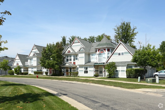
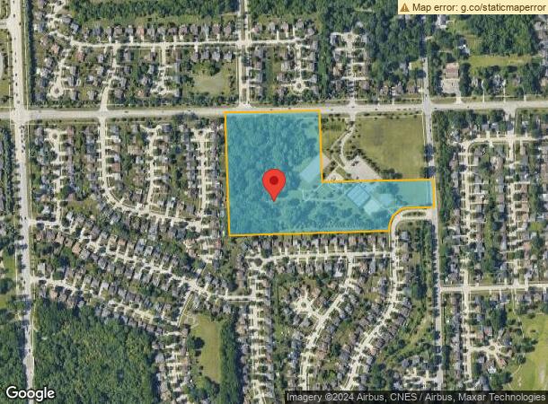
Property Record
Beck Rd S, Canton, MI 48188

Property Detail
Beck Rd S
71-130-99-0003-701
33K THAT PART OF THE NW 1/4 OF SEC 33, T.2S., R.8E., DESC AS BEG AT THE W 1/4 COR SEC 33, TH N 00DEG 00MIN 06 DEG W, 659.54
Commercialnec
WAYNE
R-6
Michigan
B and X Area of moderate flood hazard, usually the area between the limits of the 100-year and 500-year floods.
0003
2025
19.49 AC
2025
Canton
564800
Detroit
206,896 SF
Detroit-Warren-Dearborn, MI
NEARBY LISTINGS FOR SALE OR LEASE
-
-
View all Canton listings for sale on LoopNet.com
DEMOGRAPHICS near Beck Rd S
1 mile
3 mile
5 mile
2025 Total Population
5,513
45,017
135,963
2030 Population
5,533
44,652
134,385
Pop Growth 2025-2030
+ 0.36%
(0.81%)
(1.16%)
Average Age
44
40
40
2025 Total Households
2,416
16,334
52,207
HH Growth 2025-2030
+ 0.46%
(0.79%)
(1.15%)
Median Household Inc
$100,165
$116,084
$96,598
Avg Household Size
2.20
2.70
2.50
2025 Avg HH Vehicles
2.00
2.00
2.00
Median Home Value
$333,403
$362,173
$308,950
Median Year Built
2000
1998
1987
Nearby Places
Map Layers
Map Styles
 Street
 Aerial
Layers
 Traffic
 Biking
Places
Listings with unknown addresses are not visible on the map
- Restaurants
- Banks
- Shops
- Fitness
- Groceries
PUBLIC TRANSPORTATION
AIRPORT
Detroit Metro Wayne County
Drive
Walk
Distance
Detroit Metro Wayne County
19 min
13.8 mi
Windsor International
Drive
Walk
Distance
Windsor International
62 min
41.0 mi
Freight Ports
Port of Toledo
Drive
Walk
Distance
Port of Toledo
69 min
55.4 mi
Nearby Properties
Address
Land Use
TOTAL SIZE
Lot Size
Zoning
Address
Land Use
TOTAL SIZE
Lot Size
Zoning
347,606 SF
71.56 AC
M2 GEN
Address
Land Use
TOTAL SIZE
Lot Size
Zoning
17.50 AC
R-2
Address
Land Use
TOTAL SIZE
Lot Size
Zoning
39.50 AC
MR
Address
Land Use
TOTAL SIZE
Lot Size
Zoning
387,834 SF
71.56 AC
M2 GEN
Address
Land Use
TOTAL SIZE
Lot Size
Zoning
176,796 SF
17.08 AC
C-2
Address
Land Use
TOTAL SIZE
Lot Size
Zoning
167,491 SF
18.59 AC
Address
Land Use
TOTAL SIZE
Lot Size
Zoning
1,182 SF
25.21 AC
G-1
Address
Land Use
TOTAL SIZE
Lot Size
Zoning
311,556 SF
23.17 AC
C-3
Address
Land Use
TOTAL SIZE
Lot Size
Zoning
182,952 SF
82.77 AC
Address
Land Use
TOTAL SIZE
Lot Size
Zoning
524,171 SF
42.18 AC
M2 GEN
Address
Land Use
TOTAL SIZE
Lot Size
Zoning
685,104 SF
44.25 AC
M1 LIG
Address
Land Use
TOTAL SIZE
Lot Size
Zoning
24.63 AC
MR
Address
Land Use
TOTAL SIZE
Lot Size
Zoning
136,775 SF
15.54 AC
C-3
Address
Land Use
TOTAL SIZE
Lot Size
Zoning
20.91 AC
Address
Land Use
TOTAL SIZE
Lot Size
Zoning
450,840 SF
32.59 AC
Address
Land Use
TOTAL SIZE
Lot Size
Zoning
169,489 SF
14.51 AC
R-6
Address
Land Use
TOTAL SIZE
Lot Size
Zoning
190,344 SF
18.24 AC
R-6
Address
Land Use
TOTAL SIZE
Lot Size
Zoning
443,082 SF
30.01 AC
LI-2
Address
Land Use
TOTAL SIZE
Lot Size
Zoning
Address
Land Use
TOTAL SIZE
Lot Size
Zoning
169,968 SF
12.46 AC
MR
Address
Land Use
TOTAL SIZE
Lot Size
Zoning
630,828 SF
62.51 AC
R1B
Address
Land Use
TOTAL SIZE
Lot Size
Zoning
186,967 SF
9.75 AC
Address
Land Use
TOTAL SIZE
Lot Size
Zoning
11.40 AC
MR
Address
Land Use
TOTAL SIZE
Lot Size
Zoning
147,968 SF
16.68 AC
Address
Land Use
TOTAL SIZE
Lot Size
Zoning
66,670 SF
11.20 AC
C-3
Address
Land Use
TOTAL SIZE
Lot Size
Zoning
78,205 SF
14.66 AC
RR
Address
Land Use
TOTAL SIZE
Lot Size
Zoning
100,098 SF
10.52 AC
C-2
Address
Land Use
TOTAL SIZE
Lot Size
Zoning
73,056 SF
7.44 AC
C-3
Address
Land Use
TOTAL SIZE
Lot Size
Zoning
187,281 SF
26.35 AC
C-2
The World's #1 Commercial Real Estate Marketplace
Connect with us
© 2026 CoStar Group
The information above has been obtained from sources believed reliable. While we do not doubt its accuracy we have not verified it and make no guarantee, warranty or representation about it. It is your responsibility to independently confirm its accuracy and completeness. Any projections, opinions, assumptions, or estimates used are for example only and do not represent the current or future performance of the property. The value of this transaction to you depends on tax and other factors which should be evaluated by your tax, financial, and legal advisors. You and your advisors should conduct a careful, independent investigation of the property to determine to your satisfaction the suitability of the property for your needs.