Property Record
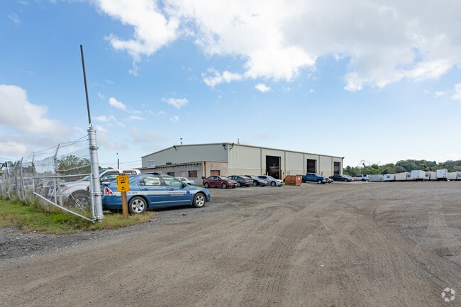
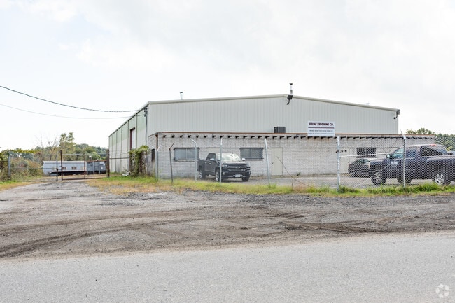
Beech Rd, Dundalk, MD 21222

Property Detail
Beech Rd
15-1501740882
LT SS OF FISCHER RD
Autorepair
BALTIMORE
MLIM
Maryland
AE The base floodplain where base flood elevations are provided. AE Zones are now used on new format FIRMs instead of A1-A30 Zones.
9.20 AC
2024
Baltimore County East
2025
Baltimore
452400
Baltimore-Columbia-Towson, MD
2,400 SF
NEARBY LISTINGS FOR SALE OR LEASE
DEMOGRAPHICS near Beech Rd
1 mile
3 mile
5 mile
2025 Total Population
3,341
73,780
167,894
2030 Population
3,342
73,994
168,272
Pop Growth 2025-2030
+ 0.03%
+ 0.29%
+ 0.23%
Average Age
40
40
40
2025 Total Households
1,178
28,359
63,972
HH Growth 2025-2030
(0.08%)
+ 0.31%
+ 0.26%
Median Household Inc
$71,435
$67,547
$66,838
Avg Household Size
2.70
2.50
2.60
2025 Avg HH Vehicles
2.00
2.00
2.00
Median Home Value
$270,810
$242,490
$250,321
Median Year Built
1958
1957
1957
Nearby Places
Map Layers
Map Styles
 Street
 Aerial
Transit
 Traffic
 Biking
Places
Listings with unknown addresses are not visible on the map
- Restaurants
- Banks
- Shops
- Fitness
- Groceries
PUBLIC TRANSPORTATION
AIRPORT
Baltimore/Washington International Thurgood Marshall
Drive
Walk
Distance
Baltimore/Washington International Thurgood Marshall
34 min
21.1 mi
Freight Ports
Port of Baltimore
Drive
Walk
Distance
Port of Baltimore
22 min
10.8 mi
SALE & LEASE HISTORY
LISTING DATE
SALE/LEASE

Oct 01, 2021
For Lease
Nov 19, 2020
For Lease
Nearby Properties
Address
Land Use
TOTAL SIZE
Lot Size
Zoning
Address
Land Use
TOTAL SIZE
Lot Size
Zoning
449,920 SF
26.42 AC
Address
Land Use
TOTAL SIZE
Lot Size
Zoning
33.65 AC
DR16
Address
Land Use
TOTAL SIZE
Lot Size
Zoning
135,548 SF
13 AC
DR5.5
Address
Land Use
TOTAL SIZE
Lot Size
Zoning
213,997 SF
45.22 AC
DR
Address
Land Use
TOTAL SIZE
Lot Size
Zoning
13.72 AC
DR16
Address
Land Use
TOTAL SIZE
Lot Size
Zoning
197,823 SF
34.32 AC
DR5.5
Address
Land Use
TOTAL SIZE
Lot Size
Zoning
23.40 AC
DR16
Address
Land Use
TOTAL SIZE
Lot Size
Zoning
3,099 SF
16.10 AC
BM
Address
Land Use
TOTAL SIZE
Lot Size
Zoning
189,347 SF
28.24 AC
DR10
Address
Land Use
TOTAL SIZE
Lot Size
Zoning
28,963 SF
60.65 AC
BM-CT
Address
Land Use
TOTAL SIZE
Lot Size
Zoning
19 AC
DR16
Address
Land Use
TOTAL SIZE
Lot Size
Zoning
24.95 AC
DR16
Address
Land Use
TOTAL SIZE
Lot Size
Zoning
126,096 SF
14.68 AC
DR105
Address
Land Use
TOTAL SIZE
Lot Size
Zoning
10.27 AC
DR16
Address
Land Use
TOTAL SIZE
Lot Size
Zoning
10.48 AC
DR16
Address
Land Use
TOTAL SIZE
Lot Size
Zoning
463,050 SF
24.27 AC
ML
Address
Land Use
TOTAL SIZE
Lot Size
Zoning
237,925 SF
28.28 AC
Address
Land Use
TOTAL SIZE
Lot Size
Zoning
12.25 AC
DR16
Address
Land Use
TOTAL SIZE
Lot Size
Zoning
119,700 SF
6.97 AC
Address
Land Use
TOTAL SIZE
Lot Size
Zoning
14.14 AC
DR16
Address
Land Use
TOTAL SIZE
Lot Size
Zoning
104,238 SF
13.26 AC
BM
Address
Land Use
TOTAL SIZE
Lot Size
Zoning
108,560 SF
7.64 AC
Address
Land Use
TOTAL SIZE
Lot Size
Zoning
171,986 SF
9.23 AC
BL
Address
Land Use
TOTAL SIZE
Lot Size
Zoning
14.13 AC
DR16
Address
Land Use
TOTAL SIZE
Lot Size
Zoning
390.80 AC
MLIM
Address
Land Use
TOTAL SIZE
Lot Size
Zoning
16.15 AC
DR16
Address
Land Use
TOTAL SIZE
Lot Size
Zoning
288,938 SF
15.27 AC
MH-IM
Address
Land Use
TOTAL SIZE
Lot Size
Zoning
114,682 SF
9.91 AC
BM
Address
Land Use
TOTAL SIZE
Lot Size
Zoning
347,373 SF
32.06 AC
Address
Land Use
TOTAL SIZE
Lot Size
Zoning
72,118 SF
10.10 AC
DR5.5
The World's #1 Commercial Real Estate Marketplace
Connect with us
© 2026 CoStar Group
The information above has been obtained from sources believed reliable. While we do not doubt its accuracy we have not verified it and make no guarantee, warranty or representation about it. It is your responsibility to independently confirm its accuracy and completeness. Any projections, opinions, assumptions, or estimates used are for example only and do not represent the current or future performance of the property. The value of this transaction to you depends on tax and other factors which should be evaluated by your tax, financial, and legal advisors. You and your advisors should conduct a careful, independent investigation of the property to determine to your satisfaction the suitability of the property for your needs.