Property Record
Beech St, Ceredo, WV 25507

Save to a Folder
{{folder.Name}}
{{folder.ListingIds.length}} Properties
{{folder.ListingIds.length}} Property
Create a New Folder
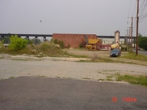
Property Detail
Beech St
Huntington-Ashland, WV-KY-OH
15.926 AC
03-2-00030000
WAYNE
Manufacturinglight
West Virginia
AE The base floodplain where base flood elevations are provided. AE Zones are now used on new format FIRMs instead of A1-A30 Zones.
15.93 AC
2025
Wayne County
2025
Huntington/Ashland
020400
NEARBY LISTINGS FOR SALE OR LEASE
DEMOGRAPHICS near Beech St
1 mile
3 mile
5 mile
2025 Total Population
4,392
14,494
36,619
2030 Population
4,217
14,074
35,681
Pop Growth 2025-2030
(3.98%)
(2.90%)
(2.56%)
Average Age
42
43
42
2025 Total Households
1,922
6,043
15,323
HH Growth 2025-2030
(3.90%)
(2.91%)
(2.54%)
Median Household Inc
$55,258
$58,311
$58,067
Avg Household Size
2.20
2.30
2.30
2025 Avg HH Vehicles
2.00
2.00
2.00
Median Home Value
$147,816
$152,281
$149,027
Median Year Built
1962
1970
1968
Nearby Places
Map Layers
Map Styles
 Street
 Aerial
Layers
 Traffic
 Biking
Places
Listings with unknown addresses are not visible on the map
- Restaurants
- Banks
- Shops
- Fitness
- Groceries
PUBLIC TRANSPORTATION
COMMUTER RAIL
Huntington Amtrak Station (Cardinal - Amtrak)
Drive
Walk
Distance
Huntington Amtrak Station (Cardinal - Amtrak)
16 min
7.3 mi
Ashland Amtrak Station (Cardinal - Amtrak)
Drive
Walk
Distance
Ashland Amtrak Station (Cardinal - Amtrak)
15 min
8.8 mi
AIRPORT
Tri-State/Milton J Ferguson Field
Drive
Walk
Distance
Tri-State/Milton J Ferguson Field
12 min
5.9 mi
Freight Ports
Port of Toledo
Drive
Walk
Distance
Port of Toledo
348 min
266.2 mi
Nearby Properties
Address
Land Use
TOTAL SIZE
Lot Size
Zoning
Address
Land Use
TOTAL SIZE
Lot Size
Zoning
0.69 AC
Z02
Address
Land Use
TOTAL SIZE
Lot Size
Zoning
492.60 AC
Address
Land Use
TOTAL SIZE
Lot Size
Zoning
Address
Land Use
TOTAL SIZE
Lot Size
Zoning
Address
Land Use
TOTAL SIZE
Lot Size
Zoning
123,920 SF
6.81 AC
Address
Land Use
TOTAL SIZE
Lot Size
Zoning
2.83 AC
Address
Land Use
TOTAL SIZE
Lot Size
Zoning
348,219 SF
12 AC
Address
Land Use
TOTAL SIZE
Lot Size
Zoning
0.10 AC
OTHER
Address
Land Use
TOTAL SIZE
Lot Size
Zoning
0.74 AC
Address
Land Use
TOTAL SIZE
Lot Size
Zoning
Address
Land Use
TOTAL SIZE
Lot Size
Zoning
126,716 SF
10.60 AC
Address
Land Use
TOTAL SIZE
Lot Size
Zoning
Address
Land Use
TOTAL SIZE
Lot Size
Zoning
33.45 AC
COMMERCIAL
Address
Land Use
TOTAL SIZE
Lot Size
Zoning
132,113 SF
4.38 AC
Address
Land Use
TOTAL SIZE
Lot Size
Zoning
27,084 SF
3.73 AC
Address
Land Use
TOTAL SIZE
Lot Size
Zoning
68,160 SF
0.87 AC
Z01
Address
Land Use
TOTAL SIZE
Lot Size
Zoning
3.85 AC
OTHER
Address
Land Use
TOTAL SIZE
Lot Size
Zoning
Address
Land Use
TOTAL SIZE
Lot Size
Zoning
Address
Land Use
TOTAL SIZE
Lot Size
Zoning
Address
Land Use
TOTAL SIZE
Lot Size
Zoning
Address
Land Use
TOTAL SIZE
Lot Size
Zoning
32,400 SF
3 AC
Address
Land Use
TOTAL SIZE
Lot Size
Zoning
3.94 AC
COMMERCIAL
Address
Land Use
TOTAL SIZE
Lot Size
Zoning
0.87 AC
RESIDENTIA
Address
Land Use
TOTAL SIZE
Lot Size
Zoning
75,900 SF
6.04 AC
Address
Land Use
TOTAL SIZE
Lot Size
Zoning
0.27 AC
Z02
Address
Land Use
TOTAL SIZE
Lot Size
Zoning
19.68 AC
Address
Land Use
TOTAL SIZE
Lot Size
Zoning
2.78 AC
Z01
Address
Land Use
TOTAL SIZE
Lot Size
Zoning
60,000 SF
5 AC
Address
Land Use
TOTAL SIZE
Lot Size
Zoning
12.15 AC
The World's #1 Commercial Real Estate Marketplace
Connect with us
© 2026 CoStar Group
The information above has been obtained from sources believed reliable. While we do not doubt its accuracy we have not verified it and make no guarantee, warranty or representation about it. It is your responsibility to independently confirm its accuracy and completeness. Any projections, opinions, assumptions, or estimates used are for example only and do not represent the current or future performance of the property. The value of this transaction to you depends on tax and other factors which should be evaluated by your tax, financial, and legal advisors. You and your advisors should conduct a careful, independent investigation of the property to determine to your satisfaction the suitability of the property for your needs.